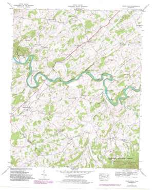
Cedar Creek Topo Map Tennessee
To zoom in, hover over the map of Cedar Creek
USGS Topo Quad 36082a8 - 1:24,000 scale
| Topo Map Name: | Cedar Creek |
| USGS Topo Quad ID: | 36082a8 |
| Print Size: | ca. 21 1/4" wide x 27" high |
| Southeast Coordinates: | 36° N latitude / 82.875° W longitude |
| Map Center Coordinates: | 36.0625° N latitude / 82.9375° W longitude |
| U.S. State: | TN |
| Filename: | o36082a8.jpg |
| Download Map JPG Image: | Cedar Creek topo map 1:24,000 scale |
| Map Type: | Topographic |
| Topo Series: | 7.5´ |
| Map Scale: | 1:24,000 |
| Source of Map Images: | United States Geological Survey (USGS) |
| Alternate Map Versions: |
Cedar Creek TN 1935 Download PDF Buy paper map Cedar Creek TN 1939 Download PDF Buy paper map Cedar Creek TN 1939 Download PDF Buy paper map Cedar Creek TN 1939, updated 1954 Download PDF Buy paper map Cedar Creek TN 1939, updated 1981 Download PDF Buy paper map Cedar Creek TN 1966, updated 1984 Download PDF Buy paper map Cedar Creek TN 2003, updated 2004 Download PDF Buy paper map Cedar Creek TN 2011 Download PDF Buy paper map Cedar Creek TN 2013 Download PDF Buy paper map Cedar Creek TN 2016 Download PDF Buy paper map |
| FStopo: | US Forest Service topo Cedar Creek is available: Download FStopo PDF Download FStopo TIF |
1:24,000 Topo Quads surrounding Cedar Creek
> Back to 36082a1 at 1:100,000 scale
> Back to 36082a1 at 1:250,000 scale
> Back to U.S. Topo Maps home
Cedar Creek topo map: Gazetteer
Cedar Creek: Bars
Cove Creek Shoals elevation 356m 1167′Dikes Shoals elevation 353m 1158′
Hendersons Shoals elevation 343m 1125′
Cedar Creek: Bends
Cochran Bend elevation 369m 1210′Linebaugh Bend elevation 374m 1227′
Cedar Creek: Bridges
Allen Bridge elevation 353m 1158′Easterly Bridge elevation 336m 1102′
Love Bridge elevation 344m 1128′
Cedar Creek: Crossings
Walker Ford elevation 359m 1177′Cedar Creek: Islands
Evans Island elevation 343m 1125′Grays Island elevation 356m 1167′
Johnson Island elevation 353m 1158′
Jones Island elevation 350m 1148′
Russell Island elevation 351m 1151′
Susong Island elevation 357m 1171′
Cedar Creek: Lakes
Birdwell Pond elevation 399m 1309′Hogan Pond elevation 395m 1295′
Cedar Creek: Populated Places
Allenbridge (historical) elevation 362m 1187′Bright Hope elevation 376m 1233′
Caney Branch elevation 377m 1236′
Cedar Creek elevation 413m 1354′
DeBusk elevation 436m 1430′
Little Chucky (historical) elevation 408m 1338′
Oak Hill elevation 443m 1453′
Russell Crossroad elevation 391m 1282′
Saint James elevation 426m 1397′
Sirenburg (historical) elevation 447m 1466′
Timber Ridge elevation 390m 1279′
Walter Crossroad elevation 414m 1358′
Cedar Creek: Springs
Luttrell Spring elevation 365m 1197′Cedar Creek: Streams
Bales Creek elevation 339m 1112′Buffalo Creek elevation 385m 1263′
Caney Branch elevation 345m 1131′
Cedar Creek elevation 371m 1217′
Cove Creek elevation 356m 1167′
Dodd Branch elevation 386m 1266′
Dry Branch elevation 383m 1256′
Dry Branch elevation 339m 1112′
Furness Branch elevation 339m 1112′
Gregg Creek elevation 353m 1158′
Harris Branch elevation 337m 1105′
Little Meadow Creek elevation 375m 1230′
Meadow Creek elevation 353m 1158′
Pigeon Branch elevation 409m 1341′
Pigeon Creek elevation 347m 1138′
Privet Branch elevation 350m 1148′
Cedar Creek: Valleys
Evans Valley elevation 349m 1145′Franklin Hollow elevation 403m 1322′
Seven Springs Valley elevation 368m 1207′
Cedar Creek digital topo map on disk
Buy this Cedar Creek topo map showing relief, roads, GPS coordinates and other geographical features, as a high-resolution digital map file on DVD:
Western Virginia & Southern West Virginia
Buy digital topo maps: Western Virginia & Southern West Virginia


