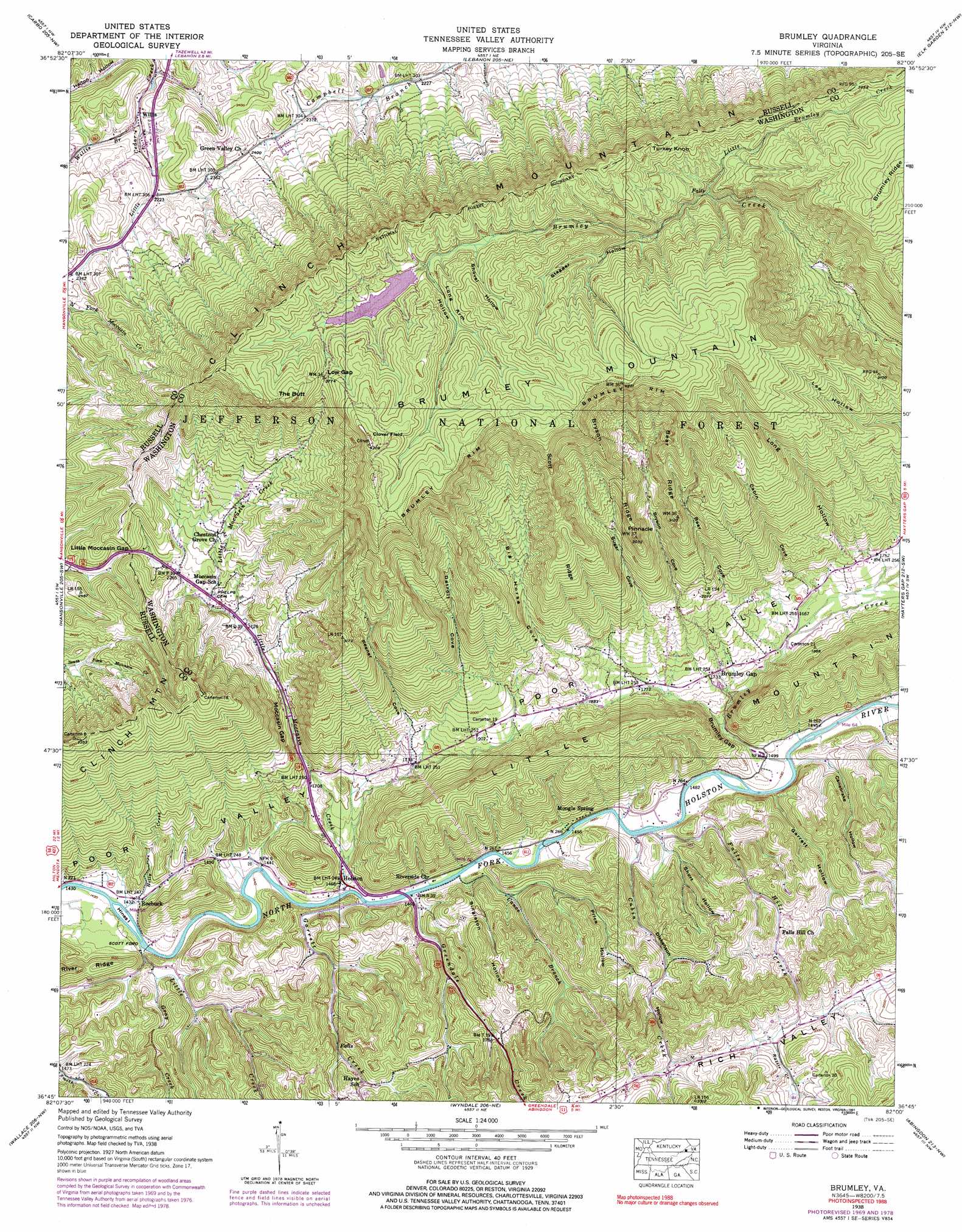
Brumley Topo Map Virginia
To zoom in, hover over the map of Brumley
USGS Topo Quad 36082g1 - 1:24,000 scale
| Topo Map Name: | Brumley |
| USGS Topo Quad ID: | 36082g1 |
| Print Size: | ca. 21 1/4" wide x 27" high |
| Southeast Coordinates: | 36.75° N latitude / 82° W longitude |
| Map Center Coordinates: | 36.8125° N latitude / 82.0625° W longitude |
| U.S. State: | VA |
| Filename: | o36082g1.jpg |
| Download Map JPG Image: | Brumley topo map 1:24,000 scale |
| Map Type: | Topographic |
| Topo Series: | 7.5´ |
| Map Scale: | 1:24,000 |
| Source of Map Images: | United States Geological Survey (USGS) |
| Alternate Map Versions: |
Brumley VA 1934 Download PDF Buy paper map Brumley VA 1938, updated 1965 Download PDF Buy paper map Brumley VA 1938, updated 1971 Download PDF Buy paper map Brumley VA 1938, updated 1978 Download PDF Buy paper map Brumley VA 1938, updated 1991 Download PDF Buy paper map Brumley VA 1939 Download PDF Buy paper map Brumley VA 1939 Download PDF Buy paper map Brumley VA 2011 Download PDF Buy paper map Brumley VA 2013 Download PDF Buy paper map Brumley VA 2016 Download PDF Buy paper map |
| FStopo: | US Forest Service topo Brumley is available: Download FStopo PDF Download FStopo TIF |
1:24,000 Topo Quads surrounding Brumley
Nora |
Duty |
Big A Mountain |
Honaker |
Richlands |
Saint Paul |
Carbo |
Lebanon |
Elk Garden |
Saltville |
Moll Creek |
Hansonville |
Brumley |
Hayters Gap |
Glade Spring |
Mendota |
Wallace |
Wyndale |
Abingdon |
Damascus |
Blountville |
Bristol |
Holston Valley |
Shady Valley |
Laurel Bloomery |
> Back to 36082e1 at 1:100,000 scale
> Back to 36082a1 at 1:250,000 scale
> Back to U.S. Topo Maps home
Brumley topo map: Gazetteer
Brumley: Bridges
Colonel Thomas McCulloch Memorial Bridge elevation 440m 1443′Brumley: Crossings
Scott Ford elevation 431m 1414′Brumley: Dams
Hidden Valley Lake Dam elevation 1089m 3572′Brumley: Flats
Clover Field elevation 1269m 4163′Brumley: Gaps
Brumley Gap elevation 471m 1545′Little Moccasin Gap elevation 727m 2385′
Low Gap elevation 1157m 3795′
Moccasin Gap elevation 561m 1840′
Brumley: Islands
Hines Island elevation 431m 1414′Brumley: Pillars
Pinnacle elevation 915m 3001′Brumley: Populated Places
Brumley Gap elevation 521m 1709′Holston elevation 448m 1469′
Mongle Spring elevation 459m 1505′
Roebuck elevation 438m 1437′
Willis elevation 675m 2214′
Brumley: Reservoirs
Hidden Valley Lake elevation 1089m 3572′Brumley: Ridges
Bear Ridge elevation 939m 3080′Brumley Rim elevation 1272m 4173′
Bryson Ridge elevation 939m 3080′
Scott Ridge elevation 1015m 3330′
Brumley: Streams
Brumley Creek elevation 451m 1479′Cabin Creek elevation 444m 1456′
Canoe Branch elevation 443m 1453′
Falls Hill Creek elevation 444m 1456′
Garrett Creek elevation 439m 1440′
Gray Creek elevation 443m 1453′
Greendale Creek elevation 440m 1443′
Holly Creek elevation 433m 1420′
Little Brumley Creek elevation 953m 3126′
Little Creek elevation 432m 1417′
Little Moccasin Creek elevation 439m 1440′
Rattle Creek elevation 578m 1896′
Willis Branch elevation 666m 2185′
Brumley: Summits
Brumley Mountain elevation 1141m 3743′The Butt elevation 1226m 4022′
Turkey Knob elevation 1101m 3612′
Brumley: Valleys
Bear Cove elevation 597m 1958′Big Horse Cove elevation 645m 2116′
Bryson Cove elevation 543m 1781′
Cabin Cove elevation 566m 1856′
Canebrake Hollow elevation 450m 1476′
Detroit Cove elevation 670m 2198′
Dickenson Hollow elevation 453m 1486′
Garrett Hollow elevation 447m 1466′
Kesner Cove elevation 565m 1853′
Long Arm Hollow elevation 1091m 3579′
Long Hollow elevation 570m 1870′
Possum Hollow elevation 535m 1755′
Price Hollow elevation 449m 1473′
Short Hollow elevation 457m 1499′
Shovel Hollow elevation 1088m 3569′
Singleton Hollow elevation 441m 1446′
Stagger Hollow elevation 989m 3244′
Sugar Cove elevation 612m 2007′
Brumley digital topo map on disk
Buy this Brumley topo map showing relief, roads, GPS coordinates and other geographical features, as a high-resolution digital map file on DVD:
Western Virginia & Southern West Virginia
Buy digital topo maps: Western Virginia & Southern West Virginia