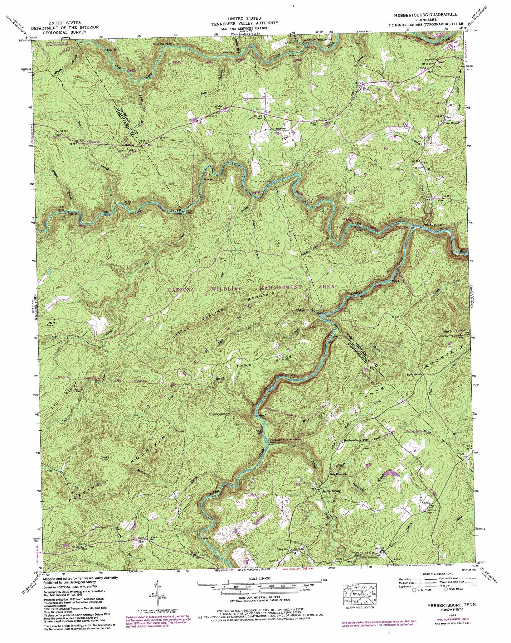
Hebbertsburg Topo Map Tennessee
To zoom in, hover over the map of Hebbertsburg
USGS Topo Quad 36084a7 - 1:24,000 scale
| Topo Map Name: | Hebbertsburg |
| USGS Topo Quad ID: | 36084a7 |
| Print Size: | ca. 21 1/4" wide x 27" high |
| Southeast Coordinates: | 36° N latitude / 84.75° W longitude |
| Map Center Coordinates: | 36.0625° N latitude / 84.8125° W longitude |
| U.S. State: | TN |
| Filename: | o36084a7.jpg |
| Download Map JPG Image: | Hebbertsburg topo map 1:24,000 scale |
| Map Type: | Topographic |
| Topo Series: | 7.5´ |
| Map Scale: | 1:24,000 |
| Source of Map Images: | United States Geological Survey (USGS) |
| Alternate Map Versions: |
Hebbertsburg TN 1936 Download PDF Buy paper map Hebbertsburg TN 1943, updated 1957 Download PDF Buy paper map Hebbertsburg TN 1943, updated 1966 Download PDF Buy paper map Hebbertsburg TN 1943, updated 1968 Download PDF Buy paper map Hebbertsburg TN 1943, updated 1977 Download PDF Buy paper map Hebbertsburg TN 1943, updated 1980 Download PDF Buy paper map Hebbertsburg TN 1945 Download PDF Buy paper map Hebbertsburg TN 2010 Download PDF Buy paper map Hebbertsburg TN 2013 Download PDF Buy paper map Hebbertsburg TN 2016 Download PDF Buy paper map |
1:24,000 Topo Quads surrounding Hebbertsburg
Wilder |
Grimsley |
Burrville |
Rugby |
Robbins |
Clarkrange |
Jones Knob |
Twin Bridges |
Pilot Mountain |
Gobey |
Isoline |
Fox Creek |
Hebbertsburg |
Lancing |
Camp Austin |
Crossville |
Dorton |
Ozone |
Cardiff |
Harriman |
Vandever |
Grassy Cove |
Roddy |
Rockwood |
Bacon Gap |
> Back to 36084a1 at 1:100,000 scale
> Back to 36084a1 at 1:250,000 scale
> Back to U.S. Topo Maps home
Hebbertsburg topo map: Gazetteer
Hebbertsburg: Bridges
Waltman Ford Bridge elevation 356m 1167′Hebbertsburg: Crossings
Hegler Ford elevation 374m 1227′Mouth of Yellow Creek Ford elevation 408m 1338′
Potter Ford elevation 361m 1184′
Waltman Ford elevation 355m 1164′
Hebbertsburg: Falls
Double Drop Falls elevation 363m 1190′Hebbertsburg: Parks
Obed Wild and Scenic River elevation 331m 1085′Hebbertsburg: Populated Places
Berkshire Forest elevation 548m 1797′Frankfort elevation 447m 1466′
Halfway elevation 501m 1643′
Hebbertsburg elevation 474m 1555′
Holland Ford elevation 372m 1220′
Obed Junction elevation 334m 1095′
Hebbertsburg: Post Offices
Hebbertsburg Post Office (historical) elevation 521m 1709′Hebbertsburg: Ridges
Hawn Ridge elevation 516m 1692′Lick Ridge elevation 527m 1729′
Hebbertsburg: Springs
Dripping Spring elevation 524m 1719′Hebbertsburg: Streams
Brady Branch elevation 360m 1181′Buck Creek elevation 462m 1515′
Cove Branch elevation 407m 1335′
Daddys Creek elevation 331m 1085′
Davis Branch elevation 486m 1594′
Grandaddy Branch elevation 469m 1538′
Hawn Branch elevation 506m 1660′
Hawn Spring Branch elevation 375m 1230′
Hegler Branch elevation 381m 1250′
Lick Creek elevation 502m 1646′
Little Buck Creek elevation 451m 1479′
Little Cove Branch elevation 359m 1177′
Long Branch elevation 377m 1236′
McGinnis Branch elevation 414m 1358′
Middle Branch elevation 391m 1282′
Mill Branch elevation 363m 1190′
Mill Creek Branch elevation 345m 1131′
Muddy Branch elevation 382m 1253′
Otter Creek elevation 382m 1253′
Pole Pen Branch elevation 370m 1213′
Polecat Branch elevation 389m 1276′
Qualls Spring Branch elevation 348m 1141′
Ramsey Creek elevation 332m 1089′
Rogers Creek elevation 486m 1594′
Staples Spring Branch elevation 356m 1167′
Tom Branch elevation 390m 1279′
White Creek elevation 364m 1194′
Yellow Creek elevation 409m 1341′
Hebbertsburg: Summits
Little Peavine Mountain elevation 579m 1899′Peavine Mountain elevation 643m 2109′
Pilot Knob elevation 625m 2050′
Pilot Knob Mountain elevation 621m 2037′
Hebbertsburg digital topo map on disk
Buy this Hebbertsburg topo map showing relief, roads, GPS coordinates and other geographical features, as a high-resolution digital map file on DVD: