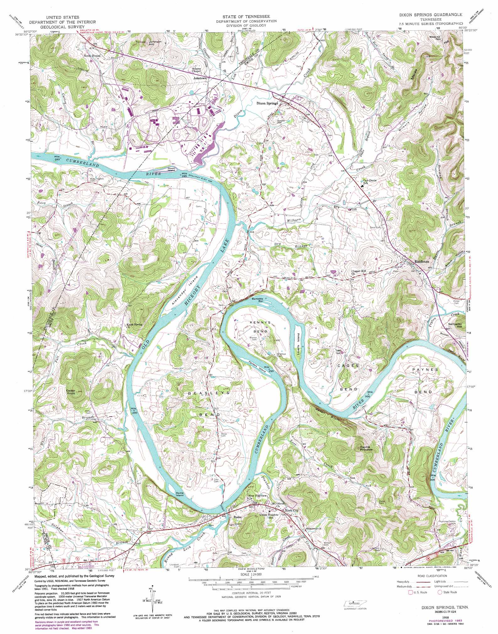
Dixon Springs Topo Map Tennessee
To zoom in, hover over the map of Dixon Springs
USGS Topo Quad 36086c1 - 1:24,000 scale
| Topo Map Name: | Dixon Springs |
| USGS Topo Quad ID: | 36086c1 |
| Print Size: | ca. 21 1/4" wide x 27" high |
| Southeast Coordinates: | 36.25° N latitude / 86° W longitude |
| Map Center Coordinates: | 36.3125° N latitude / 86.0625° W longitude |
| U.S. State: | TN |
| Filename: | o36086c1.jpg |
| Download Map JPG Image: | Dixon Springs topo map 1:24,000 scale |
| Map Type: | Topographic |
| Topo Series: | 7.5´ |
| Map Scale: | 1:24,000 |
| Source of Map Images: | United States Geological Survey (USGS) |
| Alternate Map Versions: |
Dixon Springs TN 1958, updated 1959 Download PDF Buy paper map Dixon Springs TN 1958, updated 1959 Download PDF Buy paper map Dixon Springs TN 1958, updated 1979 Download PDF Buy paper map Dixon Springs TN 1958, updated 1983 Download PDF Buy paper map Dixon Springs TN 1994, updated 1997 Download PDF Buy paper map Dixon Springs TN 2010 Download PDF Buy paper map Dixon Springs TN 2013 Download PDF Buy paper map Dixon Springs TN 2016 Download PDF Buy paper map |
1:24,000 Topo Quads surrounding Dixon Springs
Turners Station |
Westmoreland |
Lafayette |
Galen |
Red Boiling Springs |
Bethpage |
Hartsville |
Hillsdale |
Pleasant Shade |
Willette |
Hunters Point |
Bellwood |
Dixon Springs |
Carthage |
Granville |
Lebanon |
Shop Springs |
New Middleton |
Gordonsville |
Buffalo Valley |
Vine |
Watertown |
Alexandria |
Liberty |
Center Hill Dam |
> Back to 36086a1 at 1:100,000 scale
> Back to 36086a1 at 1:250,000 scale
> Back to U.S. Topo Maps home
Dixon Springs topo map: Gazetteer
Dixon Springs: Bars
Bartletts Bar elevation 136m 446′Cotton Bar elevation 136m 446′
Rowlands Towhead elevation 136m 446′
Dixon Springs: Bends
Beasleys Bend elevation 175m 574′Cages Bend elevation 168m 551′
Kennys Bend elevation 149m 488′
Paynes Bend elevation 152m 498′
Dixon Springs: Cliffs
Scraunchers Rock Bluff elevation 142m 465′Upton Bluff elevation 192m 629′
Dixon Springs: Crossings
Rome Ferry elevation 136m 446′Dixon Springs: Dams
Old Lock and Dam Number Seven (historical) elevation 136m 446′Dixon Springs: Islands
Alexander Island elevation 140m 459′Blind Island elevation 138m 452′
Dixon Island elevation 139m 456′
Lovells Island elevation 140m 459′
Parkers Island elevation 136m 446′
Rome Island elevation 136m 446′
Dixon Springs: Parks
Rome Access Area elevation 139m 456′Dixon Springs: Pillars
Haynie Pinnacle elevation 306m 1003′Dixon Springs: Populated Places
Dixon Springs elevation 144m 472′Johntown elevation 152m 498′
Riddleton elevation 160m 524′
Rock City elevation 149m 488′
Rock House elevation 168m 551′
Rome elevation 147m 482′
Dixon Springs: Post Offices
Dixon Springs Post Office elevation 143m 469′Riddleton Post Office elevation 155m 508′
Dixon Springs: Streams
Bowman Branch elevation 159m 521′Corley Branch elevation 140m 459′
Davis Branch elevation 142m 465′
Dixon Creek elevation 136m 446′
Dry Branch elevation 135m 442′
Dry Fork Branch elevation 144m 472′
Duke Branch elevation 150m 492′
Fall Creek elevation 139m 456′
Glasgow Branch elevation 140m 459′
Lick Creek elevation 137m 449′
Lost Creek elevation 137m 449′
Peyton Creek elevation 140m 459′
Plunkett Creek elevation 140m 459′
Rawls Creek elevation 147m 482′
Round Lick Creek elevation 147m 482′
Sulphur Branch elevation 139m 456′
Taylors Branch elevation 140m 459′
Ward Creek elevation 138m 452′
White Branch elevation 136m 446′
Wilburn Creek elevation 138m 452′
Young Branch elevation 146m 479′
Dixon Springs: Summits
Cedar Knob elevation 270m 885′Johnson Hill elevation 295m 967′
Maces Hill elevation 326m 1069′
Saltpeter Hill elevation 227m 744′
Dixon Springs: Valleys
Boston Hollow elevation 146m 479′Brimm Hollow elevation 145m 475′
Wilburn Hollow elevation 158m 518′
Dixon Springs digital topo map on disk
Buy this Dixon Springs topo map showing relief, roads, GPS coordinates and other geographical features, as a high-resolution digital map file on DVD: