Point Pleasant Topo Map Missouri
To zoom in, hover over the map of Point Pleasant
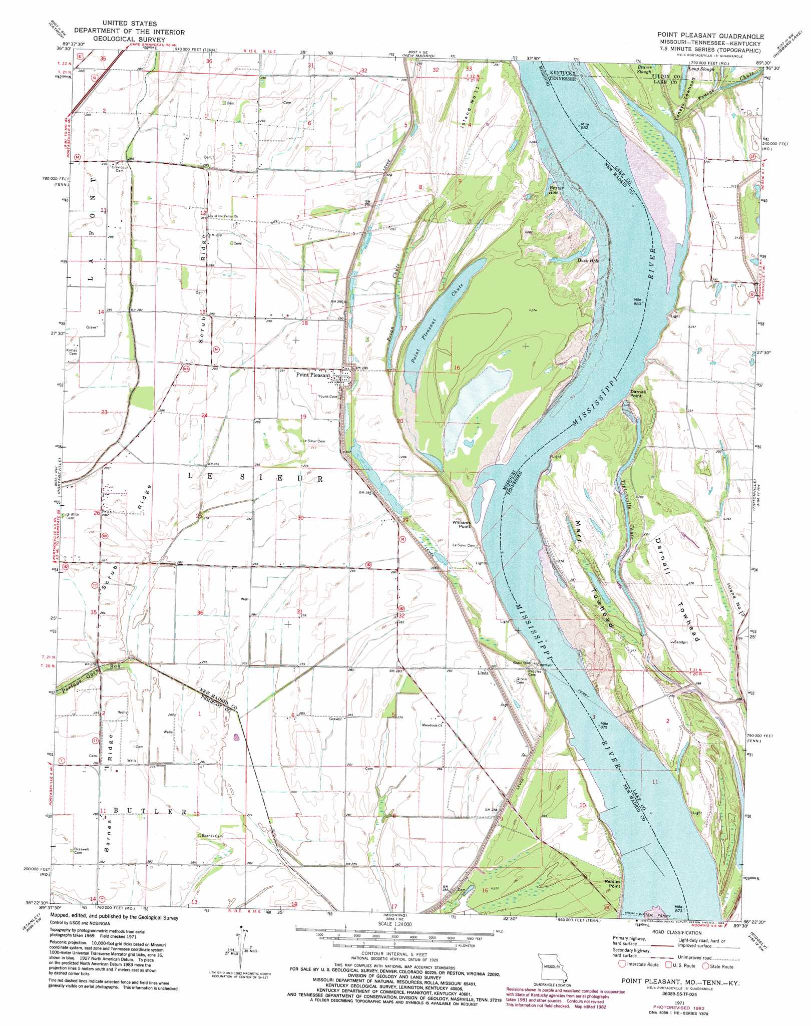
USGS Topo Quad 36089d5 - 1:24,000 scale
| Topo Map Name: | Point Pleasant |
| USGS Topo Quad ID: | 36089d5 |
| Print Size: | ca. 21 1/4" wide x 27" high |
| Southeast Coordinates: | 36.375° N latitude / 89.5° W longitude |
| Map Center Coordinates: | 36.4375° N latitude / 89.5625° W longitude |
| U.S. States: | MO, TN, KY |
| Filename: | o36089d5.jpg |
| Download Map JPG Image: | Point Pleasant topo map 1:24,000 scale |
| Map Type: | Topographic |
| Topo Series: | 7.5´ |
| Map Scale: | 1:24,000 |
| Source of Map Images: | United States Geological Survey (USGS) |
| Alternate Map Versions: |
Point Pleasant MO 1971, updated 1973 Download PDF Buy paper map Point Pleasant MO 1971, updated 1983 Download PDF Buy paper map Point Pleasant MO 2010 Download PDF Buy paper map Point Pleasant MO 2012 Download PDF Buy paper map Point Pleasant MO 2015 Download PDF Buy paper map |
1:24,000 Topo Quads surrounding Point Pleasant
Hills Store |
Charter Oak |
Kewanee |
Henderson Mound |
Bayouville |
Parma |
Catron |
New Madrid |
Hubbard Lake |
Bondurant |
Boekerton |
Portageville |
Point Pleasant |
Tiptonville |
Samburg |
Wardell |
Stanley |
Mooring |
Ridgely |
Hornbeak |
Hayti Heights |
Caruthersville |
Tennemo |
Miston |
Lane |
> Back to 36089a1 at 1:100,000 scale
> Back to 36088a1 at 1:250,000 scale
> Back to U.S. Topo Maps home
Point Pleasant topo map: Gazetteer
Point Pleasant: Areas
Island Number 11 elevation 87m 285′Point Pleasant: Bars
Bixby Towhead elevation 86m 282′Darnall Towhead elevation 88m 288′
Linda Bar elevation 86m 282′
Marr Field Bar elevation 85m 278′
Marr Towhead elevation 85m 278′
Narr Towhead elevation 86m 282′
Nolan Bar elevation 82m 269′
Tiptonville Towhead elevation 86m 282′
Toneys Towhead elevation 85m 278′
Point Pleasant: Bays
Beaver Hole elevation 83m 272′Duck Hole elevation 84m 275′
Point Pleasant: Capes
Riddles Point elevation 79m 259′Slough Landing Neck elevation 91m 298′
Williams Point elevation 84m 275′
Point Pleasant: Channels
Toneys Chute elevation 85m 278′Point Pleasant: Cliffs
Darnall Point elevation 85m 278′Point Pleasant: Crossings
Tiptonville Ferry elevation 78m 255′Point Pleasant: Guts
Long Slough elevation 85m 278′Long Slough elevation 85m 278′
Pecan Chute elevation 84m 275′
Tiptonville Chute elevation 83m 272′
Point Pleasant: Lakes
Cushion Lake (historical) elevation 82m 269′Point Pleasant Chute elevation 82m 269′
Point Pleasant: Levees
Below Toneys Towhead Revetment elevation 83m 272′Point Pleasant: Populated Places
Linda elevation 88m 288′Point Pleasant elevation 87m 285′
Point Pleasant: Ridges
Barnes Ridge elevation 86m 282′Scrub Ridge elevation 89m 291′
Point Pleasant: Streams
Toneys Chute elevation 82m 269′Toneys Chute elevation 82m 269′
Point Pleasant digital topo map on disk
Buy this Point Pleasant topo map showing relief, roads, GPS coordinates and other geographical features, as a high-resolution digital map file on DVD: