Le Fevre Ridge Topo Map Arizona
To zoom in, hover over the map of Le Fevre Ridge
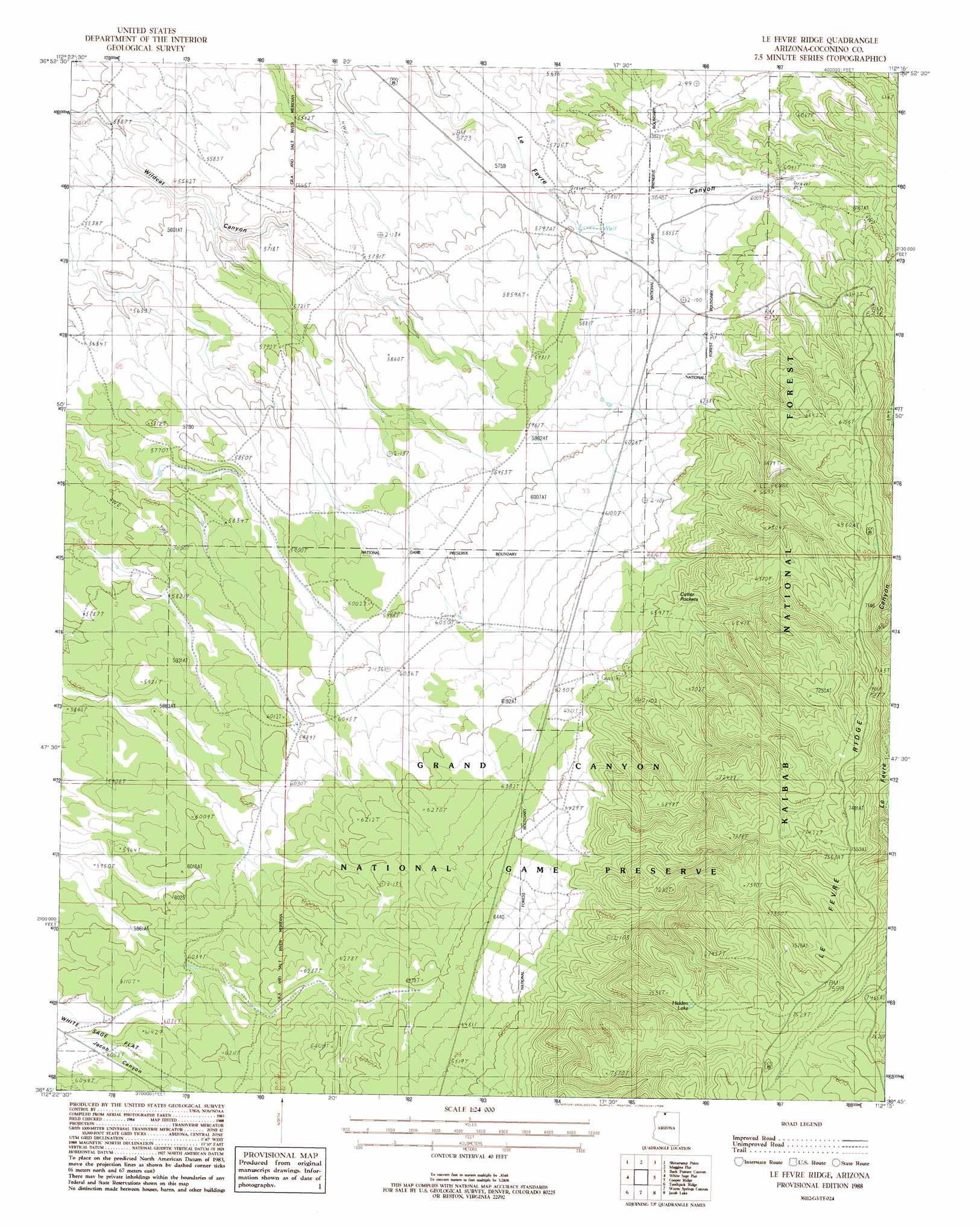
USGS Topo Quad 36112g3 - 1:24,000 scale
| Topo Map Name: | Le Fevre Ridge |
| USGS Topo Quad ID: | 36112g3 |
| Print Size: | ca. 21 1/4" wide x 27" high |
| Southeast Coordinates: | 36.75° N latitude / 112.25° W longitude |
| Map Center Coordinates: | 36.8125° N latitude / 112.3125° W longitude |
| U.S. State: | AZ |
| Filename: | o36112g3.jpg |
| Download Map JPG Image: | Le Fevre Ridge topo map 1:24,000 scale |
| Map Type: | Topographic |
| Topo Series: | 7.5´ |
| Map Scale: | 1:24,000 |
| Source of Map Images: | United States Geological Survey (USGS) |
| Alternate Map Versions: |
Shinarump SE AZ 1957, updated 1958 Download PDF Buy paper map Le Fevre Ridge AZ 1988, updated 1988 Download PDF Buy paper map Le Fevre Ridge AZ 2012 Download PDF Buy paper map Le Fevre Ridge AZ 2014 Download PDF Buy paper map |
| FStopo: | US Forest Service topo Le Fevre Ridge is available: Download FStopo PDF Download FStopo TIF |
1:24,000 Topo Quads surrounding Le Fevre Ridge
Kanab |
Thompson Point |
Johnson Lakes |
Petrified Hollow |
Pine Hollow Canyon |
Fredonia |
Shinarump Point |
Muggins Flat |
Buck Pasture Canyon |
Coyote Buttes |
Clear Water Spring |
White Sage Flat |
Le Fevre Ridge |
Cooper Ridge |
House Rock Spring |
Gunsight Point |
Toothpick Ridge |
Warm Springs Canyon |
Jacob Lake |
House Rock |
Jumpup Point |
Sowats Spring |
Big Springs |
Telephone Hill |
Cane |
> Back to 36112e1 at 1:100,000 scale
> Back to 36112a1 at 1:250,000 scale
> Back to U.S. Topo Maps home
Le Fevre Ridge topo map: Gazetteer
Le Fevre Ridge: Basins
Cutler Pockets elevation 1966m 6450′Wittis Gravel Pit elevation 1837m 6026′
Le Fevre Ridge: Lakes
Hidden Lake elevation 2279m 7477′Le Fevre Ridge: Reservoirs
Cutler Pockets Trick Tank elevation 1972m 6469′Cutler Pockets Wildlife Apron elevation 1903m 6243′
Cutler Pockets Wildlife Apron elevation 1906m 6253′
Dickie Tank elevation 1848m 6062′
Fence Line Tank elevation 2221m 7286′
Gravel Pit Tank elevation 1856m 6089′
Henrie Tank elevation 1879m 6164′
Highway Tank elevation 2258m 7408′
Judd Tank elevation 1922m 6305′
Overlook Tanks elevation 2150m 7053′
Le Fevre Ridge: Ridges
Lefevre Ridge elevation 2286m 7500′Le Fevre Ridge digital topo map on disk
Buy this Le Fevre Ridge topo map showing relief, roads, GPS coordinates and other geographical features, as a high-resolution digital map file on DVD: