San Felipe Topo Map California
To zoom in, hover over the map of San Felipe
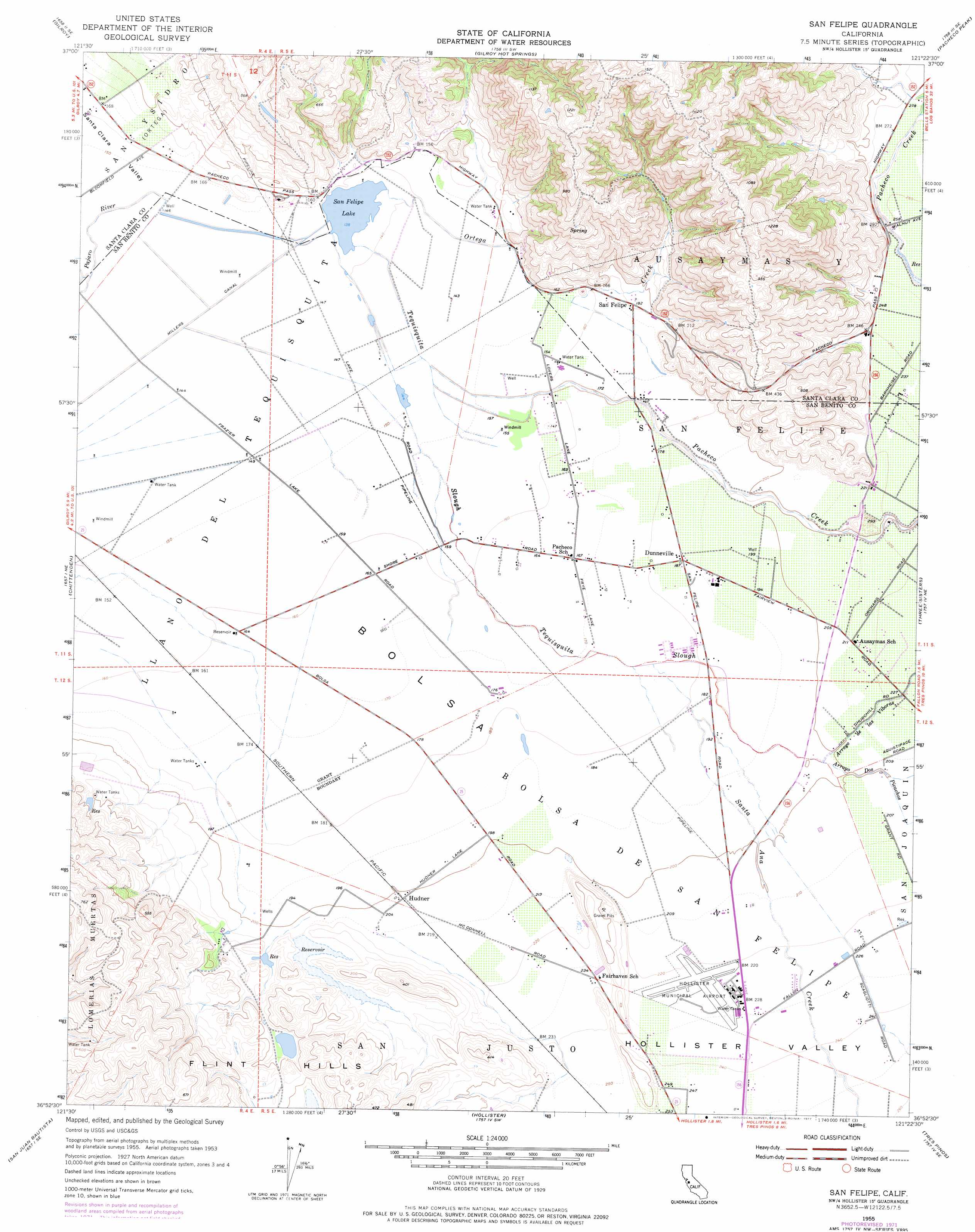
USGS Topo Quad 36121h4 - 1:24,000 scale
| Topo Map Name: | San Felipe |
| USGS Topo Quad ID: | 36121h4 |
| Print Size: | ca. 21 1/4" wide x 27" high |
| Southeast Coordinates: | 36.875° N latitude / 121.375° W longitude |
| Map Center Coordinates: | 36.9375° N latitude / 121.4375° W longitude |
| U.S. State: | CA |
| Filename: | o36121h4.jpg |
| Download Map JPG Image: | San Felipe topo map 1:24,000 scale |
| Map Type: | Topographic |
| Topo Series: | 7.5´ |
| Map Scale: | 1:24,000 |
| Source of Map Images: | United States Geological Survey (USGS) |
| Alternate Map Versions: |
San Felipe CA 1955, updated 1956 Download PDF Buy paper map San Felipe CA 1955, updated 1968 Download PDF Buy paper map San Felipe CA 1955, updated 1972 Download PDF Buy paper map San Felipe CA 1955, updated 1977 Download PDF Buy paper map San Felipe CA 2012 Download PDF Buy paper map San Felipe CA 2015 Download PDF Buy paper map |
1:24,000 Topo Quads surrounding San Felipe
Morgan Hill |
Mount Sizer |
Mississippi Creek |
Mustang Peak |
Crevison Peak |
Mount Madonna |
Gilroy |
Gilroy Hot Springs |
Pacheco Peak |
Pacheco Pass |
Watsonville East |
Chittenden |
San Felipe |
Three Sisters |
Mariposa Peak |
Prunedale |
San Juan Bautista |
Hollister |
Tres Pinos |
Quien Sabe Valley |
Salinas |
Natividad |
Mount Harlan |
Paicines |
Cherry Peak |
> Back to 36121e1 at 1:100,000 scale
> Back to 36120a1 at 1:250,000 scale
> Back to U.S. Topo Maps home
San Felipe topo map: Gazetteer
San Felipe: Airports
Frazier Lake Airpark elevation 46m 150′Hollister Municipal Airport elevation 69m 226′
San Felipe: Areas
Bolsa elevation 53m 173′San Felipe: Canals
Millers Canal elevation 44m 144′San Felipe: Dams
Vessey 654 Dam elevation 71m 232′San Felipe: Lakes
San Felipe Lake elevation 43m 141′San Felipe: Parks
Hollister Wayside Park elevation 72m 236′San Felipe: Populated Places
Dunneville elevation 58m 190′Hudner elevation 63m 206′
San Felipe elevation 56m 183′
San Felipe: Streams
Arroyo De Las Viboras elevation 60m 196′Arroyo Dos Picachos elevation 60m 196′
Ortega Creek elevation 43m 141′
Pacheco Creek elevation 43m 141′
Santa Ana Creek elevation 54m 177′
Tequisquita Slough elevation 43m 141′
San Felipe: Summits
Flint Hills elevation 102m 334′San Felipe: Valleys
Hollister Valley elevation 58m 190′San Felipe digital topo map on disk
Buy this San Felipe topo map showing relief, roads, GPS coordinates and other geographical features, as a high-resolution digital map file on DVD: