Morgan Hill Topo Map California
To zoom in, hover over the map of Morgan Hill
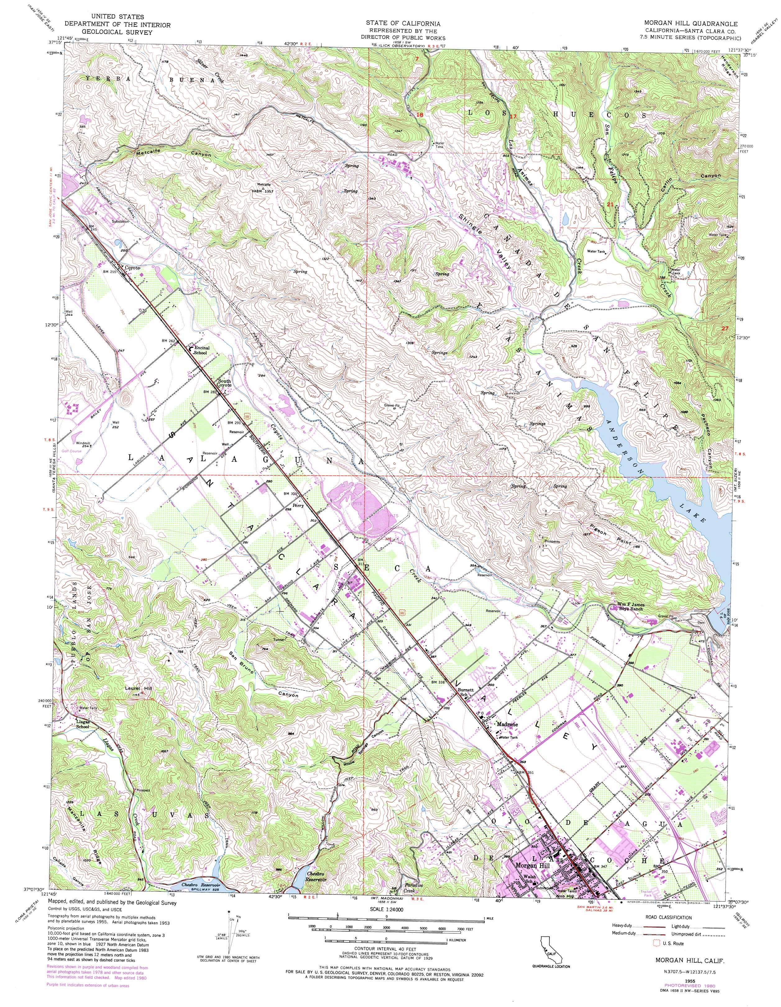
USGS Topo Quad 37121b6 - 1:24,000 scale
| Topo Map Name: | Morgan Hill |
| USGS Topo Quad ID: | 37121b6 |
| Print Size: | ca. 21 1/4" wide x 27" high |
| Southeast Coordinates: | 37.125° N latitude / 121.625° W longitude |
| Map Center Coordinates: | 37.1875° N latitude / 121.6875° W longitude |
| U.S. State: | CA |
| Filename: | o37121b6.jpg |
| Download Map JPG Image: | Morgan Hill topo map 1:24,000 scale |
| Map Type: | Topographic |
| Topo Series: | 7.5´ |
| Map Scale: | 1:24,000 |
| Source of Map Images: | United States Geological Survey (USGS) |
| Alternate Map Versions: |
Morgan Hill CA 1955, updated 1956 Download PDF Buy paper map Morgan Hill CA 1955, updated 1961 Download PDF Buy paper map Morgan Hill CA 1955, updated 1969 Download PDF Buy paper map Morgan Hill CA 1955, updated 1975 Download PDF Buy paper map Morgan Hill CA 1955, updated 1980 Download PDF Buy paper map Morgan Hill CA 1955, updated 1980 Download PDF Buy paper map Morgan Hill CA 2012 Download PDF Buy paper map Morgan Hill CA 2015 Download PDF Buy paper map |
1:24,000 Topo Quads surrounding Morgan Hill
Milpitas |
Calaveras Reservoir |
Mount Day |
Eylar Mountain |
Mount Boardman |
San Jose West |
San Jose East |
Lick Observatory |
Isabel Valley |
Mount Stakes |
Los Gatos |
Santa Teresa Hills |
Morgan Hill |
Mount Sizer |
Mississippi Creek |
Laurel |
Loma Prieta |
Mount Madonna |
Gilroy |
Gilroy Hot Springs |
Soquel |
Watsonville West |
Watsonville East |
Chittenden |
San Felipe |
> Back to 37121a1 at 1:100,000 scale
> Back to 37120a1 at 1:250,000 scale
> Back to U.S. Topo Maps home
Morgan Hill topo map: Gazetteer
Morgan Hill: Capes
Pigeon Point elevation 385m 1263′Morgan Hill: Crossings
Exit 366 elevation 109m 357′Exit 367 elevation 116m 380′
Morgan Hill: Dams
Leroy Anderson 72-009 Dam elevation 190m 623′Morgan Hill: Parks
Anderson Lake County Park elevation 190m 623′Britton Field elevation 108m 354′
Del Monte Park elevation 108m 354′
Field Sports County Park elevation 121m 396′
Galvan Park elevation 107m 351′
Motorcycle County Park elevation 417m 1368′
Murphy Springs Park elevation 117m 383′
Morgan Hill: Populated Places
Coyote elevation 75m 246′Madrone elevation 107m 351′
Morgan Hill elevation 108m 354′
Perry elevation 92m 301′
South Coyote elevation 86m 282′
Morgan Hill: Post Offices
Coyote Post Office elevation 75m 246′Morgan Hill: Reservoirs
Anderson Lake elevation 190m 623′Morgan Hill: Ridges
Henderson Ridge elevation 707m 2319′Manzanita Ridge elevation 372m 1220′
Morgan Hill: Streams
Las Animas Creek elevation 191m 626′San Felipe Creek elevation 196m 643′
Morgan Hill: Summits
Laurel Hill elevation 336m 1102′Morgan Hill: Valleys
Carlin Canyon elevation 233m 764′Metcalfe Canyon elevation 85m 278′
Pacheco Canyon elevation 190m 623′
San Bruno Canyon elevation 96m 314′
Shingle Valley elevation 196m 643′
Willow Springs Canyon elevation 102m 334′
Morgan Hill digital topo map on disk
Buy this Morgan Hill topo map showing relief, roads, GPS coordinates and other geographical features, as a high-resolution digital map file on DVD: