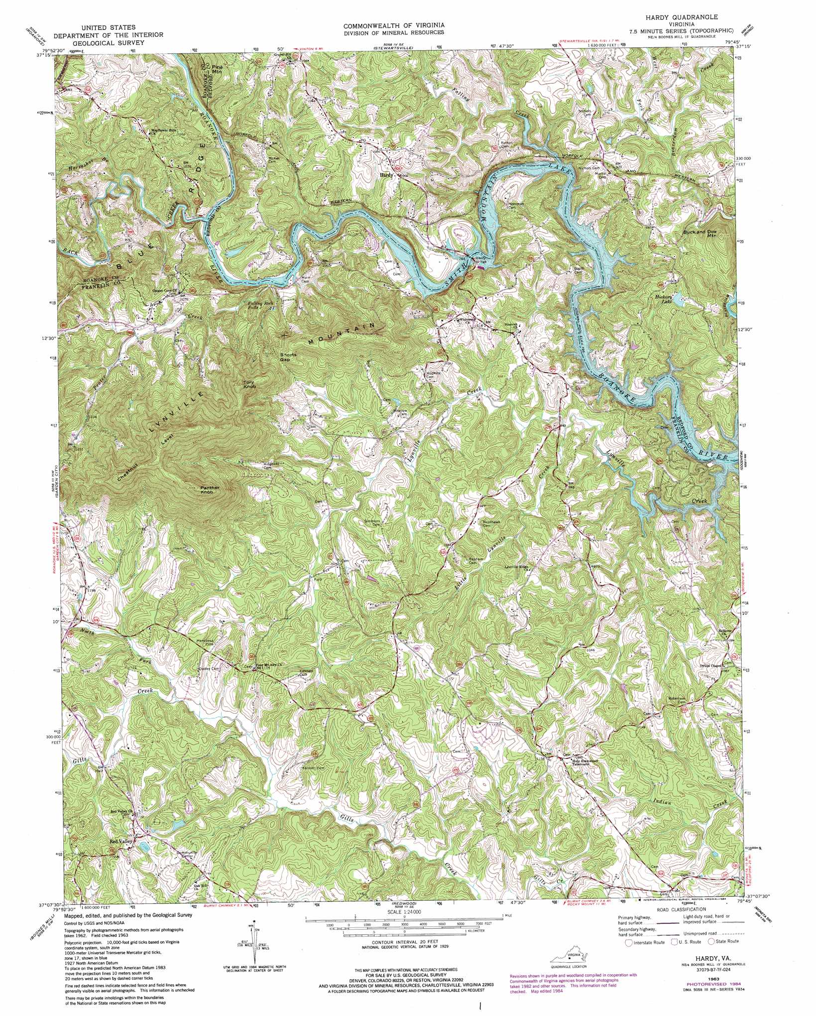
Hardy Topo Map Virginia
To zoom in, hover over the map of Hardy
USGS Topo Quad 37079b7 - 1:24,000 scale
| Topo Map Name: | Hardy |
| USGS Topo Quad ID: | 37079b7 |
| Print Size: | ca. 21 1/4" wide x 27" high |
| Southeast Coordinates: | 37.125° N latitude / 79.75° W longitude |
| Map Center Coordinates: | 37.1875° N latitude / 79.8125° W longitude |
| U.S. State: | VA |
| Filename: | o37079b7.jpg |
| Download Map JPG Image: | Hardy topo map 1:24,000 scale |
| Map Type: | Topographic |
| Topo Series: | 7.5´ |
| Map Scale: | 1:24,000 |
| Source of Map Images: | United States Geological Survey (USGS) |
| Alternate Map Versions: |
Hardy VA 1963 Download PDF Buy paper map Hardy VA 1963, updated 1965 Download PDF Buy paper map Hardy VA 1963, updated 1984 Download PDF Buy paper map Hardy VA 2011 Download PDF Buy paper map Hardy VA 2013 Download PDF Buy paper map Hardy VA 2016 Download PDF Buy paper map |
1:24,000 Topo Quads surrounding Hardy
Catawba |
Daleville |
Villamont |
Montvale |
Peaks Of Otter |
Salem |
Roanoke |
Stewartsville |
Irving |
Bedford |
Bent Mountain |
Garden City |
Hardy |
Goodview |
Moneta |
Callaway |
Boones Mill |
Redwood |
Moneta Sw |
Smith Mountain Dam |
Ferrum |
Rocky Mount |
Gladehill |
Penhook |
Sandy Level |
> Back to 37079a1 at 1:100,000 scale
> Back to 37078a1 at 1:250,000 scale
> Back to U.S. Topo Maps home
Hardy topo map: Gazetteer
Hardy: Bridges
Hardy Bridge elevation 242m 793′Hardy: Crossings
Blackwater Ford elevation 242m 793′Hardys Ford elevation 242m 793′
Horns Ford elevation 242m 793′
Lynville Ford elevation 242m 793′
McVeighs Ford elevation 243m 797′
Webbs Ford elevation 242m 793′
Hardy: Dams
Little Falling River Number One Dam elevation 300m 984′Hardy: Falls
Falling Rock Falls elevation 258m 846′Hardy: Gaps
Shorts Gap elevation 368m 1207′Hardy: Populated Places
Coopers Cove elevation 305m 1000′Hardy elevation 304m 997′
Hardy Ford elevation 311m 1020′
Mayflower Hills elevation 311m 1020′
Red Valley elevation 369m 1210′
Wyatt (historical) elevation 338m 1108′
Hardy: Reservoirs
Clearview Lake elevation 300m 984′Hickory Lake elevation 279m 915′
Hardy: Ridges
Chestnut Level elevation 614m 2014′Hardy: Streams
Back Creek elevation 244m 800′Big Branch elevation 242m 793′
Falling Creek elevation 251m 823′
Horseshoe Branch elevation 251m 823′
Little Lynville Creek elevation 250m 820′
Lynville Creek elevation 242m 793′
North Fork Gills Creek elevation 304m 997′
Prater Creek elevation 242m 793′
West Fork Beaverdam Creek elevation 254m 833′
Hardy: Summits
Buck and Doe Mountain elevation 373m 1223′Lynville Mountain elevation 407m 1335′
Panther Knob elevation 621m 2037′
Pine Mountain elevation 405m 1328′
Tory Knob elevation 541m 1774′
Hardy digital topo map on disk
Buy this Hardy topo map showing relief, roads, GPS coordinates and other geographical features, as a high-resolution digital map file on DVD:
Western Virginia & Southern West Virginia
Buy digital topo maps: Western Virginia & Southern West Virginia