Clintwood Topo Map Virginia
To zoom in, hover over the map of Clintwood
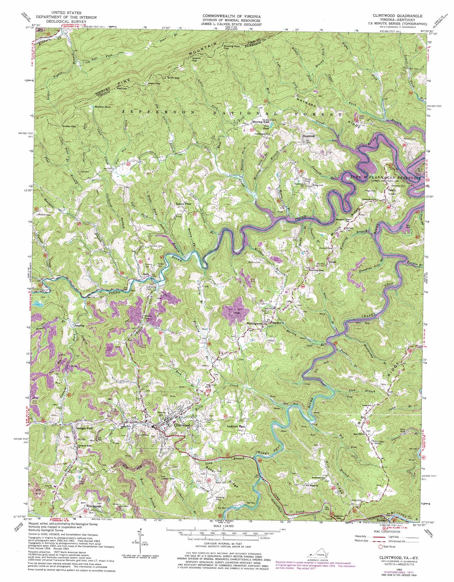
USGS Topo Quad 37082b4 - 1:24,000 scale
| Topo Map Name: | Clintwood |
| USGS Topo Quad ID: | 37082b4 |
| Print Size: | ca. 21 1/4" wide x 27" high |
| Southeast Coordinates: | 37.125° N latitude / 82.375° W longitude |
| Map Center Coordinates: | 37.1875° N latitude / 82.4375° W longitude |
| U.S. States: | VA, KY |
| Filename: | o37082b4.jpg |
| Download Map JPG Image: | Clintwood topo map 1:24,000 scale |
| Map Type: | Topographic |
| Topo Series: | 7.5´ |
| Map Scale: | 1:24,000 |
| Source of Map Images: | United States Geological Survey (USGS) |
| Alternate Map Versions: |
Clintwood VA 1954, updated 1955 Download PDF Buy paper map Clintwood VA 1954, updated 1955 Download PDF Buy paper map Clintwood VA 1963, updated 1965 Download PDF Buy paper map Clintwood VA 1963, updated 1978 Download PDF Buy paper map Clintwood VA 2011 Download PDF Buy paper map Clintwood VA 2013 Download PDF Buy paper map Clintwood VA 2016 Download PDF Buy paper map |
| FStopo: | US Forest Service topo Clintwood is available: Download FStopo PDF Download FStopo TIF |
1:24,000 Topo Quads surrounding Clintwood
Mcdowell |
Pikeville |
Millard |
Lick Creek |
Jamboree |
Wheelwright |
Dorton |
Hellier |
Elkhorn City |
Harman |
Jenkins West |
Jenkins East |
Clintwood |
Haysi |
Prater |
Flat Gap |
Pound |
Caney Ridge |
Nora |
Duty |
Norton |
Wise |
Coeburn |
Saint Paul |
Carbo |
> Back to 37082a1 at 1:100,000 scale
> Back to 37082a1 at 1:250,000 scale
> Back to U.S. Topo Maps home
Clintwood topo map: Gazetteer
Clintwood: Dams
Nicewonder Dam elevation 463m 1519′Clintwood: Gaps
Birch Gap elevation 939m 3080′Birch Gap elevation 932m 3057′
Blowing Rock Gap elevation 823m 2700′
Dutton Gap elevation 832m 2729′
Dutton Gap elevation 831m 2726′
Flat Gap elevation 845m 2772′
Flat Gap elevation 845m 2772′
Grassy Gap elevation 793m 2601′
Grassy Gap elevation 788m 2585′
Jesse Gap elevation 798m 2618′
Jesse Gap elevation 794m 2604′
Nichols Gap elevation 587m 1925′
Clintwood: Populated Places
Blowing Rock elevation 563m 1847′Clintwood elevation 535m 1755′
Dwale elevation 610m 2001′
Flemingtown elevation 544m 1784′
Freeling elevation 454m 1489′
Fremont elevation 443m 1453′
Georges Fork elevation 469m 1538′
Huckleberry (historical) elevation 557m 1827′
Isom elevation 453m 1486′
Lockhart Flats elevation 594m 1948′
Millard elevation 664m 2178′
Ramsey Flats elevation 550m 1804′
Skeetrock elevation 566m 1856′
Tandy elevation 573m 1879′
Clintwood: Reservoirs
Cow Pond elevation 531m 1742′Mullins Pond elevation 746m 2447′
Clintwood: Ridges
Baker Ridge elevation 599m 1965′Big Ridge elevation 604m 1981′
Hill Ridge elevation 642m 2106′
Maynard Ridge elevation 538m 1765′
Mullins Ridge elevation 525m 1722′
Clintwood: Streams
Bartley Branch elevation 421m 1381′Bearpen Branch elevation 439m 1440′
Big Branch elevation 435m 1427′
Blowing Fork elevation 435m 1427′
Brush Creek elevation 437m 1433′
Brushy Fork elevation 538m 1765′
Camp Creek elevation 442m 1450′
Cane Creek elevation 421m 1381′
Childress Branch elevation 461m 1512′
Cranes Nest River elevation 422m 1384′
Cutter Creek elevation 443m 1453′
Doeface Branch elevation 421m 1381′
East Fork Cane Creek elevation 458m 1502′
Fishtrap Branch elevation 421m 1381′
Flat Gap Branch elevation 556m 1824′
Fleming Branch elevation 465m 1525′
Georges Fork elevation 439m 1440′
Holly Creek elevation 435m 1427′
Honeycamp Branch elevation 421m 1381′
Howell Branch elevation 455m 1492′
Jerry Branch elevation 435m 1427′
Jim Senter Branch elevation 508m 1666′
Laurel Branch elevation 430m 1410′
Laurel Creek elevation 469m 1538′
Left Fork Laurel Branch elevation 473m 1551′
Left Fork Lower Pigeon Branch elevation 402m 1318′
Left Fork Upper Twin Branch elevation 522m 1712′
Lick Branch elevation 430m 1410′
Little Fork elevation 529m 1735′
Little Laurel Branch elevation 421m 1381′
Little Pine Branch elevation 567m 1860′
Long Branch elevation 439m 1440′
Lower Pigeon Branch elevation 361m 1184′
Meadow Branch elevation 432m 1417′
Middle Fork Upper Twin Branch elevation 522m 1712′
Mill Creek elevation 421m 1381′
Moore Branch elevation 421m 1381′
Neel Branch elevation 421m 1381′
Pine Branch elevation 567m 1860′
Pine Creek elevation 444m 1456′
Poplar Branch elevation 421m 1381′
Pounding Tree Branch elevation 421m 1381′
Ramsey Fork elevation 429m 1407′
Right Fork Laurel Branch elevation 473m 1551′
Right Fork Upper Twin Branch elevation 422m 1384′
Rock Branch elevation 500m 1640′
Rocky Branch elevation 421m 1381′
Star Branch elevation 437m 1433′
Tanbark Branch elevation 421m 1381′
Tarpon Branch elevation 421m 1381′
Wolfpen Branch elevation 421m 1381′
Clintwood: Tunnels
Bearpen Gap Tunnel elevation 579m 1899′Clintwood: Valleys
Pond Hollow elevation 424m 1391′Clintwood digital topo map on disk
Buy this Clintwood topo map showing relief, roads, GPS coordinates and other geographical features, as a high-resolution digital map file on DVD:
Western Virginia & Southern West Virginia
Buy digital topo maps: Western Virginia & Southern West Virginia