Jenkins East Topo Map Virginia
To zoom in, hover over the map of Jenkins East
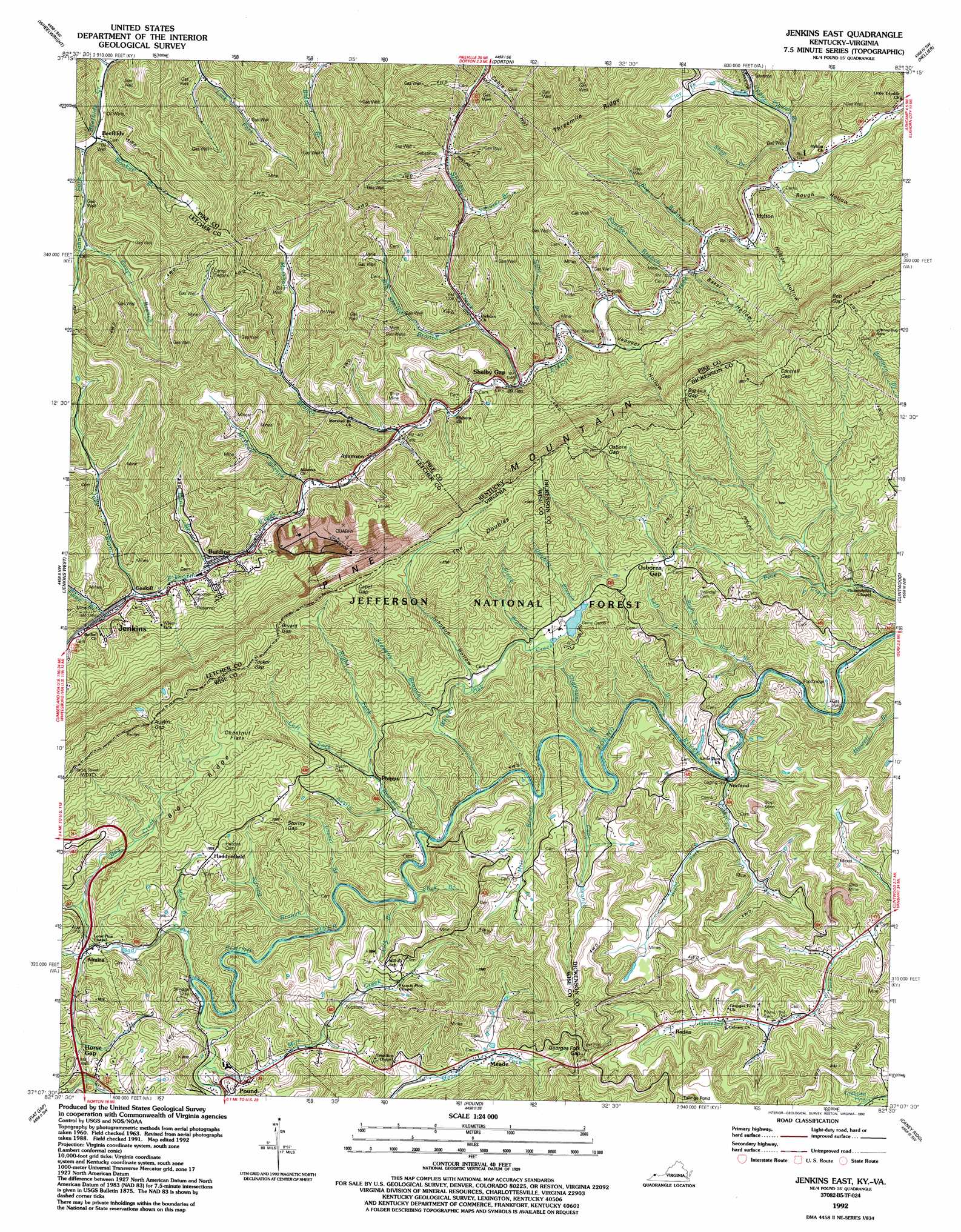
USGS Topo Quad 37082b5 - 1:24,000 scale
| Topo Map Name: | Jenkins East |
| USGS Topo Quad ID: | 37082b5 |
| Print Size: | ca. 21 1/4" wide x 27" high |
| Southeast Coordinates: | 37.125° N latitude / 82.5° W longitude |
| Map Center Coordinates: | 37.1875° N latitude / 82.5625° W longitude |
| U.S. States: | VA, KY |
| Filename: | o37082b5.jpg |
| Download Map JPG Image: | Jenkins East topo map 1:24,000 scale |
| Map Type: | Topographic |
| Topo Series: | 7.5´ |
| Map Scale: | 1:24,000 |
| Source of Map Images: | United States Geological Survey (USGS) |
| Alternate Map Versions: |
Jenkins East KY 1954, updated 1955 Download PDF Buy paper map Jenkins East KY 1963, updated 1965 Download PDF Buy paper map Jenkins East KY 1963, updated 1973 Download PDF Buy paper map Jenkins East KY 1963, updated 1978 Download PDF Buy paper map Jenkins East KY 1992, updated 1992 Download PDF Buy paper map Jenkins East KY 2011 Download PDF Buy paper map Jenkins East KY 2013 Download PDF Buy paper map Jenkins East KY 2016 Download PDF Buy paper map |
| FStopo: | US Forest Service topo Jenkins East is available: Download FStopo PDF Download FStopo TIF |
1:24,000 Topo Quads surrounding Jenkins East
Wayland |
Mcdowell |
Pikeville |
Millard |
Lick Creek |
Kite |
Wheelwright |
Dorton |
Hellier |
Elkhorn City |
Mayking |
Jenkins West |
Jenkins East |
Clintwood |
Haysi |
Whitesburg |
Flat Gap |
Pound |
Caney Ridge |
Nora |
Appalachia |
Norton |
Wise |
Coeburn |
Saint Paul |
> Back to 37082a1 at 1:100,000 scale
> Back to 37082a1 at 1:250,000 scale
> Back to U.S. Topo Maps home
Jenkins East topo map: Gazetteer
Jenkins East: Bridges
Point Twenty Eight Bridge Railroad Stop (historical) elevation 426m 1397′Jenkins East: Dams
Moss Number One Fresh Water Supply Dam elevation 599m 1965′White Oak Creek Dam elevation 518m 1699′
Jenkins East: Flats
Chestnut Flats elevation 703m 2306′Jenkins East: Gaps
Austin Gap elevation 841m 2759′Austin Gap elevation 845m 2772′
Big Lick Gap elevation 785m 2575′
Big Lick Gap elevation 790m 2591′
Bob Gap elevation 843m 2765′
Bob Gap elevation 849m 2785′
Bryant Gap elevation 806m 2644′
Bryant Gap elevation 796m 2611′
Cable Gap elevation 795m 2608′
Cantrell Gap elevation 755m 2477′
Cantrell Gap elevation 751m 2463′
Georges Fork Gap elevation 645m 2116′
Osborn Gap elevation 809m 2654′
Osborn Gap elevation 796m 2611′
Shelby Gap elevation 414m 1358′
Stormy Gap elevation 608m 1994′
Tucker Gap elevation 805m 2641′
Tucker Gap elevation 806m 2644′
Jenkins East: Pillars
Johnny Bug Rock elevation 792m 2598′Jenkins East: Populated Places
Adamson elevation 440m 1443′Almira elevation 498m 1633′
Baden elevation 497m 1630′
Burdine elevation 452m 1482′
East Jenkins elevation 445m 1459′
Gaskill elevation 454m 1489′
Haddonfield elevation 579m 1899′
Hylton elevation 379m 1243′
Lick Fork elevation 386m 1266′
Marshall Branch elevation 457m 1499′
Meade elevation 519m 1702′
Mill Creek elevation 501m 1643′
Norland elevation 449m 1473′
Phipps elevation 477m 1564′
Jenkins East: Post Offices
Burdine Post Office (historical) elevation 440m 1443′Democracy Post Office (historical) elevation 434m 1423′
Hyton Post Office (historical) elevation 450m 1476′
Jewell Post Office (historical) elevation 438m 1437′
Ore Knob Post Office (historical) elevation 510m 1673′
Shelby Gap Post Office (historical) elevation 412m 1351′
Jenkins East: Ranges
Pine Mountain elevation 678m 2224′Jenkins East: Ridges
Big Ridge elevation 690m 2263′Threemile Ridge elevation 689m 2260′
Jenkins East: Streams
Anderson Branch elevation 402m 1318′Austin Branch elevation 463m 1519′
Bad Creek elevation 469m 1538′
Bear Fork elevation 342m 1122′
Bearpen Creek elevation 460m 1509′
Bens Branch elevation 442m 1450′
Big Branch elevation 384m 1259′
Big Branch elevation 485m 1591′
Big Shelby Branch elevation 425m 1394′
Booker Branch elevation 359m 1177′
Camp Creek elevation 449m 1473′
Cane Branch elevation 454m 1489′
Cane Branch elevation 457m 1499′
Cane Branch elevation 412m 1351′
Clay Fork elevation 453m 1486′
Doubles Branch elevation 524m 1719′
Elkhorn Creek elevation 362m 1187′
Grays Branch elevation 426m 1397′
Joes Branch elevation 451m 1479′
Johns Fork elevation 361m 1184′
Killen Branch elevation 459m 1505′
Laurel Branch elevation 462m 1515′
Laurel Fork elevation 412m 1351′
Left Fork Bearpen Creek elevation 491m 1610′
Left Fork Big Branch elevation 485m 1591′
Left Fork Camp Creek elevation 461m 1512′
Lick Branch elevation 462m 1515′
Little Potter Branch elevation 441m 1446′
Marshall Branch elevation 421m 1381′
McPeak Branch elevation 434m 1423′
Mill Branch elevation 457m 1499′
Mill Creek elevation 475m 1558′
Mud Branch elevation 475m 1558′
Oldhouse Branch elevation 451m 1479′
Panther Branch elevation 387m 1269′
Right Fork Bearpen Creek elevation 491m 1610′
Right Fork Big Branch elevation 485m 1591′
Right Fork Camp Creek elevation 461m 1512′
Shop Branch elevation 388m 1272′
Slick Branch elevation 466m 1528′
Spring Branch elevation 463m 1519′
Stevens Branch elevation 475m 1558′
Stone Branch elevation 518m 1699′
Upper Pigeon Branch elevation 379m 1243′
Vanover Branch elevation 389m 1276′
White Oak Creek elevation 460m 1509′
Jenkins East: Summits
The Doubles elevation 757m 2483′Jenkins East: Trails
Pine Mountain Trail elevation 791m 2595′Jenkins East: Valleys
Baker Hollow elevation 387m 1269′Cable Hollow elevation 373m 1223′
Hylton Hollow elevation 392m 1286′
Johnson Hollow elevation 514m 1686′
Rough Hollow elevation 379m 1243′
Vanover Hollow elevation 409m 1341′
Jenkins East digital topo map on disk
Buy this Jenkins East topo map showing relief, roads, GPS coordinates and other geographical features, as a high-resolution digital map file on DVD:
Western Virginia & Southern West Virginia
Buy digital topo maps: Western Virginia & Southern West Virginia