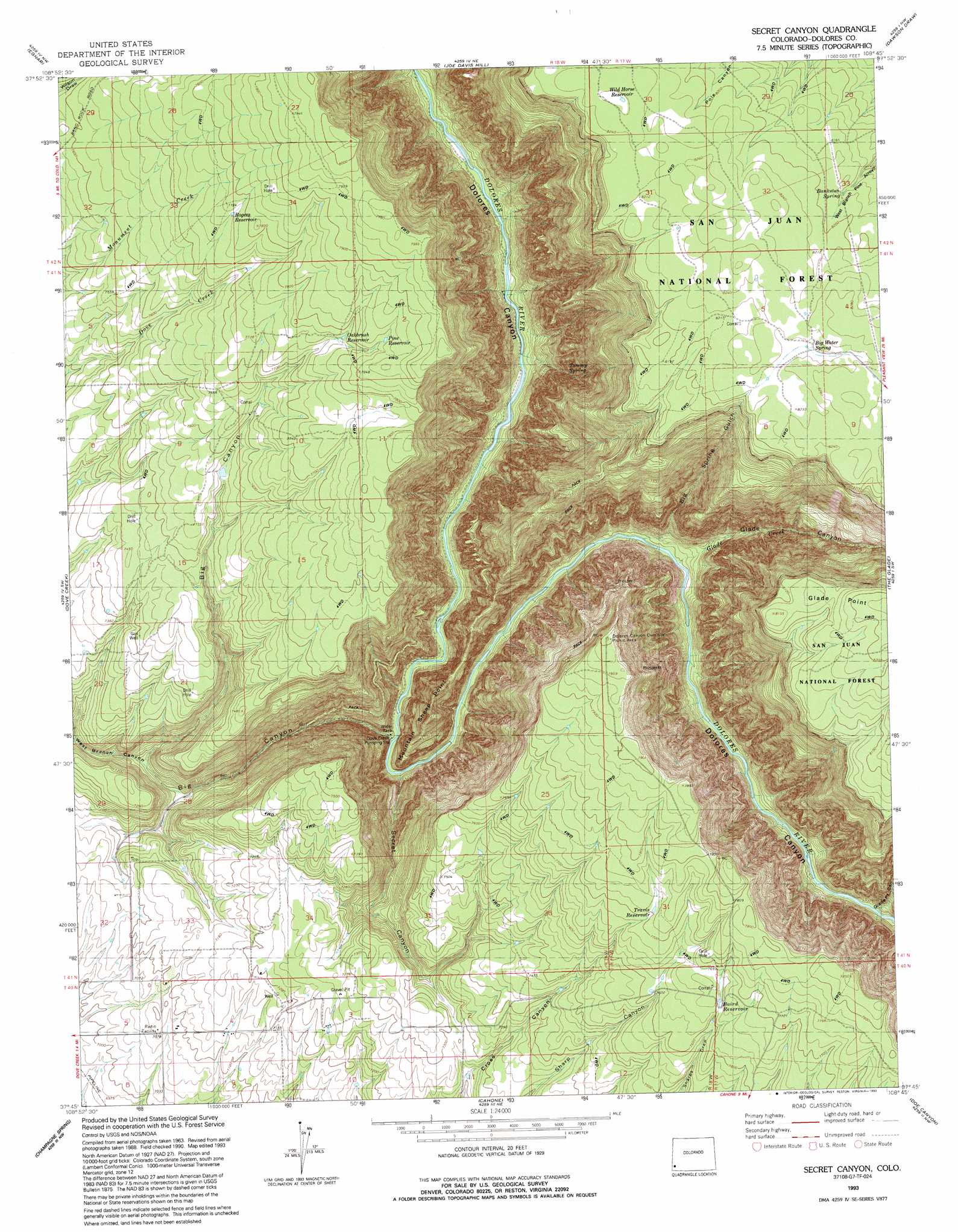
Secret Canyon Topo Map Colorado
To zoom in, hover over the map of Secret Canyon
USGS Topo Quad 37108g7 - 1:24,000 scale
| Topo Map Name: | Secret Canyon |
| USGS Topo Quad ID: | 37108g7 |
| Print Size: | ca. 21 1/4" wide x 27" high |
| Southeast Coordinates: | 37.75° N latitude / 108.75° W longitude |
| Map Center Coordinates: | 37.8125° N latitude / 108.8125° W longitude |
| U.S. State: | CO |
| Filename: | o37108g7.jpg |
| Download Map JPG Image: | Secret Canyon topo map 1:24,000 scale |
| Map Type: | Topographic |
| Topo Series: | 7.5´ |
| Map Scale: | 1:24,000 |
| Source of Map Images: | United States Geological Survey (USGS) |
| Alternate Map Versions: |
Secret Canyon CO 1964, updated 1968 Download PDF Buy paper map Secret Canyon CO 1964, updated 1968 Download PDF Buy paper map Secret Canyon CO 1993, updated 1993 Download PDF Buy paper map Secret Canyon CO 2011 Download PDF Buy paper map Secret Canyon CO 2013 Download PDF Buy paper map Secret Canyon CO 2016 Download PDF Buy paper map |
| FStopo: | US Forest Service topo Secret Canyon is available: Download FStopo PDF Download FStopo TIF |
1:24,000 Topo Quads surrounding Secret Canyon
Summit Point |
Horse Range Mesa |
Hamm Canyon |
Gypsum Gap |
Basin |
Piute Point |
Egnar |
Joe Davis Hill |
Dawson Draw |
Mckenna Peak |
Northdale |
Dove Creek |
Secret Canyon |
The Glade |
Glade Mountain |
Burnt Cabin Creek |
Champagne Spring |
Cahone |
Doe Canyon |
Narraguinnep Mountain |
Papoose Canyon |
Ruin Canyon |
Pleasant View |
Yellow Jacket |
Trimble Point |
> Back to 37108e1 at 1:100,000 scale
> Back to 37108a1 at 1:250,000 scale
> Back to U.S. Topo Maps home
Secret Canyon topo map: Gazetteer
Secret Canyon: Capes
Mountain Sheep Point elevation 2163m 7096′Secret Canyon: Mines
Arrowhead Mine elevation 2171m 7122′Glade Canyon Prospect elevation 2239m 7345′
Pack Rat Mine elevation 2305m 7562′
Rainy Day Mine elevation 2286m 7500′
Secret Canyon: Reservoirs
Baird Reservoir elevation 2329m 7641′Big Water Reservoir Number Eight elevation 2522m 8274′
Big Water Reservoir Number One elevation 2513m 8244′
Big Water Reservoir Number Thirteen elevation 2510m 8234′
Dalton Reservoir elevation 2395m 7857′
Oakbrush Reservoir elevation 2369m 7772′
Overlook Reservoir Number One elevation 2363m 7752′
Pine Reservoir elevation 2390m 7841′
Pole Canyon Reservoir Number One elevation 2484m 8149′
Rogers Reservoir elevation 2366m 7762′
Travis Reservoir elevation 2350m 7709′
Wild Bill Reservoir Number Eight elevation 2456m 8057′
Wild Bill Reservoir Number One elevation 2461m 8074′
Wild Horse Reservoir elevation 2513m 8244′
Secret Canyon: Springs
Bankston Spring elevation 2489m 8166′Big Water Spring elevation 2512m 8241′
Tommy Spring elevation 2006m 6581′
Secret Canyon: Streams
Glade Creek elevation 1923m 6309′Secret Canyon: Valleys
Big Canyon elevation 1863m 6112′Big Spring Gulch elevation 1917m 6289′
Glade Canyon elevation 1910m 6266′
Glade Point Canyon elevation 1932m 6338′
Secret Canyon elevation 1870m 6135′
West Branch Big Canyon elevation 2118m 6948′
Secret Canyon digital topo map on disk
Buy this Secret Canyon topo map showing relief, roads, GPS coordinates and other geographical features, as a high-resolution digital map file on DVD: