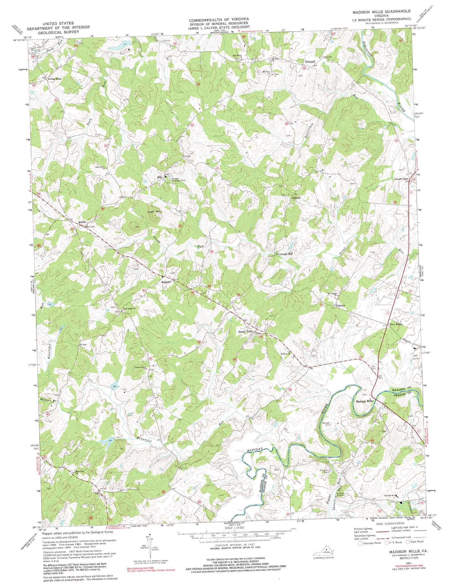
Madison Mills Topo Map Virginia
To zoom in, hover over the map of Madison Mills
USGS Topo Quad 38078c2 - 1:24,000 scale
| Topo Map Name: | Madison Mills |
| USGS Topo Quad ID: | 38078c2 |
| Print Size: | ca. 21 1/4" wide x 27" high |
| Southeast Coordinates: | 38.25° N latitude / 78.125° W longitude |
| Map Center Coordinates: | 38.3125° N latitude / 78.1875° W longitude |
| U.S. State: | VA |
| Filename: | o38078c2.jpg |
| Download Map JPG Image: | Madison Mills topo map 1:24,000 scale |
| Map Type: | Topographic |
| Topo Series: | 7.5´ |
| Map Scale: | 1:24,000 |
| Source of Map Images: | United States Geological Survey (USGS) |
| Alternate Map Versions: |
Madison Mills VA 1971, updated 1972 Download PDF Buy paper map Madison Mills VA 1971, updated 1984 Download PDF Buy paper map Madison Mills VA 1971, updated 1991 Download PDF Buy paper map Madison Mills VA 2010 Download PDF Buy paper map Madison Mills VA 2013 Download PDF Buy paper map Madison Mills VA 2016 Download PDF Buy paper map |
1:24,000 Topo Quads surrounding Madison Mills
Big Meadows |
Old Rag Mountain |
Woodville |
Castleton |
Brandy Station |
Fletcher |
Madison |
Brightwood |
Culpeper West |
Culpeper East |
Stanardsville |
Rochelle |
Madison Mills |
Rapidan |
Unionville |
Earlysville |
Barboursville |
Gordonsville |
Orange |
Lahore |
Charlottesville East |
Keswick |
Boswells Tavern |
Louisa |
Mineral |
> Back to 38078a1 at 1:100,000 scale
> Back to 38078a1 at 1:250,000 scale
> Back to U.S. Topo Maps home
Madison Mills topo map: Gazetteer
Madison Mills: Dams
Beautiful Run Number 10 Dam elevation 132m 433′Beautiful Run Number 11 Dam elevation 151m 495′
Beautiful Run Number Five Dam elevation 138m 452′
Beautiful Run Number Four Dam elevation 145m 475′
Beautiful Run Number Seven Dam elevation 131m 429′
Beautiful Run Number Six Dam elevation 134m 439′
Malvern Dam elevation 132m 433′
Madison Mills: Populated Places
Achash elevation 160m 524′Aroda elevation 181m 593′
Burnt Tree elevation 153m 501′
Elly elevation 193m 633′
Five Forks elevation 126m 413′
Locust Dale elevation 120m 393′
Madison Mills elevation 99m 324′
Oakpark elevation 150m 492′
Radiant elevation 164m 538′
Tanners elevation 144m 472′
Twymans Mill elevation 113m 370′
Uno elevation 160m 524′
Madison Mills: Reservoirs
Malvern Lake elevation 132m 433′Madison Mills: Streams
Beautiful Run elevation 100m 328′Laurel Run elevation 107m 351′
Poplar Run elevation 97m 318′
Skinner Branch elevation 126m 413′
Madison Mills: Summits
Lost Mountain elevation 233m 764′Madison Mills digital topo map on disk
Buy this Madison Mills topo map showing relief, roads, GPS coordinates and other geographical features, as a high-resolution digital map file on DVD:
Western Virginia & Southern West Virginia
Buy digital topo maps: Western Virginia & Southern West Virginia