Fork Mountain Topo Map West Virginia
To zoom in, hover over the map of Fork Mountain
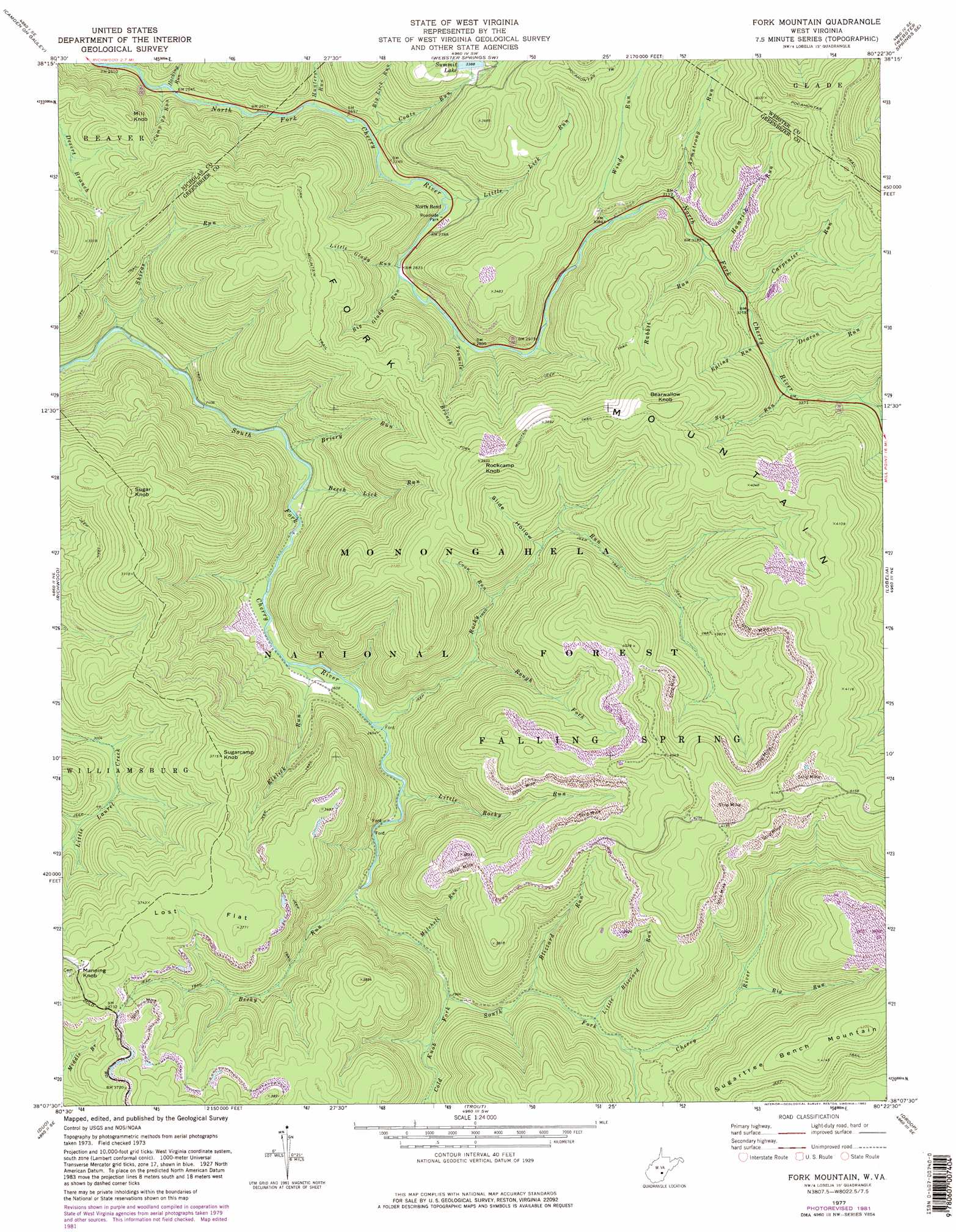
USGS Topo Quad 38080b4 - 1:24,000 scale
| Topo Map Name: | Fork Mountain |
| USGS Topo Quad ID: | 38080b4 |
| Print Size: | ca. 21 1/4" wide x 27" high |
| Southeast Coordinates: | 38.125° N latitude / 80.375° W longitude |
| Map Center Coordinates: | 38.1875° N latitude / 80.4375° W longitude |
| U.S. State: | WV |
| Filename: | o38080b4.jpg |
| Download Map JPG Image: | Fork Mountain topo map 1:24,000 scale |
| Map Type: | Topographic |
| Topo Series: | 7.5´ |
| Map Scale: | 1:24,000 |
| Source of Map Images: | United States Geological Survey (USGS) |
| Alternate Map Versions: |
Fork Mountain WV 1977, updated 1978 Download PDF Buy paper map Fork Mountain WV 1977, updated 1982 Download PDF Buy paper map Fork Mountain WV 1995, updated 1998 Download PDF Buy paper map Fork Mountain WV 2011 Download PDF Buy paper map Fork Mountain WV 2014 Download PDF Buy paper map Fork Mountain WV 2016 Download PDF Buy paper map |
| FStopo: | US Forest Service topo Fork Mountain is available: Download FStopo PDF Download FStopo TIF |
1:24,000 Topo Quads surrounding Fork Mountain
Tioga |
Cowen |
Webster Springs |
Bergoo |
Sharp Knob |
Craigsville |
Camden On Gauley |
Webster Springs Sw |
Webster Springs Se |
Woodrow |
Nettie |
Richwood |
Fork Mountain |
Lobelia |
Hillsboro |
Quinwood |
Duo |
Trout |
Droop |
Denmar |
Rupert |
Cornstalk |
Williamsburg |
Anthony |
Alvon |
> Back to 38080a1 at 1:100,000 scale
> Back to 38080a1 at 1:250,000 scale
> Back to U.S. Topo Maps home
Fork Mountain topo map: Gazetteer
Fork Mountain: Dams
Summit Lake Dam elevation 1032m 3385′Fork Mountain: Flats
Lost Flat elevation 1130m 3707′Fork Mountain: Populated Places
North Bend elevation 851m 2791′Fork Mountain: Reservoirs
Summit Lake elevation 1033m 3389′Fork Mountain: Streams
Armstrong Run elevation 958m 3143′Becky Run elevation 859m 2818′
Beech Lick Run elevation 754m 2473′
Big Glady Run elevation 860m 2821′
Big Lick Run elevation 829m 2719′
Big Run elevation 985m 3231′
Big Run elevation 986m 3234′
Blizzard Run elevation 934m 3064′
Briery Run elevation 750m 2460′
Bumblebee Run elevation 937m 3074′
Camp 29 Run elevation 772m 2532′
Carpenter Run elevation 977m 3205′
Coats Run elevation 824m 2703′
Cold Knob Fork elevation 904m 2965′
Coon Run elevation 921m 3021′
Deacon Run elevation 988m 3241′
Elklick Run elevation 789m 2588′
Epling Run elevation 986m 3234′
Fallen Timber Run elevation 998m 3274′
Hacking Run elevation 775m 2542′
Hamrick Run elevation 963m 3159′
Hunters Run elevation 805m 2641′
Little Blizzard Run elevation 946m 3103′
Little Glady Run elevation 859m 2818′
Little Lick Run elevation 840m 2755′
Little Rocky Run elevation 825m 2706′
Mitchell Run elevation 885m 2903′
Rabbit Run elevation 963m 3159′
Rocky Run elevation 803m 2634′
Rough Fork elevation 873m 2864′
Shiras Run elevation 718m 2355′
Tenmile Branch elevation 874m 2867′
Windy Run elevation 936m 3070′
Fork Mountain: Summits
Bearwallow Knob elevation 1227m 4025′Fork Mountain elevation 1271m 4169′
Manning Knob elevation 1210m 3969′
Mill Knob elevation 978m 3208′
Rockcamp Knob elevation 1187m 3894′
Sugar Knob elevation 1165m 3822′
Sugarcamp Knob elevation 1132m 3713′
Sugartree Bench Mountain elevation 1289m 4229′
Fork Mountain: Trails
Big Run Trail elevation 1075m 3526′Fork Mountain Trail elevation 1107m 3631′
Pocahontas Trail elevation 1171m 3841′
Fork Mountain: Valleys
Slide Hollow elevation 982m 3221′Fork Mountain digital topo map on disk
Buy this Fork Mountain topo map showing relief, roads, GPS coordinates and other geographical features, as a high-resolution digital map file on DVD:
Western Virginia & Southern West Virginia
Buy digital topo maps: Western Virginia & Southern West Virginia