Mount Alto Topo Map West Virginia
To zoom in, hover over the map of Mount Alto
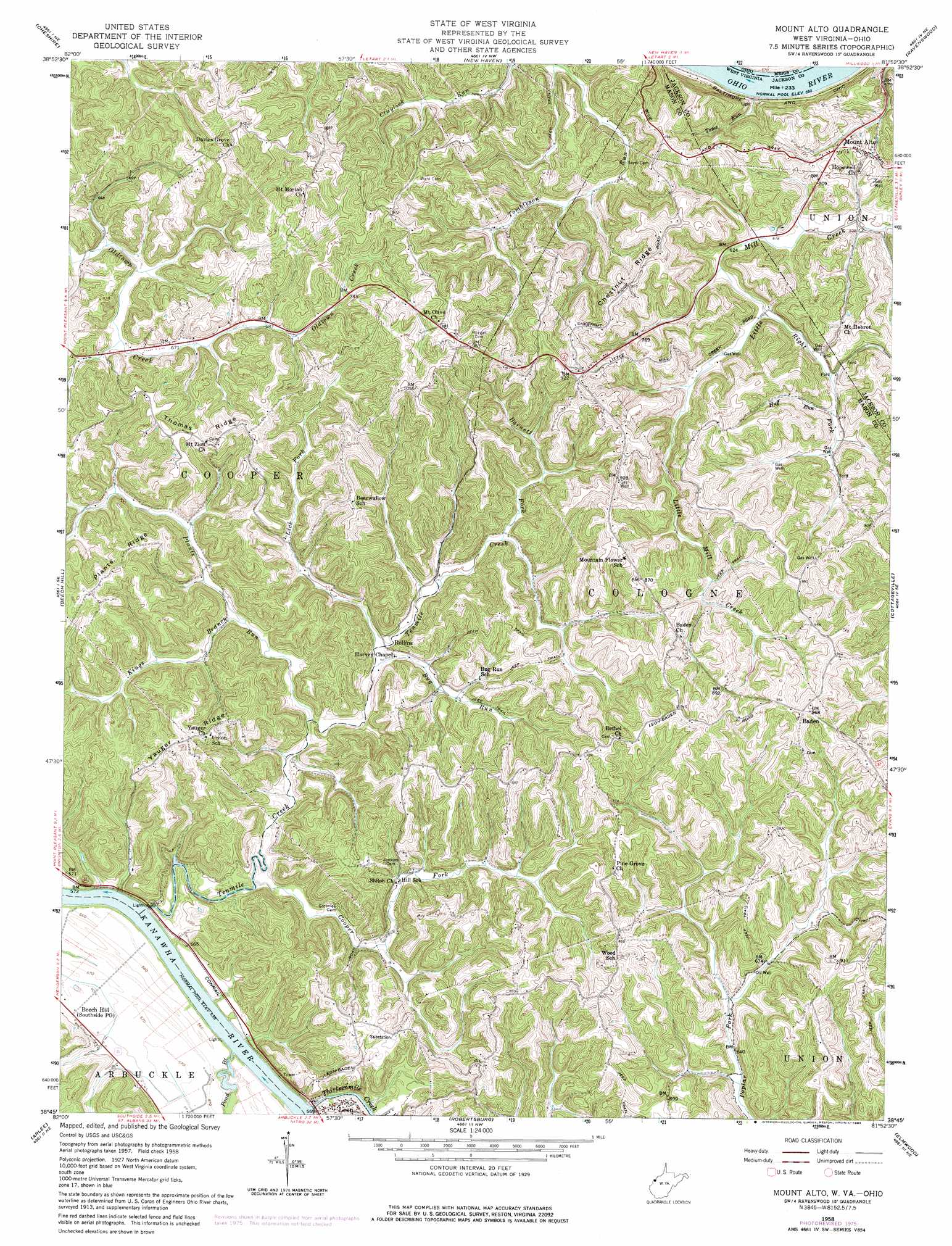
USGS Topo Quad 38081g8 - 1:24,000 scale
| Topo Map Name: | Mount Alto |
| USGS Topo Quad ID: | 38081g8 |
| Print Size: | ca. 21 1/4" wide x 27" high |
| Southeast Coordinates: | 38.75° N latitude / 81.875° W longitude |
| Map Center Coordinates: | 38.8125° N latitude / 81.9375° W longitude |
| U.S. States: | WV, OH |
| Filename: | o38081g8.jpg |
| Download Map JPG Image: | Mount Alto topo map 1:24,000 scale |
| Map Type: | Topographic |
| Topo Series: | 7.5´ |
| Map Scale: | 1:24,000 |
| Source of Map Images: | United States Geological Survey (USGS) |
| Alternate Map Versions: |
Mount Alto WV 1958, updated 1960 Download PDF Buy paper map Mount Alto WV 1958, updated 1969 Download PDF Buy paper map Mount Alto WV 1958, updated 1977 Download PDF Buy paper map Mount Alto WV 1958, updated 1984 Download PDF Buy paper map Mount Alto WV 1994, updated 1998 Download PDF Buy paper map Mount Alto WV 2011 Download PDF Buy paper map Mount Alto WV 2014 Download PDF Buy paper map Mount Alto WV 2016 Download PDF Buy paper map |
1:24,000 Topo Quads surrounding Mount Alto
Rutland |
Pomeroy |
Chester |
Portland |
Pond Creek |
Addison |
Cheshire |
New Haven |
Ravenswood |
Sandyville |
Gallipolis |
Beech Hill |
Mount Alto |
Cottageville |
Ripley |
Apple Grove |
Arlee |
Robertsburg |
Elmwood |
Kenna |
Glenwood |
Mount Olive |
Winfield |
Bancroft |
Sissonville |
> Back to 38081e1 at 1:100,000 scale
> Back to 38080a1 at 1:250,000 scale
> Back to U.S. Topo Maps home
Mount Alto topo map: Gazetteer
Mount Alto: Dams
Rollins Dam Number One elevation 250m 820′Rollins Lake Number Two Dam elevation 228m 748′
Mount Alto: Populated Places
Ash elevation 272m 892′Baden elevation 293m 961′
Chestnut elevation 294m 964′
Leon elevation 173m 567′
Mount Alto elevation 216m 708′
Rollins elevation 180m 590′
Wood elevation 267m 875′
Mount Alto: Post Offices
Mount Alto Post Office elevation 220m 721′Mount Alto: Ridges
Chestnut Ridge elevation 280m 918′Plants Ridge elevation 271m 889′
Thomas Ridge elevation 271m 889′
Yauger Ridge elevation 263m 862′
Mount Alto: Springs
Carl McDale Spring elevation 277m 908′Cleon Cadle Spring elevation 271m 889′
Clifford Vickers Spring elevation 205m 672′
Dowell Spring elevation 187m 613′
Everett Keefer Spring elevation 249m 816′
Gill Spring elevation 264m 866′
Guy Midturn Spring elevation 232m 761′
Harold Sayre Spring elevation 216m 708′
Homer Peck Spring elevation 229m 751′
Leo Roush Spring elevation 272m 892′
Leo Roush Spring elevation 270m 885′
Oscar Weigand Spring elevation 241m 790′
Oscar Weigand Spring elevation 260m 853′
Oscar Weigand Spring elevation 239m 784′
Otis Randolph Spring elevation 277m 908′
Rollins Spring elevation 245m 803′
Runion Spring elevation 253m 830′
Mount Alto: Streams
Barnett Fork elevation 190m 623′Bug Run elevation 172m 564′
Cooper Fork elevation 165m 541′
Huff Run elevation 203m 666′
Kings Branch elevation 173m 567′
Lick Fork elevation 172m 564′
Little Mill Creek elevation 190m 623′
Plants Run elevation 174m 570′
Pond Branch elevation 164m 538′
Tenmile Creek elevation 164m 538′
Thirteenmile Creek elevation 164m 538′
Toms Run elevation 169m 554′
Mount Alto digital topo map on disk
Buy this Mount Alto topo map showing relief, roads, GPS coordinates and other geographical features, as a high-resolution digital map file on DVD:
Western Virginia & Southern West Virginia
Buy digital topo maps: Western Virginia & Southern West Virginia