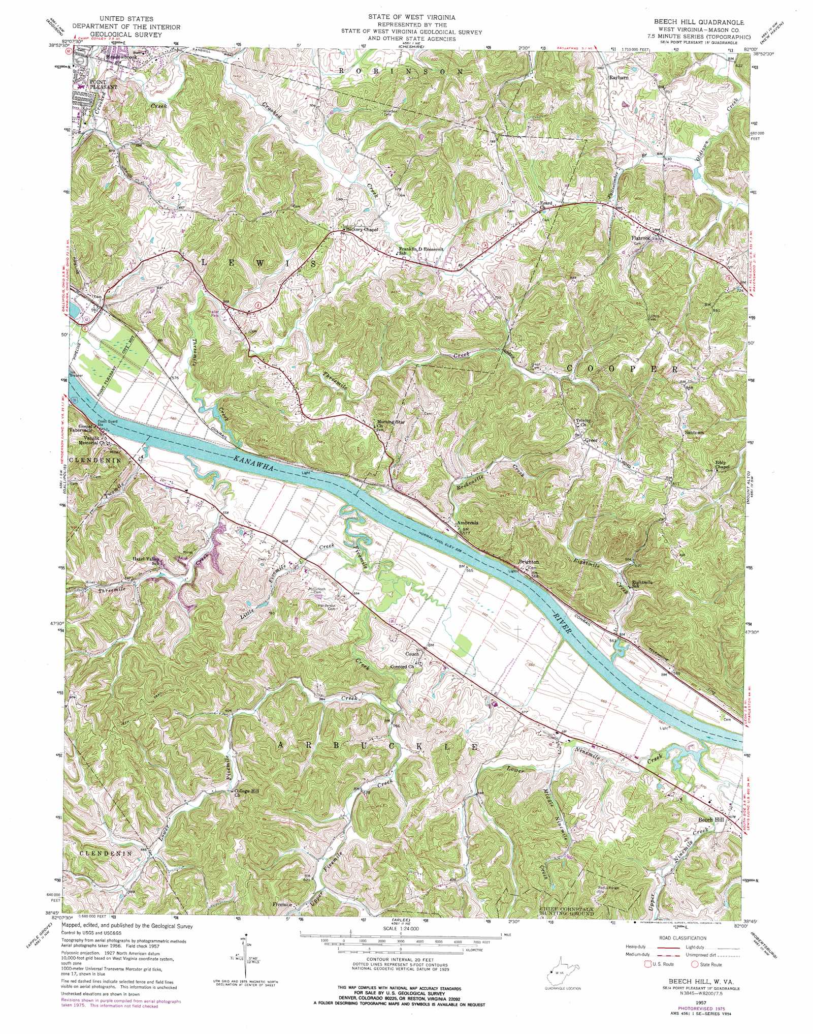
Beech Hill Topo Map West Virginia
To zoom in, hover over the map of Beech Hill
USGS Topo Quad 38082g1 - 1:24,000 scale
| Topo Map Name: | Beech Hill |
| USGS Topo Quad ID: | 38082g1 |
| Print Size: | ca. 21 1/4" wide x 27" high |
| Southeast Coordinates: | 38.75° N latitude / 82° W longitude |
| Map Center Coordinates: | 38.8125° N latitude / 82.0625° W longitude |
| U.S. State: | WV |
| Filename: | o38082g1.jpg |
| Download Map JPG Image: | Beech Hill topo map 1:24,000 scale |
| Map Type: | Topographic |
| Topo Series: | 7.5´ |
| Map Scale: | 1:24,000 |
| Source of Map Images: | United States Geological Survey (USGS) |
| Alternate Map Versions: |
Beech Hill WV 1957, updated 1959 Download PDF Buy paper map Beech Hill WV 1957, updated 1976 Download PDF Buy paper map Beech Hill WV 2011 Download PDF Buy paper map Beech Hill WV 2014 Download PDF Buy paper map Beech Hill WV 2016 Download PDF Buy paper map |
1:24,000 Topo Quads surrounding Beech Hill
Wilkesville |
Rutland |
Pomeroy |
Chester |
Portland |
Vinton |
Addison |
Cheshire |
New Haven |
Ravenswood |
Rodney |
Gallipolis |
Beech Hill |
Mount Alto |
Cottageville |
Mercerville |
Apple Grove |
Arlee |
Robertsburg |
Elmwood |
Athalia |
Glenwood |
Mount Olive |
Winfield |
Bancroft |
> Back to 38082e1 at 1:100,000 scale
> Back to 38082a1 at 1:250,000 scale
> Back to U.S. Topo Maps home
Beech Hill topo map: Gazetteer
Beech Hill: Airports
Pleasant Valley Hospital Heliport elevation 181m 593′Beech Hill: Dams
Lock Number 11 (historical) elevation 164m 538′Beech Hill: Populated Places
Ambrosia elevation 170m 557′Beech Hill elevation 174m 570′
Brighton elevation 171m 561′
Couch elevation 176m 577′
Fivemile elevation 191m 626′
Flatrock elevation 203m 666′
Greer elevation 220m 721′
Meadowbrook elevation 183m 600′
Rayburn elevation 201m 659′
Santown elevation 257m 843′
Stockton (historical) elevation 265m 869′
Wagner (historical) elevation 178m 583′
Beech Hill: Springs
Blain Spring elevation 201m 659′Clarence Casto Spring elevation 204m 669′
Dale Neibert Spring elevation 182m 597′
Dawley Spring elevation 185m 606′
Duff Spring elevation 249m 816′
Harold Edwards Spring elevation 189m 620′
Henderson Spring elevation 173m 567′
John Oshell Spring elevation 182m 597′
Keener Spring elevation 191m 626′
Leslie Rayburn Spring elevation 208m 682′
McCulloch Spring elevation 182m 597′
Ray Crank Spring elevation 180m 590′
Smith Spring elevation 246m 807′
Stanley Spring elevation 180m 590′
Stone Spring elevation 180m 590′
Williams Spring elevation 199m 652′
Williamson Spring elevation 183m 600′
Beech Hill: Streams
Arbuckle Creek elevation 165m 541′Eightmile Creek elevation 164m 538′
Fallentimber Branch elevation 187m 613′
Fivemile Creek elevation 164m 538′
Little Fivemile Creek elevation 164m 538′
Lower Fivemile Creek elevation 171m 561′
Lower Ninemile Creek elevation 172m 564′
Middle Ninemile Creek elevation 173m 567′
Rockcastle Creek elevation 164m 538′
Threemile Creek elevation 164m 538′
Threemile Creek elevation 164m 538′
Twomile Creek elevation 164m 538′
Upper Fivemile Creek elevation 170m 557′
Upper Ninemile Creek elevation 165m 541′
Beech Hill digital topo map on disk
Buy this Beech Hill topo map showing relief, roads, GPS coordinates and other geographical features, as a high-resolution digital map file on DVD:
Western Virginia & Southern West Virginia
Buy digital topo maps: Western Virginia & Southern West Virginia