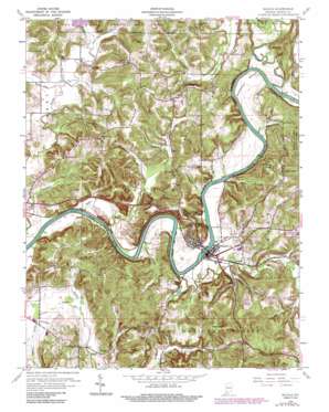
Shoals Topo Map Indiana
To zoom in, hover over the map of Shoals
USGS Topo Quad 38086f7 - 1:24,000 scale
| Topo Map Name: | Shoals |
| USGS Topo Quad ID: | 38086f7 |
| Print Size: | ca. 21 1/4" wide x 27" high |
| Southeast Coordinates: | 38.625° N latitude / 86.75° W longitude |
| Map Center Coordinates: | 38.6875° N latitude / 86.8125° W longitude |
| U.S. State: | IN |
| Filename: | o38086f7.jpg |
| Download Map JPG Image: | Shoals topo map 1:24,000 scale |
| Map Type: | Topographic |
| Topo Series: | 7.5´ |
| Map Scale: | 1:24,000 |
| Source of Map Images: | United States Geological Survey (USGS) |
| Alternate Map Versions: |
Shoals IN 1950 Download PDF Buy paper map Shoals IN 1960, updated 1960 Download PDF Buy paper map Shoals IN 1960, updated 1973 Download PDF Buy paper map Shoals IN 1960, updated 1990 Download PDF Buy paper map Shoals IN 1993, updated 1998 Download PDF Buy paper map Shoals IN 2010 Download PDF Buy paper map Shoals IN 2013 Download PDF Buy paper map Shoals IN 2017 Download PDF Buy paper map |
| FStopo: | US Forest Service topo Shoals is available: Download FStopo PDF Download FStopo TIF |
1:24,000 Topo Quads surrounding Shoals
> Back to 38086e1 at 1:100,000 scale
> Back to 38086a1 at 1:250,000 scale
> Back to U.S. Topo Maps home
Shoals topo map: Gazetteer
Shoals: Bends
Heathen Bend elevation 144m 472′Shoals: Cliffs
Cedar Bluff elevation 163m 534′McBrides Bluff elevation 150m 492′
Shoals: Forests
Martin County State Forest elevation 199m 652′Shoals: Gaps
Peek Cut elevation 222m 728′Shoals: Pillars
Pinnacle Rock elevation 195m 639′Shoals: Populated Places
Dover Hill elevation 202m 662′Ironton elevation 147m 482′
Lacy elevation 189m 620′
Pleasant Valley elevation 149m 488′
Shoals elevation 154m 505′
Shoals Overlook elevation 208m 682′
Shoals: Ridges
Hickory Ridge elevation 202m 662′Shoals: Springs
Chalybeate Springs elevation 160m 524′Spout Spring elevation 142m 465′
Shoals: Streams
American Run elevation 137m 449′Beaver Creek elevation 140m 459′
Beech Creek elevation 133m 436′
Branch Run elevation 150m 492′
Buck Knob Creek elevation 140m 459′
Buzzard Run elevation 134m 439′
Cedar Brook elevation 141m 462′
Church Brook elevation 142m 465′
Dover Run elevation 149m 488′
Flood Run elevation 137m 449′
Free Run elevation 142m 465′
Freemans Spring Branch elevation 137m 449′
French Run elevation 136m 446′
Grove Brook elevation 137m 449′
Gushing Creek elevation 141m 462′
Henry Creek elevation 136m 446′
Hickory Run elevation 139m 456′
Hill Branch elevation 192m 629′
Houghton Run elevation 143m 469′
House Rock Branch elevation 135m 442′
Indian Creek elevation 136m 446′
Indian Run elevation 140m 459′
Iron Creek elevation 139m 456′
Jet Run elevation 137m 449′
Knob Branch elevation 140m 459′
Lacy Drain elevation 157m 515′
Leaf Branch elevation 144m 472′
Lemon Run elevation 143m 469′
Limb Run elevation 154m 505′
Lime Run elevation 142m 465′
Mountain Stream elevation 137m 449′
Nest Brook elevation 143m 469′
Nubbin Ridge Branch elevation 133m 436′
Nut Brook elevation 140m 459′
Opossum Creek elevation 140m 459′
Overlook Drain elevation 136m 446′
Peek Run elevation 140m 459′
River Drain elevation 135m 442′
Root Brook elevation 146m 479′
Seed Tick Creek elevation 140m 459′
Sherfick Stream elevation 140m 459′
Sod Run elevation 140m 459′
Speel Creek elevation 134m 439′
Spurt Run elevation 136m 446′
Squirt Run elevation 138m 452′
Sum Creek elevation 146m 479′
Union Creek elevation 139m 456′
Windy Run elevation 143m 469′
Shoals: Summits
Buck Knob elevation 221m 725′House Rock elevation 190m 623′
Sampson Hill elevation 247m 810′
Shell Mound elevation 187m 613′
Shoals digital topo map on disk
Buy this Shoals topo map showing relief, roads, GPS coordinates and other geographical features, as a high-resolution digital map file on DVD:


