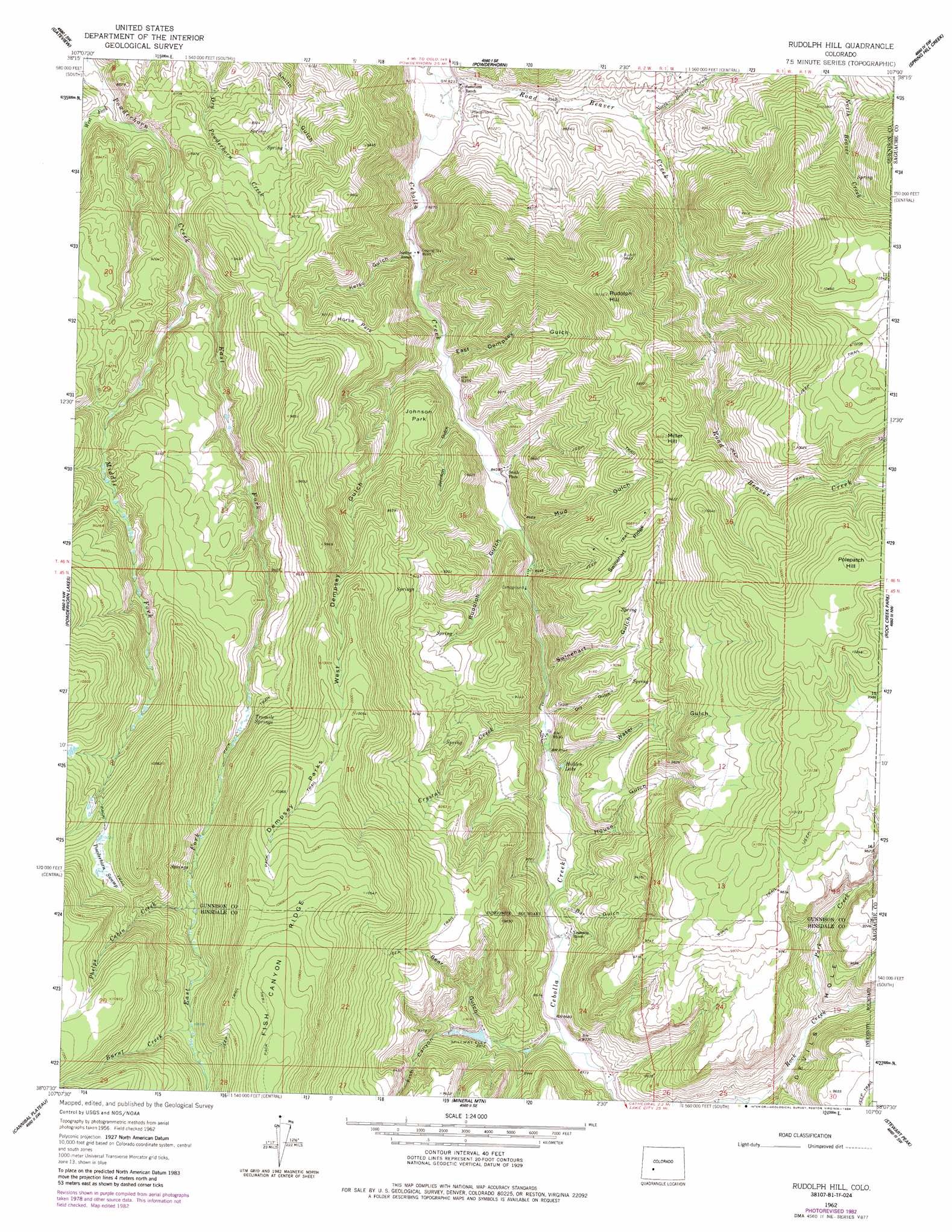
Rudolph Hill Topo Map Colorado
To zoom in, hover over the map of Rudolph Hill
USGS Topo Quad 38107b1 - 1:24,000 scale
| Topo Map Name: | Rudolph Hill |
| USGS Topo Quad ID: | 38107b1 |
| Print Size: | ca. 21 1/4" wide x 27" high |
| Southeast Coordinates: | 38.125° N latitude / 107° W longitude |
| Map Center Coordinates: | 38.1875° N latitude / 107.0625° W longitude |
| U.S. State: | CO |
| Filename: | o38107b1.jpg |
| Download Map JPG Image: | Rudolph Hill topo map 1:24,000 scale |
| Map Type: | Topographic |
| Topo Series: | 7.5´ |
| Map Scale: | 1:24,000 |
| Source of Map Images: | United States Geological Survey (USGS) |
| Alternate Map Versions: |
Rudolph Hill CO 1962, updated 1964 Download PDF Buy paper map Rudolph Hill CO 1962, updated 1972 Download PDF Buy paper map Rudolph Hill CO 1962, updated 1984 Download PDF Buy paper map Rudolph Hill CO 2011 Download PDF Buy paper map Rudolph Hill CO 2013 Download PDF Buy paper map Rudolph Hill CO 2016 Download PDF Buy paper map |
1:24,000 Topo Quads surrounding Rudolph Hill
Sapinero |
Carpenter Ridge |
Big Mesa |
Iris Nw |
Iris |
Poison Draw |
Gateview |
Powderhorn |
Spring Hill Creek |
Sawtooth Mountain |
Alpine Plateau |
Powderhorn Lakes |
Rudolph Hill |
Rock Creek Park |
Cold Spring Park |
Lake City |
Cannibal Plateau |
Mineral Mountain |
Stewart Peak |
Elk Park |
Lake San Cristobal |
Slumgullion Pass |
Baldy Cinco |
San Luis Peak |
Halfmoon Pass |
> Back to 38107a1 at 1:100,000 scale
> Back to 38106a1 at 1:250,000 scale
> Back to U.S. Topo Maps home
Rudolph Hill topo map: Gazetteer
Rudolph Hill: Dams
Bowers Lakes Dam elevation 2754m 9035′Rudolph Hill: Flats
Dempsey Parks elevation 3105m 10187′Horse Park elevation 2763m 9064′
Johnson Park elevation 2715m 8907′
Rudolph Hill: Mines
Alexite Mine elevation 2636m 8648′Vermiculite Mining Company Mine elevation 2676m 8779′
Rudolph Hill: Populated Places
Smith Place elevation 2572m 8438′Rudolph Hill: Reservoirs
Bowers Lakes elevation 2754m 9035′Hidden Lake elevation 2629m 8625′
Rudolph Hill: Ridges
Swinehart Ridge elevation 2955m 9694′Rudolph Hill: Springs
Tenmile Springs elevation 2873m 9425′Rudolph Hill: Streams
Burnt Creek elevation 3059m 10036′Crystal Creek elevation 2605m 8546′
East Fork Powderhorn Creek elevation 2668m 8753′
Middle Fork Powderhorn Creek elevation 2668m 8753′
North Beaver Creek elevation 2575m 8448′
Park Creek elevation 2734m 8969′
Phelps Cabin Creek elevation 2954m 9691′
Road Beaver Creek elevation 2502m 8208′
West Fork Powderhorn Creek elevation 2559m 8395′
Rudolph Hill: Summits
Miller Hill elevation 3003m 9852′Polepatch Hill elevation 3161m 10370′
Rudolph Hill elevation 3087m 10127′
Rudolph Hill: Valleys
Bar Gulch elevation 2640m 8661′Bear Gulch elevation 2718m 8917′
Burnt Draw elevation 2722m 8930′
Devils Hole elevation 2734m 8969′
Dry Gulch elevation 2613m 8572′
East Dempsey Gulch elevation 2548m 8359′
Fish Canyon elevation 2658m 8720′
House Gulch elevation 2622m 8602′
Johnson Gulch elevation 2551m 8369′
Kelso Gulch elevation 2535m 8316′
Mud Gulch elevation 2574m 8444′
Rudolph Gulch elevation 2573m 8441′
Swinehart Gulch elevation 2597m 8520′
Water Gulch elevation 2608m 8556′
West Dempsey Gulch elevation 2548m 8359′
Rudolph Hill digital topo map on disk
Buy this Rudolph Hill topo map showing relief, roads, GPS coordinates and other geographical features, as a high-resolution digital map file on DVD: