Cold Spring Park Topo Map Colorado
To zoom in, hover over the map of Cold Spring Park
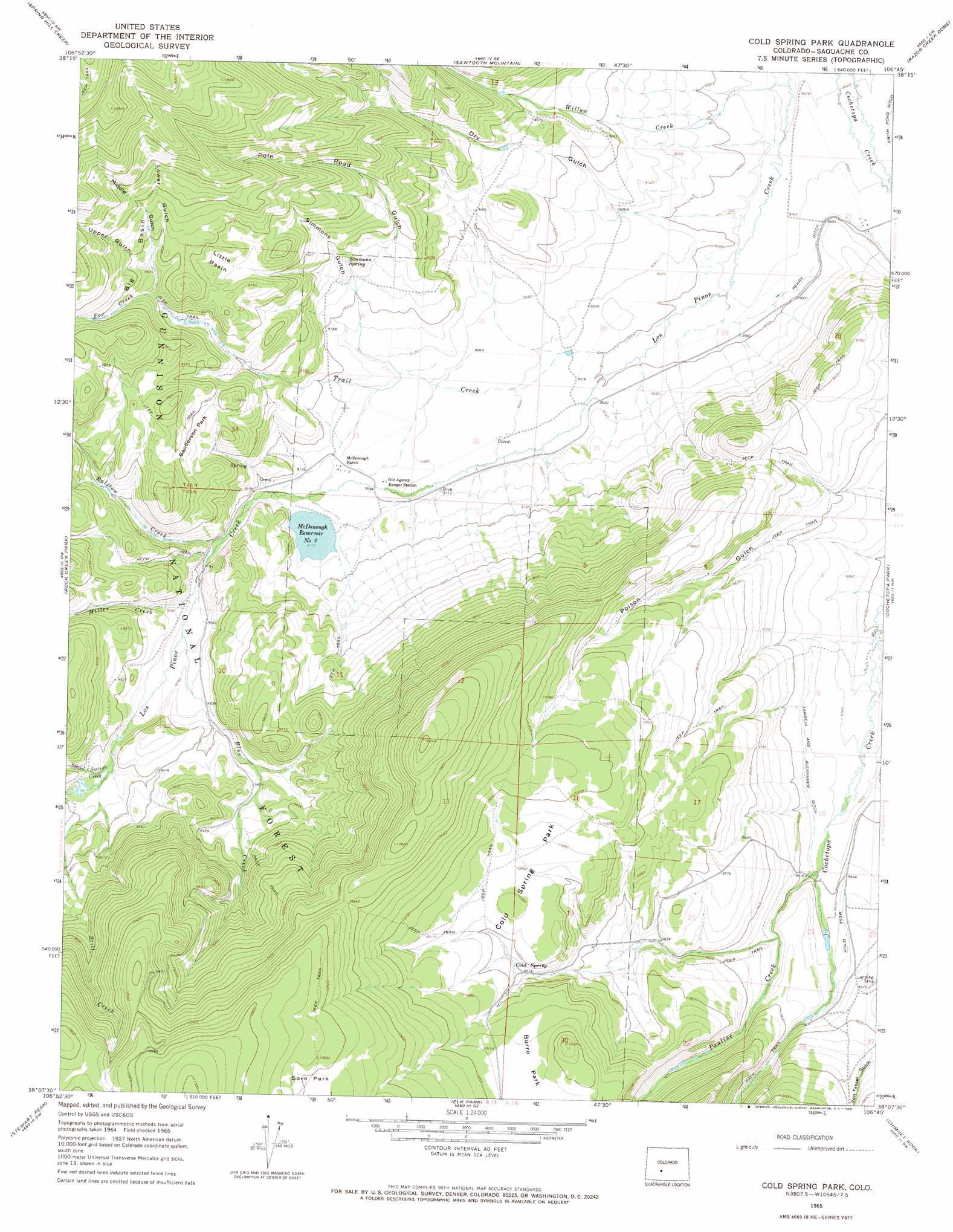
USGS Topo Quad 38106b7 - 1:24,000 scale
| Topo Map Name: | Cold Spring Park |
| USGS Topo Quad ID: | 38106b7 |
| Print Size: | ca. 21 1/4" wide x 27" high |
| Southeast Coordinates: | 38.125° N latitude / 106.75° W longitude |
| Map Center Coordinates: | 38.1875° N latitude / 106.8125° W longitude |
| U.S. State: | CO |
| Filename: | o38106b7.jpg |
| Download Map JPG Image: | Cold Spring Park topo map 1:24,000 scale |
| Map Type: | Topographic |
| Topo Series: | 7.5´ |
| Map Scale: | 1:24,000 |
| Source of Map Images: | United States Geological Survey (USGS) |
| Alternate Map Versions: |
Cold Spring Park CO 1965, updated 1968 Download PDF Buy paper map Cold Spring Park CO 1965, updated 1968 Download PDF Buy paper map Cold Spring Park CO 2001, updated 2004 Download PDF Buy paper map Cold Spring Park CO 2011 Download PDF Buy paper map Cold Spring Park CO 2013 Download PDF Buy paper map Cold Spring Park CO 2016 Download PDF Buy paper map |
| FStopo: | US Forest Service topo Cold Spring Park is available: Download FStopo PDF Download FStopo TIF |
1:24,000 Topo Quads surrounding Cold Spring Park
Big Mesa |
Iris Nw |
Iris |
Houston Gulch |
Doyleville |
Powderhorn |
Spring Hill Creek |
Sawtooth Mountain |
Razor Creek Dome |
West Baldy |
Rudolph Hill |
Rock Creek Park |
Cold Spring Park |
Cochetopa Park |
North Pass |
Mineral Mountain |
Stewart Peak |
Elk Park |
Saguache Park |
Grouse Creek |
Baldy Cinco |
San Luis Peak |
Halfmoon Pass |
Mesa Mountain |
Bowers Peak |
> Back to 38106a1 at 1:100,000 scale
> Back to 38106a1 at 1:250,000 scale
> Back to U.S. Topo Maps home
Cold Spring Park topo map: Gazetteer
Cold Spring Park: Basins
Big Basin elevation 2982m 9783′Little Basin elevation 2965m 9727′
Cold Spring Park: Canals
Smith Ford Ditch elevation 2727m 8946′Tarbell and Alexander Ditch elevation 2854m 9363′
Cold Spring Park: Dams
McDonough Number 1 Dam elevation 2870m 9416′McDonough Number 2 Dam elevation 2792m 9160′
Cold Spring Park: Flats
Cold Spring Park elevation 3063m 10049′Sanderson Park elevation 2918m 9573′
Cold Spring Park: Reservoirs
McDonough Reservoir Number 1 elevation 2870m 9416′McDonough Reservoir Number 2 elevation 2792m 9160′
Cold Spring Park: Springs
Cold Spring elevation 3032m 9947′Simmons Spring elevation 2840m 9317′
Cold Spring Park: Streams
Blue Creek elevation 2822m 9258′Fox Creek elevation 2932m 9619′
Miller Creek elevation 2806m 9206′
Pauline Creek elevation 2854m 9363′
Ralston Creek elevation 2802m 9192′
School Section Creek elevation 2837m 9307′
Trail Creek elevation 2739m 8986′
Willow Creek elevation 2719m 8920′
Cold Spring Park: Valleys
Dry Gulch elevation 2731m 8959′Lower Gulch elevation 2971m 9747′
Middle Gulch elevation 2954m 9691′
Poison Gulch elevation 2801m 9189′
Pole Road Gulch elevation 2852m 9356′
Simmons Gulch elevation 2817m 9242′
Upper Gulch elevation 2959m 9708′
Cold Spring Park digital topo map on disk
Buy this Cold Spring Park topo map showing relief, roads, GPS coordinates and other geographical features, as a high-resolution digital map file on DVD: