Johns Peak Topo Map Utah
To zoom in, hover over the map of Johns Peak
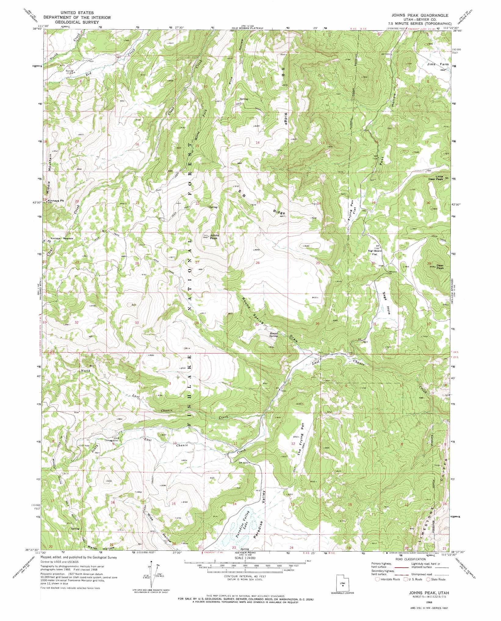
USGS Topo Quad 38111f4 - 1:24,000 scale
| Topo Map Name: | Johns Peak |
| USGS Topo Quad ID: | 38111f4 |
| Print Size: | ca. 21 1/4" wide x 27" high |
| Southeast Coordinates: | 38.625° N latitude / 111.375° W longitude |
| Map Center Coordinates: | 38.6875° N latitude / 111.4375° W longitude |
| U.S. State: | UT |
| Filename: | o38111f4.jpg |
| Download Map JPG Image: | Johns Peak topo map 1:24,000 scale |
| Map Type: | Topographic |
| Topo Series: | 7.5´ |
| Map Scale: | 1:24,000 |
| Source of Map Images: | United States Geological Survey (USGS) |
| Alternate Map Versions: |
Johns Peak UT 1968, updated 1972 Download PDF Buy paper map Johns Peak UT 2001, updated 2003 Download PDF Buy paper map Johns Peak UT 2011 Download PDF Buy paper map Johns Peak UT 2014 Download PDF Buy paper map |
| FStopo: | US Forest Service topo Johns Peak is available: Download FStopo PDF Download FStopo TIF |
1:24,000 Topo Quads surrounding Johns Peak
Steves Mountain |
Water Hollow Ridge |
Acord Lakes |
Emery West |
Emery East |
Gooseberry Creek |
Yogo Creek |
Old Woman Plateau |
Walker Flat |
Mesa Butte |
Mount Terrill |
Hilgard Mountain |
Johns Peak |
Willow Springs |
Mussentuchit Flat |
Fish Lake |
Forsyth Reservoir |
Geyser Peak |
Solomons Temple |
Salvation Creek |
Loa |
Lyman |
Flat Top |
Cathedral Mountain |
Fruita Nw |
> Back to 38111e1 at 1:100,000 scale
> Back to 38110a1 at 1:250,000 scale
> Back to U.S. Topo Maps home
Johns Peak topo map: Gazetteer
Johns Peak: Basins
Paradise Valley elevation 2414m 7919′Sage Hole elevation 2280m 7480′
Johns Peak: Flats
Frying Pan Flat elevation 2302m 7552′Jims Farm elevation 2121m 6958′
Kinneys Meadow elevation 2643m 8671′
Poverty Flat elevation 2586m 8484′
Sign Board Flat elevation 2352m 7716′
The Frying Pan elevation 2459m 8067′
Johns Peak: Lakes
Paradise Valley Lake elevation 2414m 7919′Johns Peak: Populated Places
Whipup elevation 2351m 7713′Johns Peak: Ridges
S B Ridge elevation 2650m 8694′Johns Peak: Springs
Round Spring elevation 2356m 7729′Johns Peak: Streams
Horse Fork elevation 2331m 7647′North Fork Clear Creek elevation 2647m 8684′
North Last Chance Creek elevation 2367m 7765′
South Last Chance Creek elevation 2366m 7762′
Johns Peak: Summits
Alice Mount elevation 2543m 8343′Deer Peak elevation 2564m 8412′
Johns Peak elevation 2907m 9537′
Kinneys Peak elevation 2876m 9435′
Little Deer Peak elevation 2394m 7854′
Middle Mountain elevation 2879m 9445′
Johns Peak: Valleys
Round Spring Draw elevation 2291m 7516′Johns Peak digital topo map on disk
Buy this Johns Peak topo map showing relief, roads, GPS coordinates and other geographical features, as a high-resolution digital map file on DVD: