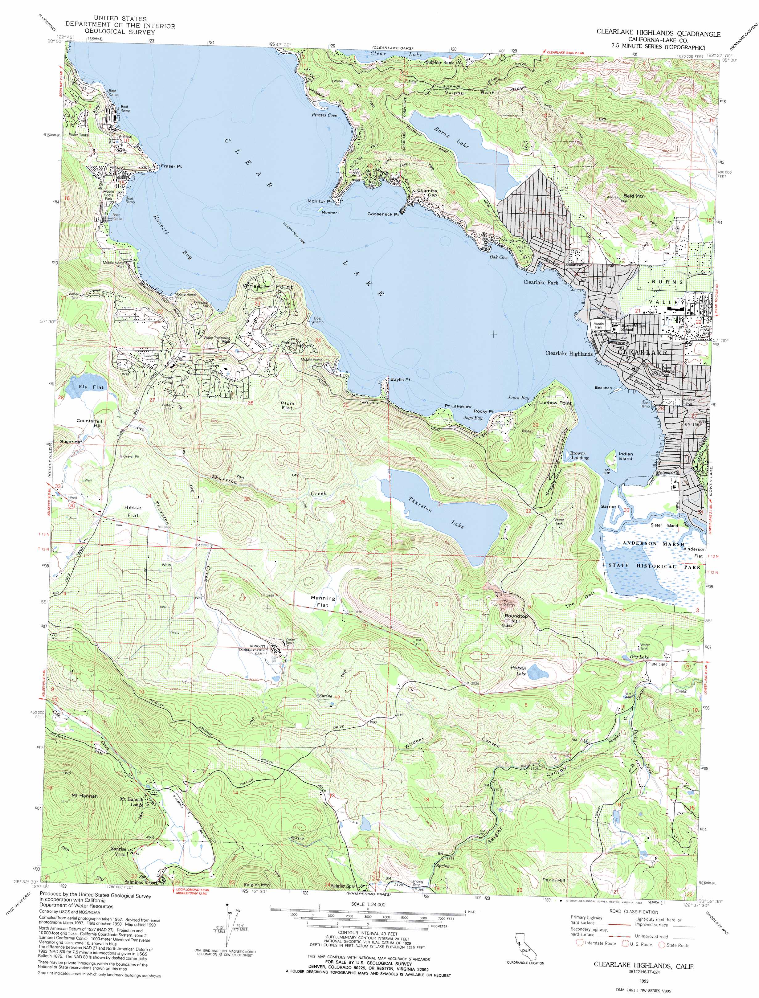
Clearlake Topo Map California
To zoom in, hover over the map of Clearlake
USGS Topo Quad 38122h6 - 1:24,000 scale
| Topo Map Name: | Clearlake |
| USGS Topo Quad ID: | 38122h6 |
| Print Size: | ca. 21 1/4" wide x 27" high |
| Southeast Coordinates: | 38.875° N latitude / 122.625° W longitude |
| Map Center Coordinates: | 38.9375° N latitude / 122.6875° W longitude |
| U.S. State: | CA |
| Filename: | o38122h6.jpg |
| Download Map JPG Image: | Clearlake topo map 1:24,000 scale |
| Map Type: | Topographic |
| Topo Series: | 7.5´ |
| Map Scale: | 1:24,000 |
| Source of Map Images: | United States Geological Survey (USGS) |
| Alternate Map Versions: |
Clearlake Highlands CA 1958, updated 1961 Download PDF Buy paper map Clearlake Highlands CA 1958, updated 1968 Download PDF Buy paper map Clearlake Highlands CA 1958, updated 1968 Download PDF Buy paper map Clearlake Highlands CA 1958, updated 1978 Download PDF Buy paper map Clearlake Highlands CA 1958, updated 1978 Download PDF Buy paper map Clearlake Highlands CA 1977, updated 1980 Download PDF Buy paper map Clearlake Highlands CA 1993, updated 1993 Download PDF Buy paper map Clearlake Highlands CA 2012 Download PDF Buy paper map Clearlake Highlands CA 2015 Download PDF Buy paper map |
1:24,000 Topo Quads surrounding Clearlake
Upper Lake |
Bartlett Mountain |
Bartlett Springs |
Hough Springs |
Leesville |
Lakeport |
Lucerne |
Clearlake Oaks |
Benmore Canyon |
Wilbur Springs |
Highland Springs |
Kelseyville |
Clearlake |
Lower Lake |
Wilson Valley |
Asti |
The Geysers |
Whispering Pines |
Middletown |
Jericho Valley |
Geyserville |
Jimtown |
Mount Saint Helena |
Detert Reservoir |
Aetna Springs |
> Back to 38122e1 at 1:100,000 scale
> Back to 38122a1 at 1:250,000 scale
> Back to U.S. Topo Maps home
Clearlake topo map: Gazetteer
Clearlake: Airports
Konocti-Clear Lake Seaplane Base elevation 406m 1332′Clearlake: Bays
Jago Bay elevation 406m 1332′Jones Bay elevation 410m 1345′
Konocti Bay elevation 406m 1332′
Lily Cove elevation 405m 1328′
North Cove elevation 405m 1328′
Oak Cove elevation 406m 1332′
Pirates Cove elevation 406m 1332′
Clearlake: Capes
Baylis Point elevation 406m 1332′Fraser Point elevation 420m 1377′
Gooseneck Point elevation 406m 1332′
Luebow Point elevation 458m 1502′
Monitor Point elevation 406m 1332′
Peacock Point elevation 414m 1358′
Point Lakeview elevation 414m 1358′
Ridge Point elevation 411m 1348′
Rocky Point elevation 416m 1364′
Wheeler Point elevation 439m 1440′
Clearlake: Flats
Ely Flat elevation 546m 1791′Hesse Flat elevation 571m 1873′
Manning Flat elevation 567m 1860′
Plum Flat elevation 562m 1843′
Clearlake: Gaps
Chamisa Gap elevation 420m 1377′Clearlake: Islands
Beakban Island elevation 409m 1341′Garner Island elevation 414m 1358′
Indian Island elevation 415m 1361′
Monitor Island elevation 406m 1332′
Slater Island elevation 412m 1351′
Clearlake: Lakes
Borax Lake elevation 411m 1348′Dry Lake elevation 464m 1522′
Pinkeye Lake elevation 518m 1699′
Thurston Lake elevation 431m 1414′
Clearlake: Parks
Anderson Marsh State Historic Park elevation 411m 1348′Austin Park elevation 410m 1345′
McVicar Wildlife Sanctuary elevation 424m 1391′
Redbud Park elevation 414m 1358′
Clearlake: Populated Places
Clear Lake Riviera elevation 535m 1755′Clearlake elevation 432m 1417′
Clearlake Highlands elevation 411m 1348′
Clearlake Park elevation 415m 1361′
Mount Hannah Lodge elevation 791m 2595′
Riviera Estates elevation 454m 1489′
Riviera West elevation 516m 1692′
Salminas Resort elevation 793m 2601′
Sunrise Vista elevation 793m 2601′
Clearlake: Post Offices
Clearlake Park Post Office elevation 409m 1341′Clearlake Post Office elevation 413m 1354′
Clearlake: Ridges
Sulphur Bank Ridge elevation 581m 1906′Clearlake: Streams
Burns Valley elevation 410m 1345′Molesworth Creek elevation 410m 1345′
Perini Creek elevation 445m 1459′
Thurston Creek elevation 437m 1433′
Clearlake: Summits
Bald Mountain elevation 660m 2165′Counterfeit Hill elevation 575m 1886′
Mount Hannah elevation 1213m 3979′
Perini Hill elevation 770m 2526′
Roundtop Mountain elevation 692m 2270′
Clearlake: Swamps
Anderson Marsh elevation 408m 1338′Clearlake: Trails
Marsh Trail elevation 415m 1361′Ridge Trail elevation 418m 1371′
Clearlake: Valleys
Grigsby Draw elevation 412m 1351′Seigler Canyon elevation 437m 1433′
Seigler Valley elevation 624m 2047′
The Dell elevation 414m 1358′
Wildcat Canyon elevation 496m 1627′
Clearlake digital topo map on disk
Buy this Clearlake topo map showing relief, roads, GPS coordinates and other geographical features, as a high-resolution digital map file on DVD: