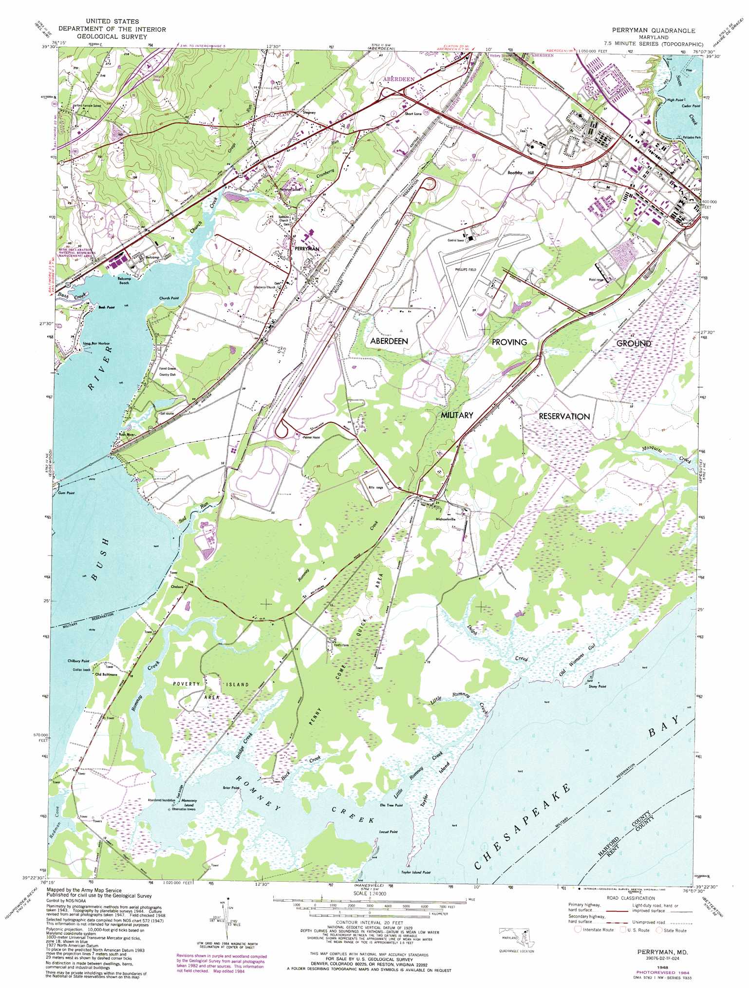
Perryman Topo Map Maryland
To zoom in, hover over the map of Perryman
USGS Topo Quad 39076d2 - 1:24,000 scale
| Topo Map Name: | Perryman |
| USGS Topo Quad ID: | 39076d2 |
| Print Size: | ca. 21 1/4" wide x 27" high |
| Southeast Coordinates: | 39.375° N latitude / 76.125° W longitude |
| Map Center Coordinates: | 39.4375° N latitude / 76.1875° W longitude |
| U.S. State: | MD |
| Filename: | o39076d2.jpg |
| Download Map JPG Image: | Perryman topo map 1:24,000 scale |
| Map Type: | Topographic |
| Topo Series: | 7.5´ |
| Map Scale: | 1:24,000 |
| Source of Map Images: | United States Geological Survey (USGS) |
| Alternate Map Versions: |
Perryman MD 1948 Download PDF Buy paper map Perryman MD 1948, updated 1972 Download PDF Buy paper map Perryman MD 1948, updated 1976 Download PDF Buy paper map Perryman MD 1948, updated 1985 Download PDF Buy paper map Perryman MD 1948, updated 1990 Download PDF Buy paper map Perryman MD 1949 Download PDF Buy paper map Perryman MD 1968 Download PDF Buy paper map Perryman MD 2014 Download PDF Buy paper map Perryman MD 2016 Download PDF Buy paper map |
1:24,000 Topo Quads surrounding Perryman
Fawn Grove |
Delta |
Conowingo Dam |
Rising Sun |
Bay View |
Jarrettsville |
Bel Air |
Aberdeen |
Havre De Grace |
North East |
White Marsh |
Edgewood |
Perryman |
Spesutie |
Earleville |
Middle River |
Gunpowder Neck |
Hanesville |
Betterton |
Galena |
Sparrows Point |
Swan Point |
Rock Hall |
Chestertown |
Church Hill |
> Back to 39076a1 at 1:100,000 scale
> Back to 39076a1 at 1:250,000 scale
> Back to U.S. Topo Maps home
Perryman topo map: Gazetteer
Perryman: Airports
Aberdeen Airpark (historical) elevation 19m 62′Perryman: Areas
Penny Come Quick Area elevation 6m 19′Poverty Island Area elevation 3m 9′
Perryman: Bars
Sewells Bar elevation 0m 0′Perryman: Beaches
Belcamp Beach elevation 3m 9′Perryman: Capes
Briar Point elevation 0m 0′Bush Point elevation 0m 0′
Chilbury Point elevation 1m 3′
Church Point elevation 1m 3′
Elm Tree Point elevation 0m 0′
Gum Point elevation 2m 6′
High Point elevation 1m 3′
Locust Point elevation 0m 0′
Stony Point elevation 1m 3′
Swan Neck elevation 6m 19′
Taylor Island Point elevation 0m 0′
Perryman: Harbors
Long Bar Harbor elevation -2m -7′Perryman: Islands
Monocacy Island elevation 1m 3′Taylor Island elevation 3m 9′
Perryman: Parks
Palisades Park elevation 0m 0′Perryman Park elevation 9m 29′
Shine Field elevation 18m 59′
Perryman: Populated Places
Bayside Village elevation 18m 59′Belcamp elevation 7m 22′
Bush River elevation 0m 0′
Bush River Mobile Home Park elevation 6m 19′
Chelsea elevation 3m 9′
Cole (historical) elevation 7m 22′
Forest Greens elevation 7m 22′
Henley Park elevation 40m 131′
Michaelsville elevation 6m 19′
Old Baltimore elevation 4m 13′
Perryman elevation 12m 39′
Perrywood elevation 6m 19′
Ripkins Corner elevation 7m 22′
Riverside elevation 24m 78′
Riverside Village of Church Creek elevation 19m 62′
Wildwood elevation 6m 19′
Wrights Mobile Home Village elevation 14m 45′
Wrights Trailer Village elevation 12m 39′
Perryman: Post Offices
Aberdeen Proving Ground Post Office elevation 13m 42′Belcamp Post Office elevation 6m 19′
Perryman Post Office elevation 13m 42′
Perryman: Streams
Back Creek elevation 0m 0′Bridge Creek elevation 0m 0′
Bush Creek elevation 0m 0′
Church Creek elevation 0m 0′
Cranberry Run elevation 0m 0′
Deep Spring Branch elevation 0m 0′
Delph Creek elevation -3m -10′
Grays Run elevation 5m 16′
Little Romney Creek elevation 0m 0′
Little Romney Creek elevation 0m 0′
Old Womans Gut elevation 1m 3′
Otter Point Creek elevation 0m 0′
Romney Creek elevation 0m 0′
Sod Run elevation 0m 0′
Perryman: Summits
Boothby Hill elevation 19m 62′Perryman digital topo map on disk
Buy this Perryman topo map showing relief, roads, GPS coordinates and other geographical features, as a high-resolution digital map file on DVD:
Atlantic Coast (NY, NJ, PA, DE, MD, VA, NC)
Buy digital topo maps: Atlantic Coast (NY, NJ, PA, DE, MD, VA, NC)
 map DVD")