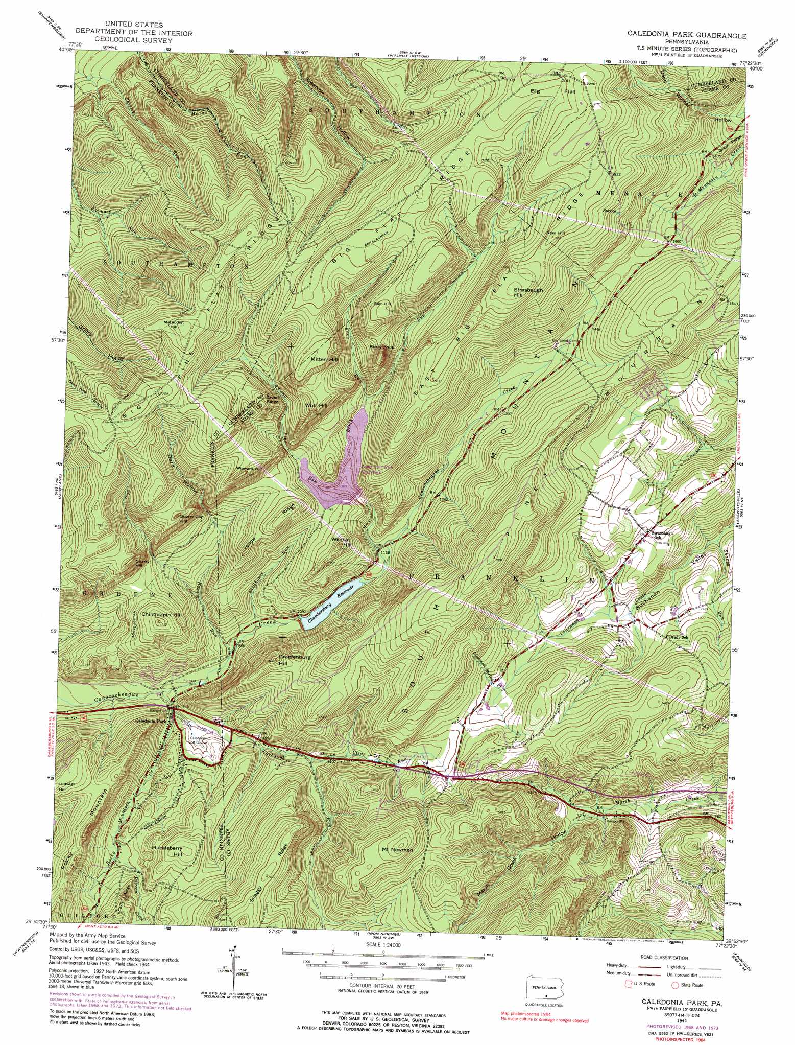
Caledonia Park Topo Map Pennsylvania
To zoom in, hover over the map of Caledonia Park
USGS Topo Quad 39077h4 - 1:24,000 scale
| Topo Map Name: | Caledonia Park |
| USGS Topo Quad ID: | 39077h4 |
| Print Size: | ca. 21 1/4" wide x 27" high |
| Southeast Coordinates: | 39.875° N latitude / 77.375° W longitude |
| Map Center Coordinates: | 39.9375° N latitude / 77.4375° W longitude |
| U.S. State: | PA |
| Filename: | o39077h4.jpg |
| Download Map JPG Image: | Caledonia Park topo map 1:24,000 scale |
| Map Type: | Topographic |
| Topo Series: | 7.5´ |
| Map Scale: | 1:24,000 |
| Source of Map Images: | United States Geological Survey (USGS) |
| Alternate Map Versions: |
Caledonia Park PA 1944, updated 1960 Download PDF Buy paper map Caledonia Park PA 1944, updated 1964 Download PDF Buy paper map Caledonia Park PA 1944, updated 1969 Download PDF Buy paper map Caledonia Park PA 1944, updated 1974 Download PDF Buy paper map Caledonia Park PA 1944, updated 1988 Download PDF Buy paper map Caledonia Park PA 1990, updated 1995 Download PDF Buy paper map Caledonia Park PA 2010 Download PDF Buy paper map Caledonia Park PA 2013 Download PDF Buy paper map Caledonia Park PA 2016 Download PDF Buy paper map |
1:24,000 Topo Quads surrounding Caledonia Park
Doylesburg |
Newburg |
Newville |
Plainfield |
Carlisle |
Roxbury |
Shippensburg |
Walnut Bottom |
Dickinson |
Mount Holly Springs |
Chambersburg |
Scotland |
Caledonia Park |
Arendtsville |
Biglerville |
Greencastle |
Waynesboro |
Iron Springs |
Fairfield |
Gettysburg |
Hagerstown |
Smithsburg |
Blue Ridge Summit |
Emmitsburg |
Taneytown |
> Back to 39077e1 at 1:100,000 scale
> Back to 39076a1 at 1:250,000 scale
> Back to U.S. Topo Maps home
Caledonia Park topo map: Gazetteer
Caledonia Park: Airports
Big Flat Heliport elevation 625m 2050′Caledonia Park: Areas
Carbaugh Run Natural Area elevation 416m 1364′Caledonia Park: Dams
Birch Run Reservoir Dam elevation 318m 1043′Caledonia Water Company Dam elevation 357m 1171′
Furnace Dam elevation 291m 954′
Long Pine Run Dam elevation 419m 1374′
Caledonia Park: Flats
Big Flat elevation 616m 2020′Caledonia Park: Parks
Caledonia State Park elevation 334m 1095′Caledonia Park: Populated Places
Caledonia Park elevation 289m 948′Graefenburg elevation 312m 1023′
Trust elevation 360m 1181′
Caledonia Park: Post Offices
Graefenburg Post Office elevation 317m 1040′Caledonia Park: Ranges
South Mountain elevation 479m 1571′Caledonia Park: Reservoirs
Caledonia Water Company Pond elevation 357m 1171′Chambersburg Reservoir elevation 318m 1043′
Long Pine Run Reservoir elevation 415m 1361′
Caledonia Park: Ridges
Big Flat Ridge elevation 586m 1922′Big Pine Flat Ridge elevation 621m 2037′
East Big Flat Ridge elevation 580m 1902′
Green Ridge elevation 556m 1824′
Snaggy Ridge elevation 501m 1643′
Yellow Ridge elevation 468m 1535′
Caledonia Park: Streams
Birch Run elevation 417m 1368′Carbaugh Run elevation 286m 938′
Clear Run elevation 328m 1076′
Hosack Run elevation 299m 980′
Knob Run elevation 418m 1371′
Lippencot Spring Creek elevation 377m 1236′
Long Pine Run elevation 340m 1115′
McDowells Run elevation 388m 1272′
Raccoon Creek elevation 328m 1076′
Rocky Mountain Creek elevation 283m 928′
Sharps Run elevation 314m 1030′
Stillhouse Run elevation 306m 1003′
Caledonia Park: Summits
Chinquapin Hill elevation 463m 1519′Graefenburg Hill elevation 464m 1522′
Huckleberry Hill elevation 422m 1384′
Ludwigs Hill elevation 454m 1489′
Methodist Hill elevation 631m 2070′
Mitten Hill elevation 587m 1925′
Mount Newman elevation 544m 1784′
Orebank Hill elevation 342m 1122′
Piney Mountain elevation 513m 1683′
Quarry Gap Hill elevation 523m 1715′
Quarry Hill elevation 523m 1715′
Ram Hill elevation 595m 1952′
Rocky Knob elevation 566m 1856′
Sier Hill elevation 586m 1922′
Strasbaugh Hill elevation 605m 1984′
Wigwam Hill elevation 549m 1801′
Wildcat Hill elevation 465m 1525′
Wolf Hill elevation 551m 1807′
Caledonia Park: Trails
Lippencot Trail elevation 541m 1774′Wildcat Trail elevation 569m 1866′
Caledonia Park: Valleys
Dark Hollow elevation 397m 1302′Marsh Creek Hollow elevation 318m 1043′
Caledonia Park digital topo map on disk
Buy this Caledonia Park topo map showing relief, roads, GPS coordinates and other geographical features, as a high-resolution digital map file on DVD:
Atlantic Coast (NY, NJ, PA, DE, MD, VA, NC)
Buy digital topo maps: Atlantic Coast (NY, NJ, PA, DE, MD, VA, NC)
 map DVD")