Oakland Topo Map Maryland
To zoom in, hover over the map of Oakland
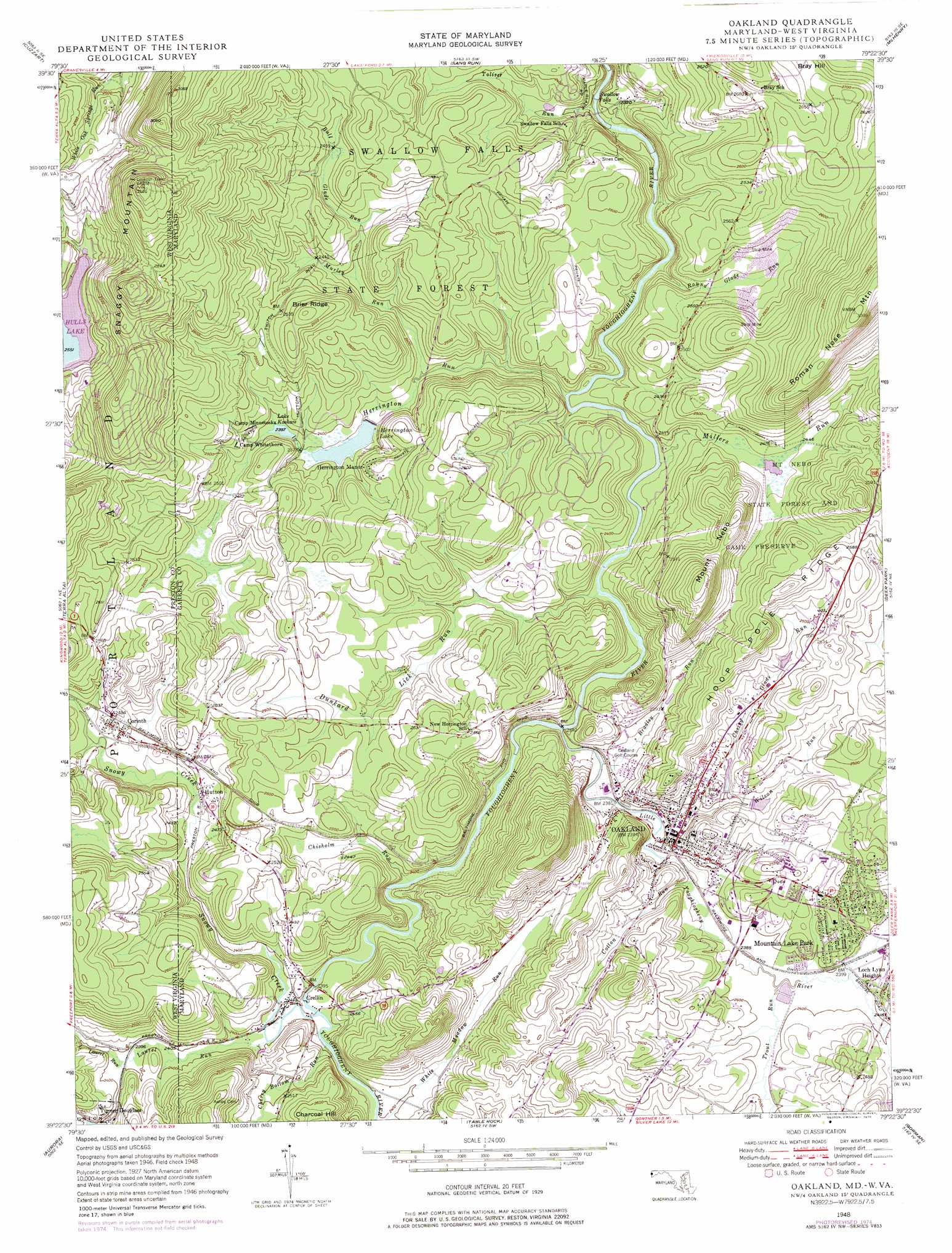
USGS Topo Quad 39079d4 - 1:24,000 scale
| Topo Map Name: | Oakland |
| USGS Topo Quad ID: | 39079d4 |
| Print Size: | ca. 21 1/4" wide x 27" high |
| Southeast Coordinates: | 39.375° N latitude / 79.375° W longitude |
| Map Center Coordinates: | 39.4375° N latitude / 79.4375° W longitude |
| U.S. States: | MD, WV |
| Filename: | o39079d4.jpg |
| Download Map JPG Image: | Oakland topo map 1:24,000 scale |
| Map Type: | Topographic |
| Topo Series: | 7.5´ |
| Map Scale: | 1:24,000 |
| Source of Map Images: | United States Geological Survey (USGS) |
| Alternate Map Versions: |
Oakland MD 1948, updated 1958 Download PDF Buy paper map Oakland MD 1948, updated 1967 Download PDF Buy paper map Oakland MD 1948, updated 1975 Download PDF Buy paper map Oakland MD 1950 Download PDF Buy paper map Oakland MD 1950, updated 1950 Download PDF Buy paper map Oakland MD 1997, updated 2002 Download PDF Buy paper map Oakland MD 2011 Download PDF Buy paper map Oakland MD 2014 Download PDF Buy paper map Oakland MD 2016 Download PDF Buy paper map |
1:24,000 Topo Quads surrounding Oakland
Bruceton Mills |
Brandonville |
Friendsville |
Accident |
Grantsville |
Valley Point |
Cuzzart |
Sang Run |
Mchenry |
Bittinger |
Kingwood |
Terra Alta |
Oakland |
Deer Park |
Kitzmiller |
Rowlesburg |
Aurora |
Table Rock |
Gorman |
Mount Storm |
Saint George |
Lead Mine |
Davis |
Mount Storm Lake |
Greenland Gap |
> Back to 39079a1 at 1:100,000 scale
> Back to 39078a1 at 1:250,000 scale
> Back to U.S. Topo Maps home
Oakland topo map: Gazetteer
Oakland: Airports
Garrett County Memorial Hospital Heliport elevation 747m 2450′Oakland: Dams
Appalachian Lake Dam elevation 734m 2408′Herrington Creek Dam elevation 735m 2411′
Little Youghiogheny River Site Number 2 Dam elevation 763m 2503′
Little Youghiogheny Site Number 1 Dam elevation 738m 2421′
McComas Dam elevation 730m 2395′
Oakland: Falls
Tolliver Falls elevation 694m 2276′Upper Swallow Falls elevation 688m 2257′
Oakland: Flats
Teen Glade elevation 757m 2483′Oakland: Forests
Mount Nebo State Forest and Game Preserve elevation 761m 2496′Swallow Falls State Forest elevation 764m 2506′
Oakland: Lakes
Lake Herrington elevation 726m 2381′Lake Koshare elevation 729m 2391′
Oakland: Parks
Herrington Manor State Park elevation 755m 2477′Swallow Falls State Park elevation 726m 2381′
Oakland: Populated Places
Corinth elevation 753m 2470′Crellin elevation 729m 2391′
Herrington Manor elevation 755m 2477′
Hutton elevation 739m 2424′
Mitchell Manor elevation 758m 2486′
Mountain Lake Park elevation 748m 2454′
Oakland elevation 731m 2398′
Skipnish (historical) elevation 758m 2486′
Turner Douglass elevation 739m 2424′
Oakland: Post Offices
Crellin Post Office elevation 728m 2388′Mountain Lake Post Office elevation 731m 2398′
Oakland Post Office elevation 726m 2381′
Oakland: Rapids
Oak Shoals elevation 713m 2339′Oakland: Reservoirs
Herrington Manor Recreation Area Reservoir elevation 735m 2411′Lake Koshare elevation 730m 2395′
Little Yok Number 1 Reservoir elevation 738m 2421′
Little Yok Number 2 Reservoir elevation 763m 2503′
Little Yok Number 3 Reservoir elevation 790m 2591′
Oakland: Ridges
Brier Ridge elevation 796m 2611′Oakland: Springs
Dayton Evans Spring elevation 752m 2467′Oakland: Streams
Bradley Run elevation 720m 2362′Cherry Bottom Run elevation 726m 2381′
Cherry Glade Run elevation 731m 2398′
Chisholm Run elevation 724m 2375′
Cotton Run elevation 725m 2378′
Dunkard Lick Run elevation 718m 2355′
Glade Run elevation 729m 2391′
Herrington Run elevation 713m 2339′
Laurel Run elevation 727m 2385′
Laurel Run elevation 726m 2381′
Little Laurel Run elevation 729m 2391′
Little Youghiogheny River elevation 719m 2358′
Millers Run elevation 713m 2339′
Murley Run elevation 722m 2368′
Round Glade Run elevation 710m 2329′
Snowy Creek elevation 727m 2385′
Snowy Creek elevation 724m 2375′
Toliver Run elevation 690m 2263′
Trout Run elevation 725m 2378′
White Meadow Run elevation 731m 2398′
Wilson Run elevation 725m 2378′
Oakland: Summits
Mount Nebo elevation 860m 2821′Roman Nose Mountain elevation 916m 3005′
Snaggy Mountain elevation 948m 3110′
Oakland digital topo map on disk
Buy this Oakland topo map showing relief, roads, GPS coordinates and other geographical features, as a high-resolution digital map file on DVD:
 map DVD")