Saint George Topo Map West Virginia
To zoom in, hover over the map of Saint George
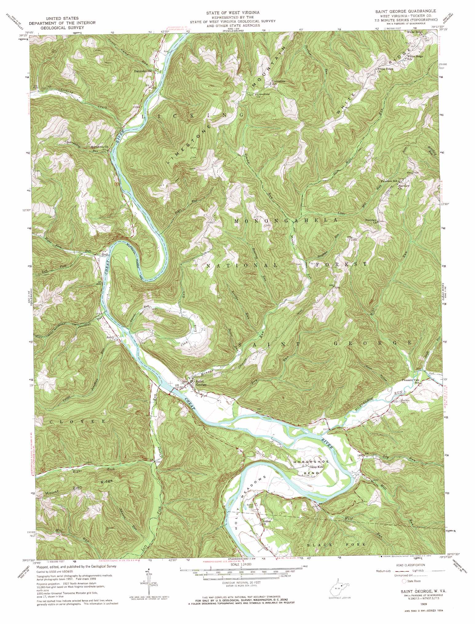
USGS Topo Quad 39079b6 - 1:24,000 scale
| Topo Map Name: | Saint George |
| USGS Topo Quad ID: | 39079b6 |
| Print Size: | ca. 21 1/4" wide x 27" high |
| Southeast Coordinates: | 39.125° N latitude / 79.625° W longitude |
| Map Center Coordinates: | 39.1875° N latitude / 79.6875° W longitude |
| U.S. State: | WV |
| Filename: | o39079b6.jpg |
| Download Map JPG Image: | Saint George topo map 1:24,000 scale |
| Map Type: | Topographic |
| Topo Series: | 7.5´ |
| Map Scale: | 1:24,000 |
| Source of Map Images: | United States Geological Survey (USGS) |
| Alternate Map Versions: |
Saint George WV 1959, updated 1961 Download PDF Buy paper map Saint George WV 1959, updated 1972 Download PDF Buy paper map Saint George WV 1995, updated 1998 Download PDF Buy paper map Saint George WV 2011 Download PDF Buy paper map Saint George WV 2014 Download PDF Buy paper map Saint George WV 2016 Download PDF Buy paper map |
| FStopo: | US Forest Service topo Saint George is available: Download FStopo PDF Download FStopo TIF |
1:24,000 Topo Quads surrounding Saint George
Gladesville |
Newburg |
Kingwood |
Terra Alta |
Oakland |
Thornton |
Fellowsville |
Rowlesburg |
Aurora |
Table Rock |
Nestorville |
Colebank |
Saint George |
Lead Mine |
Davis |
Belington |
Montrose |
Parsons |
Mozark Mountain |
Blackwater Falls |
Junior |
Elkins |
Bowden |
Harman |
Laneville |
> Back to 39079a1 at 1:100,000 scale
> Back to 39078a1 at 1:250,000 scale
> Back to U.S. Topo Maps home
Saint George topo map: Gazetteer
Saint George: Bends
Holly Meadows elevation 499m 1637′Horseshoe Bend elevation 479m 1571′
Saint George: Populated Places
Auvil elevation 473m 1551′Hannahsville elevation 463m 1519′
Holly Meadows elevation 523m 1715′
Location elevation 739m 2424′
Pleasant Vale elevation 500m 1640′
Saint George elevation 476m 1561′
Saint George: Ridges
White Ridge elevation 860m 2821′Saint George: Streams
Bearwallow Run elevation 457m 1499′Bingham Run elevation 544m 1784′
Brannons Run elevation 494m 1620′
Bridge Run elevation 508m 1666′
Bull Run elevation 464m 1522′
Clay Lick Run elevation 467m 1532′
Clover Run elevation 470m 1541′
Drift Run elevation 494m 1620′
Dry Run elevation 475m 1558′
Dry Run elevation 472m 1548′
Horseshoe Run elevation 475m 1558′
Johnson Run elevation 500m 1640′
Jonathan Run elevation 466m 1528′
Laurel Run elevation 472m 1548′
Left Fork Bull Run elevation 474m 1555′
Left Fork Clover Run elevation 484m 1587′
Licking Creek elevation 456m 1496′
Little Mill Run elevation 565m 1853′
Long Run elevation 452m 1482′
Louse Camp Run elevation 453m 1486′
Mike Run elevation 494m 1620′
Mill Run elevation 479m 1571′
Mill Run elevation 561m 1840′
Minear Run elevation 470m 1541′
Right Fork Bull Run elevation 483m 1584′
Right Fork Clover Run elevation 484m 1587′
Roaring Run elevation 515m 1689′
Sailor Run elevation 494m 1620′
Stump Run elevation 561m 1840′
Tobes Run elevation 460m 1509′
Upper Jonathan Run elevation 467m 1532′
Wolf Run elevation 480m 1574′
Saint George: Summits
Limestone Mountain elevation 945m 3100′Saint George: Valleys
Coon Hollow elevation 493m 1617′Saint George digital topo map on disk
Buy this Saint George topo map showing relief, roads, GPS coordinates and other geographical features, as a high-resolution digital map file on DVD:
 map DVD")