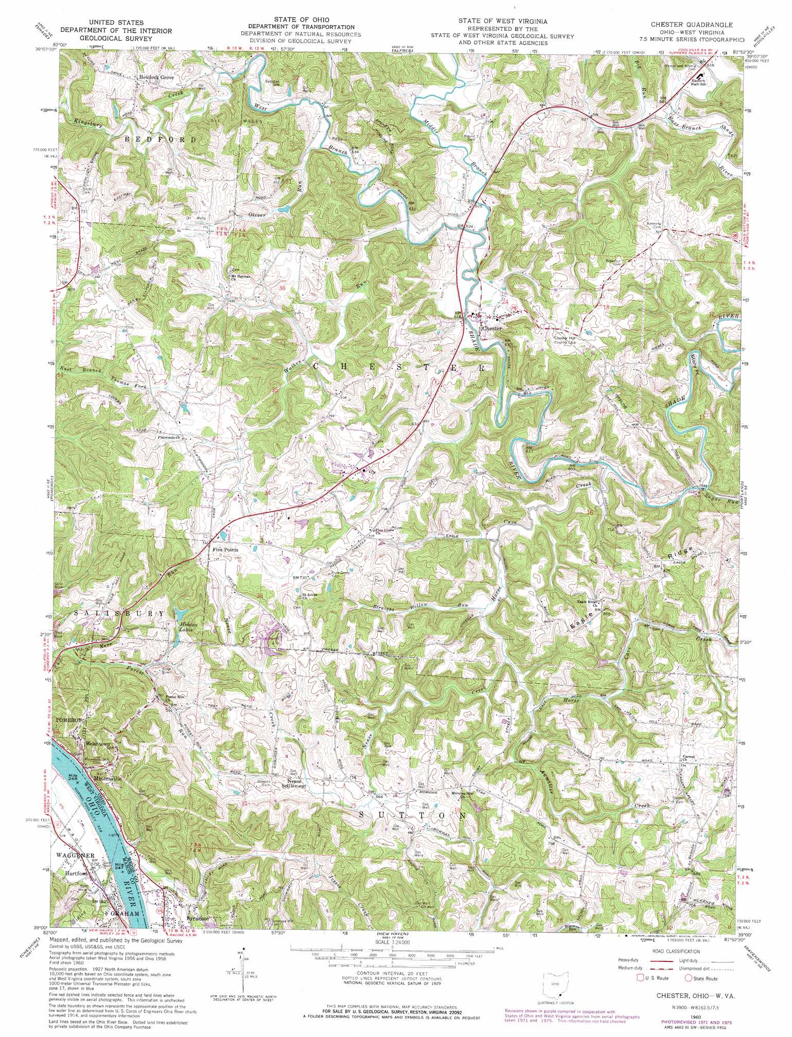
Chester Topo Map Ohio
To zoom in, hover over the map of Chester
USGS Topo Quad 39081a8 - 1:24,000 scale
| Topo Map Name: | Chester |
| USGS Topo Quad ID: | 39081a8 |
| Print Size: | ca. 21 1/4" wide x 27" high |
| Southeast Coordinates: | 39° N latitude / 81.875° W longitude |
| Map Center Coordinates: | 39.0625° N latitude / 81.9375° W longitude |
| U.S. States: | OH, WV |
| Filename: | o39081a8.jpg |
| Download Map JPG Image: | Chester topo map 1:24,000 scale |
| Map Type: | Topographic |
| Topo Series: | 7.5´ |
| Map Scale: | 1:24,000 |
| Source of Map Images: | United States Geological Survey (USGS) |
| Alternate Map Versions: |
Chester OH 1960, updated 1962 Download PDF Buy paper map Chester OH 1960, updated 1973 Download PDF Buy paper map Chester OH 1960, updated 1977 Download PDF Buy paper map Chester OH 1960, updated 1977 Download PDF Buy paper map Chester OH 1994, updated 1998 Download PDF Buy paper map Chester OH 2011 Download PDF Buy paper map Chester OH 2013 Download PDF Buy paper map Chester OH 2016 Download PDF Buy paper map |
1:24,000 Topo Quads surrounding Chester
The Plains |
Athens |
Stewart |
Cutler |
Little Hocking |
Albany |
Shade |
Alfred |
Coolville |
Lubeck |
Rutland |
Pomeroy |
Chester |
Portland |
Pond Creek |
Addison |
Cheshire |
New Haven |
Ravenswood |
Sandyville |
Gallipolis |
Beech Hill |
Mount Alto |
Cottageville |
Ripley |
> Back to 39081a1 at 1:100,000 scale
> Back to 39080a1 at 1:250,000 scale
> Back to U.S. Topo Maps home
Chester topo map: Gazetteer
Chester: Cliffs
Stony Point elevation 202m 662′Chester: Dams
Karr Lake Dam elevation 225m 738′Royal Oak Lake Dam elevation 249m 816′
Chester: Populated Places
Carletonville elevation 175m 574′Chester elevation 190m 623′
Dutchtown elevation 197m 646′
Five Points elevation 223m 731′
Flatwoods elevation 225m 738′
Forest Run elevation 179m 587′
Hartford City elevation 177m 580′
Hemlock Grove elevation 226m 741′
Minersville elevation 175m 574′
Morning Star elevation 225m 738′
Nease Settlement elevation 215m 705′
Welshtown elevation 201m 659′
White Rock (historical) elevation 177m 580′
Chester: Post Offices
Chester Post Office elevation 189m 620′Hemlock Post Office elevation 229m 751′
Minersville Post Office (historical) elevation 175m 574′
Chester: Reservoirs
Hidden Lakes elevation 196m 643′Karr Lake elevation 225m 738′
Royal Oak Lake elevation 249m 816′
Chester: Ridges
Eagle Ridge elevation 251m 823′Chester: Streams
Aumiller Creek elevation 188m 616′Big Run elevation 181m 593′
Horse Cave Creek elevation 181m 593′
Kerr Run elevation 172m 564′
Kingsbury Creek elevation 191m 626′
Middle Branch Shade River elevation 182m 597′
Nease Creek elevation 186m 610′
Oliver Run elevation 189m 620′
Permonkey Creek elevation 167m 547′
Rags Run elevation 181m 593′
Sliding Hill Creek elevation 165m 541′
Straight Hollow Run elevation 184m 603′
Sugar Run elevation 183m 600′
Walker Run elevation 191m 626′
West Branch Shade River elevation 182m 597′
Chester: Summits
Mound Cemetery Mound elevation 205m 672′Welshtown Hill elevation 262m 859′
Chester digital topo map on disk
Buy this Chester topo map showing relief, roads, GPS coordinates and other geographical features, as a high-resolution digital map file on DVD:
 map DVD")