Pleasant Hill East Topo Map Illinois
To zoom in, hover over the map of Pleasant Hill East
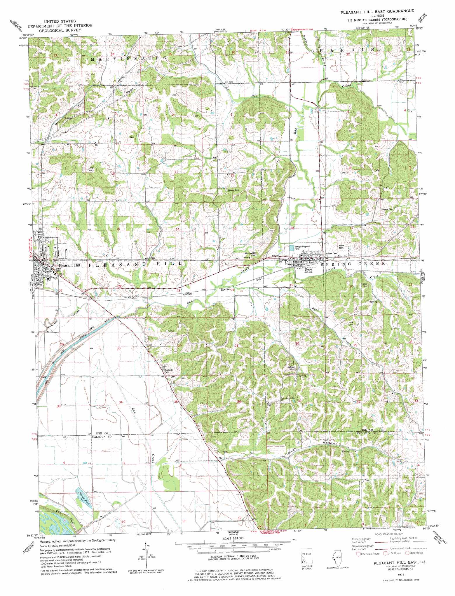
USGS Topo Quad 39090d7 - 1:24,000 scale
| Topo Map Name: | Pleasant Hill East |
| USGS Topo Quad ID: | 39090d7 |
| Print Size: | ca. 21 1/4" wide x 27" high |
| Southeast Coordinates: | 39.375° N latitude / 90.75° W longitude |
| Map Center Coordinates: | 39.4375° N latitude / 90.8125° W longitude |
| U.S. State: | IL |
| Filename: | o39090d7.jpg |
| Download Map JPG Image: | Pleasant Hill East topo map 1:24,000 scale |
| Map Type: | Topographic |
| Topo Series: | 7.5´ |
| Map Scale: | 1:24,000 |
| Source of Map Images: | United States Geological Survey (USGS) |
| Alternate Map Versions: |
Pleasant Hill East IL 1978, updated 1978 Download PDF Buy paper map Pleasant Hill East IL 2012 Download PDF Buy paper map Pleasant Hill East IL 2015 Download PDF Buy paper map |
1:24,000 Topo Quads surrounding Pleasant Hill East
Barry |
Baylis |
New Salem |
Griggsville |
Florence |
Rockport |
Summer Hill |
Pittsfield |
Milton |
Bedford |
Louisana |
Pleasant Hill West |
Pleasant Hill East |
Pearl West |
Pearl East |
Cyrene |
Clarksville |
Annada |
Pleasant Dale Valley |
Kampsville |
Eolia |
Auburn |
Elsberry |
Hamburg |
Hardin |
> Back to 39090a1 at 1:100,000 scale
> Back to 39090a1 at 1:250,000 scale
> Back to U.S. Topo Maps home
Pleasant Hill East topo map: Gazetteer
Pleasant Hill East: Canals
Bay Creek Diversion Ditch elevation 134m 439′Pleasant Hill East: Guts
Crooked Slough elevation 137m 449′Pleasant Hill East: Lakes
Dolman Pond elevation 134m 439′Round Pond (historical) elevation 136m 446′
Twin Ponds (historical) elevation 134m 439′
Pleasant Hill East: Populated Places
Nebo elevation 148m 485′Pleasant Hill elevation 143m 469′
Pleasant Hill East: Streams
Buck Branch elevation 143m 469′Buckeye Creek elevation 152m 498′
Cold Run elevation 151m 495′
Honey Creek elevation 152m 498′
Spring Creek elevation 146m 479′
Pleasant Hill East: Valleys
Howell Hollow elevation 147m 482′Pleasant Hill East digital topo map on disk
Buy this Pleasant Hill East topo map showing relief, roads, GPS coordinates and other geographical features, as a high-resolution digital map file on DVD: