Cisco Grove Topo Map California
To zoom in, hover over the map of Cisco Grove
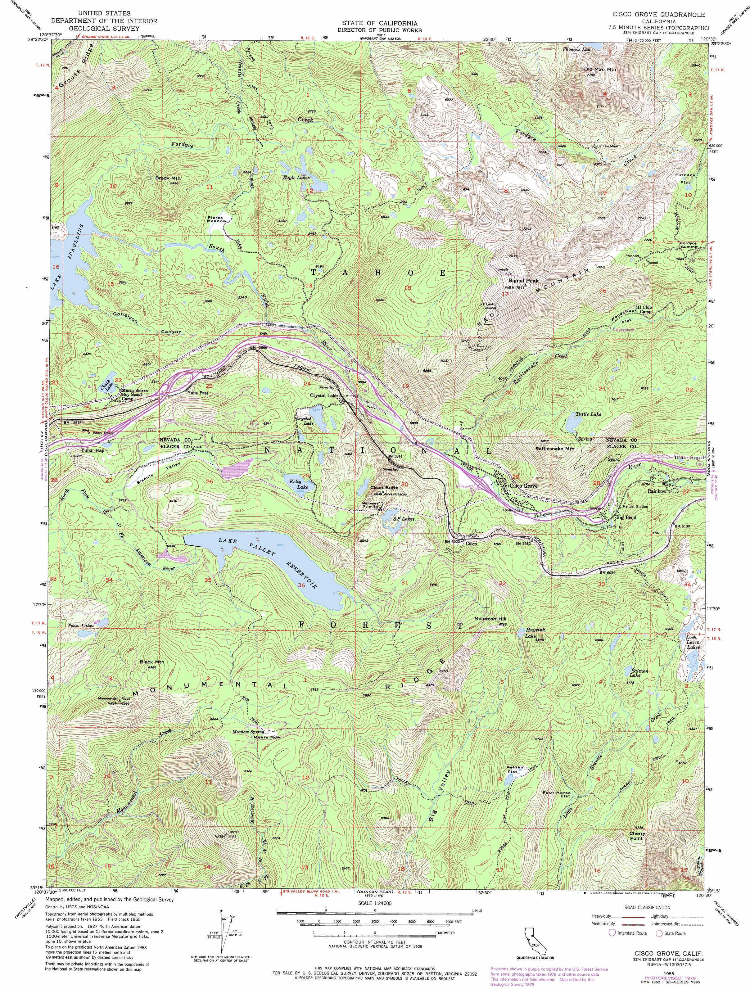
USGS Topo Quad 39120c5 - 1:24,000 scale
| Topo Map Name: | Cisco Grove |
| USGS Topo Quad ID: | 39120c5 |
| Print Size: | ca. 21 1/4" wide x 27" high |
| Southeast Coordinates: | 39.25° N latitude / 120.5° W longitude |
| Map Center Coordinates: | 39.3125° N latitude / 120.5625° W longitude |
| U.S. State: | CA |
| Filename: | o39120c5.jpg |
| Download Map JPG Image: | Cisco Grove topo map 1:24,000 scale |
| Map Type: | Topographic |
| Topo Series: | 7.5´ |
| Map Scale: | 1:24,000 |
| Source of Map Images: | United States Geological Survey (USGS) |
| Alternate Map Versions: |
Cisco Grove CA 1955, updated 1956 Download PDF Buy paper map Cisco Grove CA 1955, updated 1956 Download PDF Buy paper map Cisco Grove CA 1955, updated 1961 Download PDF Buy paper map Cisco Grove CA 1955, updated 1974 Download PDF Buy paper map Cisco Grove CA 1955, updated 1976 Download PDF Buy paper map Cisco Grove CA 1955, updated 1976 Download PDF Buy paper map Cisco Grove CA 1955, updated 1980 Download PDF Buy paper map Cisco Grove CA 1955, updated 1980 Download PDF Buy paper map Cisco Grove CA 1955, updated 1980 Download PDF Buy paper map Cisco Grove CA 2000, updated 2003 Download PDF Buy paper map Cisco Grove CA 2000, updated 2006 Download PDF Buy paper map Cisco Grove CA 2012 Download PDF Buy paper map Cisco Grove CA 2015 Download PDF Buy paper map |
| FStopo: | US Forest Service topo Cisco Grove is available: Download FStopo PDF Download FStopo TIF |
1:24,000 Topo Quads surrounding Cisco Grove
Downieville |
Sierra City |
Haypress Valley |
Sattley |
Sierraville |
Alleghany |
Graniteville |
English Mountain |
Webber Peak |
Independence Lake |
Washington |
Blue Canyon |
Cisco Grove |
Soda Springs |
Norden |
Dutch Flat |
Westville |
Duncan Peak |
Royal Gorge |
Granite Chief |
Foresthill |
Michigan Bluff |
Greek Store |
Bunker Hill |
Wentworth Springs |
> Back to 39120a1 at 1:100,000 scale
> Back to 39120a1 at 1:250,000 scale
> Back to U.S. Topo Maps home
Cisco Grove topo map: Gazetteer
Cisco Grove: Basins
Big Valley elevation 1722m 5649′Lake Valley elevation 1765m 5790′
Cisco Grove: Dams
Kelly Lake 97-024 Dam elevation 1798m 5898′Lake Valley 97-032 Dam elevation 1762m 5780′
Snowflower 1323 Dam elevation 1763m 5784′
Cisco Grove: Flats
Furnace Flat elevation 2043m 6702′Mears Meadow elevation 2044m 6706′
Pelham Flat elevation 1934m 6345′
Pierce Meadow elevation 1569m 5147′
Woodchuck Flat elevation 1907m 6256′
Cisco Grove: Gaps
Yuba Gap elevation 1765m 5790′Cisco Grove: Lakes
Chubb Lake elevation 1640m 5380′Eagle Lakes elevation 1652m 5419′
Huysink Lake elevation 1968m 6456′
Kelly Lake elevation 1797m 5895′
Loch Leven Lakes elevation 2088m 6850′
Salmon Lake elevation 2044m 6706′
Tuttle Lake elevation 2030m 6660′
Twin Lakes elevation 1816m 5958′
Cisco Grove: Populated Places
Big Bend elevation 1749m 5738′Cisco elevation 1810m 5938′
Cisco Grove elevation 1720m 5643′
Crystal Lake elevation 1749m 5738′
Rainbow elevation 1762m 5780′
Yuba Pass elevation 1718m 5636′
Cisco Grove: Reservoirs
Crystal Lake elevation 1795m 5889′Lake Valley Reservoir elevation 1765m 5790′
S P Lakes elevation 1928m 6325′
Cisco Grove: Ridges
Grouse Ridge elevation 2181m 7155′Monumental Ridge elevation 2106m 6909′
Cisco Grove: Springs
Meadow Spring elevation 2034m 6673′Cisco Grove: Streams
Fordyce Creek elevation 1530m 5019′Granite Creek elevation 1642m 5387′
Rattlesnake Creek elevation 1710m 5610′
Cisco Grove: Summits
Black Mountain elevation 2131m 6991′Brady Mountain elevation 1814m 5951′
Cherry Point elevation 2048m 6719′
Cisco Butte elevation 2015m 6610′
Fordyce Summit elevation 2196m 7204′
McIntosh Hill elevation 2064m 6771′
Old Man Mountain elevation 2362m 7749′
Quartz Mountain elevation 2125m 6971′
Rattlesnake Mountain elevation 2118m 6948′
Red Mountain elevation 2388m 7834′
Signal Peak elevation 2374m 7788′
Cisco Grove: Trails
Big Valley Trail elevation 1827m 5994′Blue Lake Trail elevation 1998m 6555′
Cherry Point Trail elevation 2025m 6643′
Grouse Ridge Trail elevation 1648m 5406′
Loch Leven Trail elevation 1959m 6427′
Mears Lake Valley Trail elevation 2018m 6620′
Overland Emigrant Trail elevation 1832m 6010′
Salmon Lake Trail elevation 2060m 6758′
Spaulding Lake Trail elevation 1563m 5127′
Sugar Pine Point Trail elevation 1938m 6358′
Cisco Grove: Valleys
Gonelson Canyon elevation 1535m 5036′Sixmile Valley elevation 1706m 5597′
Cisco Grove digital topo map on disk
Buy this Cisco Grove topo map showing relief, roads, GPS coordinates and other geographical features, as a high-resolution digital map file on DVD: