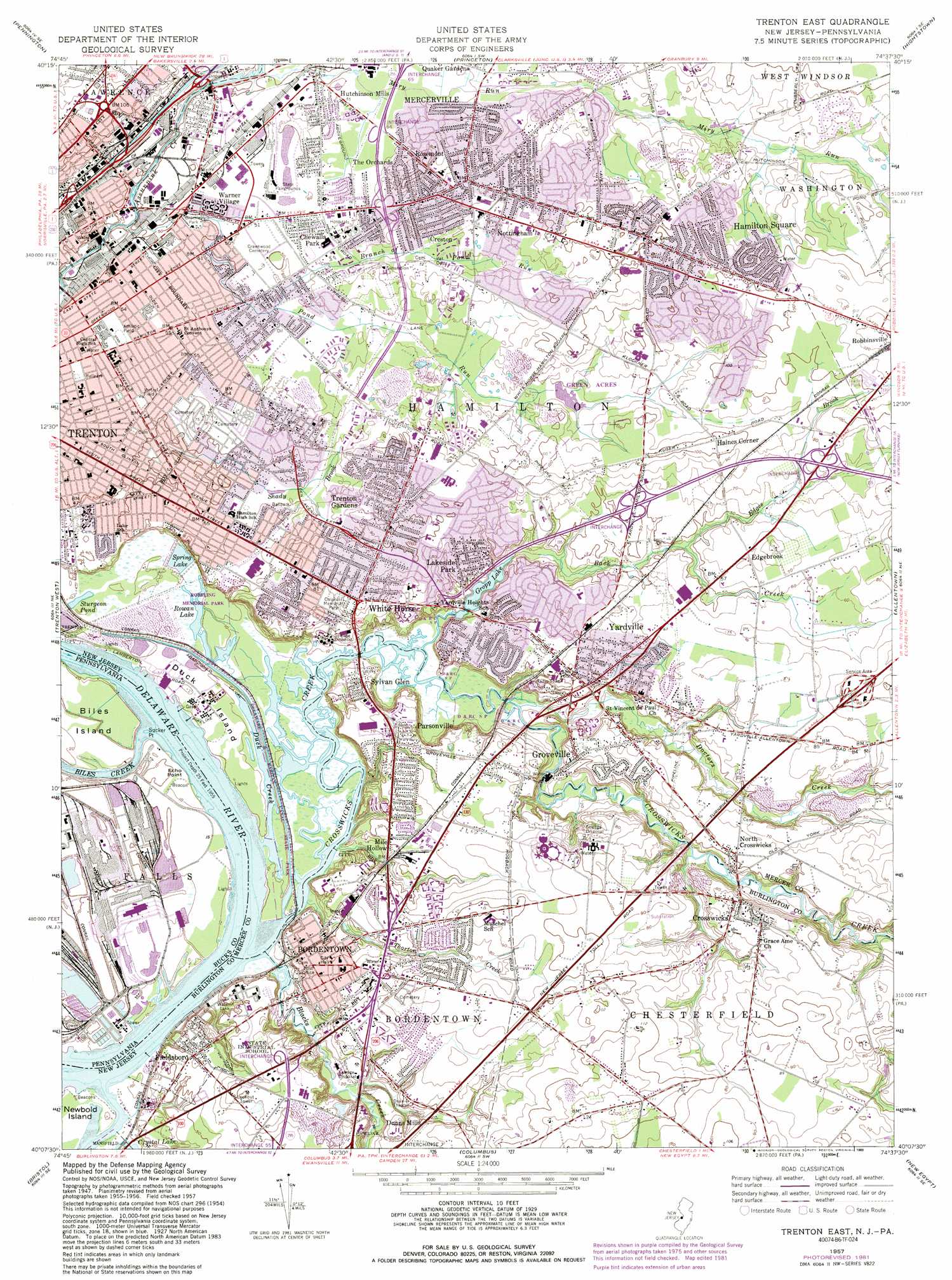
Trenton East Topo Map New Jersey
To zoom in, hover over the map of Trenton East
USGS Topo Quad 40074b6 - 1:24,000 scale
| Topo Map Name: | Trenton East |
| USGS Topo Quad ID: | 40074b6 |
| Print Size: | ca. 21 1/4" wide x 27" high |
| Southeast Coordinates: | 40.125° N latitude / 74.625° W longitude |
| Map Center Coordinates: | 40.1875° N latitude / 74.6875° W longitude |
| U.S. States: | NJ, PA |
| Filename: | o40074b6.jpg |
| Download Map JPG Image: | Trenton East topo map 1:24,000 scale |
| Map Type: | Topographic |
| Topo Series: | 7.5´ |
| Map Scale: | 1:24,000 |
| Source of Map Images: | United States Geological Survey (USGS) |
| Alternate Map Versions: |
Trenton East NJ 1947 Download PDF Buy paper map Trenton East NJ 1957, updated 1960 Download PDF Buy paper map Trenton East NJ 1957, updated 1967 Download PDF Buy paper map Trenton East NJ 1957, updated 1972 Download PDF Buy paper map Trenton East NJ 1957, updated 1982 Download PDF Buy paper map Trenton East NJ 1957, updated 1989 Download PDF Buy paper map Trenton East NJ 1957, updated 1989 Download PDF Buy paper map Trenton East NJ 1995, updated 2000 Download PDF Buy paper map Trenton East NJ 2011 Download PDF Buy paper map Trenton East NJ 2014 Download PDF Buy paper map Trenton East NJ 2016 Download PDF Buy paper map |
1:24,000 Topo Quads surrounding Trenton East
Stockton |
Hopewell |
Rocky Hill |
Monmouth Junction |
New Brunswick |
Lambertville |
Pennington |
Princeton |
Hightstown |
Jamesburg |
Langhorne |
Trenton West |
Trenton East |
Allentown |
Roosevelt |
Beverly |
Bristol |
Columbus |
New Egypt |
Cassville |
Moorestown |
Mount Holly |
Pemberton |
Browns Mills |
Whiting |
> Back to 40074a1 at 1:100,000 scale
> Back to 40074a1 at 1:250,000 scale
> Back to U.S. Topo Maps home
Trenton East topo map: Gazetteer
Trenton East: Airports
Saint Francis Medical Center Helistop elevation 17m 55′Trenton East: Capes
Biles Point elevation 0m 0′Echo Point elevation 2m 6′
Sucker Point elevation 3m 9′
Trenton East: Channels
Biles Island Channel elevation 2m 6′Biles Island Channel elevation 2m 6′
Blake Channel elevation 2m 6′
Bordentown Range elevation 2m 6′
Bordentown Range elevation 2m 6′
Duck Island Range elevation 2m 6′
Duck Island Range elevation 2m 6′
Perriwig Channel elevation 2m 6′
Perriwig Channel elevation 2m 6′
Raritan Channel elevation 2m 6′
Raritan Channel elevation 2m 6′
Whitehill Range elevation 2m 6′
Whitehill Range elevation 2m 6′
Trenton East: Dams
Crystal Lake Dam elevation 1m 3′Gropp Lake Dam elevation 2m 6′
Herzenberg Dam elevation 33m 108′
Whitehead Pond Dam elevation 10m 32′
Trenton East: Guts
Duck Creek elevation 3m 9′Trenton East: Islands
Biles Island elevation 6m 19′Duck Island elevation 3m 9′
Starveout Island (historical) elevation 3m 9′
Trenton East: Lakes
Rowan Lake elevation 0m 0′Trenton East: Parks
Assunpink Park elevation 16m 52′Bromley Park elevation 16m 52′
Colonial Memorial Park elevation 25m 82′
Hamilton Park elevation 28m 91′
Wetzel Field elevation 15m 49′
Trenton East: Populated Places
Bordentown elevation 16m 52′Bossert Estates elevation 19m 62′
Briar Manor elevation 25m 82′
Chewalla Park elevation 16m 52′
Creston elevation 22m 72′
Crosswicks elevation 23m 75′
Dunns Mills elevation 11m 36′
Edgebrook elevation 21m 68′
Fieldsboro elevation 19m 62′
Golden Crest elevation 30m 98′
Groveville elevation 16m 52′
Haines Corner elevation 32m 104′
Hamilton Square elevation 31m 101′
Harneys Corner elevation 26m 85′
Hutchinson Mills elevation 16m 52′
Lakeside Park elevation 21m 68′
Mercerville elevation 28m 91′
Mile Hollow elevation 15m 49′
North Crosswicks elevation 16m 52′
Nottingham elevation 25m 82′
Parsonville elevation 15m 49′
Rosemont elevation 32m 104′
Sylvan Glen elevation 15m 49′
The Orchards elevation 24m 78′
Trenton elevation 17m 55′
Trenton Gardens elevation 29m 95′
Warner Village elevation 15m 49′
White Horse elevation 26m 85′
Yardville elevation 21m 68′
Yardville Heights elevation 17m 55′
Trenton East: Reservoirs
Crystal Lake elevation 0m 0′Gropp Lake elevation 2m 6′
Spring Lake elevation 1m 3′
Sturgeon Pond elevation 1m 3′
Whitehead Pond elevation 10m 32′
Trenton East: Streams
Back Creek elevation 1m 3′Biles Creek elevation 2m 6′
Blacks Creek elevation 1m 3′
Branch of Pond Run elevation 17m 55′
Crosswicks Creek elevation 0m 0′
Doctors Creek elevation 2m 6′
Edges Brook elevation 11m 36′
Miry Run elevation 13m 42′
Pond Run elevation 12m 39′
Thorton Creek elevation 1m 3′
Trenton East digital topo map on disk
Buy this Trenton East topo map showing relief, roads, GPS coordinates and other geographical features, as a high-resolution digital map file on DVD:
Atlantic Coast (NY, NJ, PA, DE, MD, VA, NC)
Buy digital topo maps: Atlantic Coast (NY, NJ, PA, DE, MD, VA, NC)
 map DVD")