Princeton Topo Map New Jersey
To zoom in, hover over the map of Princeton
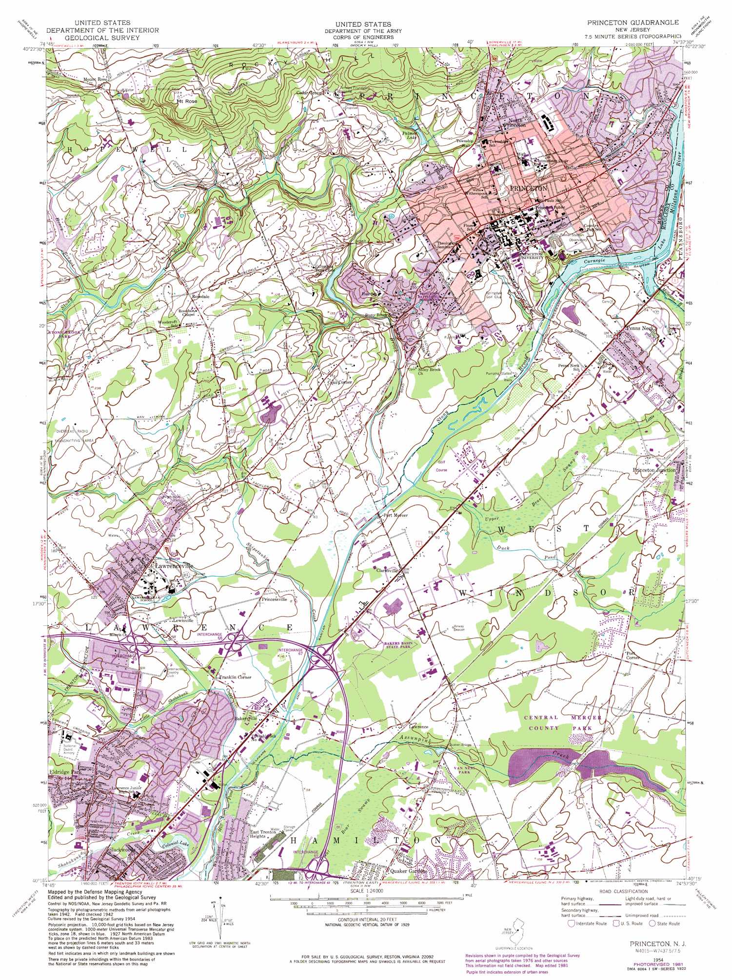
USGS Topo Quad 40074c6 - 1:24,000 scale
| Topo Map Name: | Princeton |
| USGS Topo Quad ID: | 40074c6 |
| Print Size: | ca. 21 1/4" wide x 27" high |
| Southeast Coordinates: | 40.25° N latitude / 74.625° W longitude |
| Map Center Coordinates: | 40.3125° N latitude / 74.6875° W longitude |
| U.S. State: | NJ |
| Filename: | o40074c6.jpg |
| Download Map JPG Image: | Princeton topo map 1:24,000 scale |
| Map Type: | Topographic |
| Topo Series: | 7.5´ |
| Map Scale: | 1:24,000 |
| Source of Map Images: | United States Geological Survey (USGS) |
| Alternate Map Versions: |
Princeton NJ 1952 Download PDF Buy paper map Princeton NJ 1954, updated 1956 Download PDF Buy paper map Princeton NJ 1954, updated 1962 Download PDF Buy paper map Princeton NJ 1954, updated 1972 Download PDF Buy paper map Princeton NJ 1954, updated 1982 Download PDF Buy paper map Princeton NJ 1995, updated 2000 Download PDF Buy paper map Princeton NJ 2011 Download PDF Buy paper map Princeton NJ 2014 Download PDF Buy paper map Princeton NJ 2016 Download PDF Buy paper map |
1:24,000 Topo Quads surrounding Princeton
Pittstown |
Flemington |
Raritan |
Bound Brook |
Plainfield |
Stockton |
Hopewell |
Rocky Hill |
Monmouth Junction |
New Brunswick |
Lambertville |
Pennington |
Princeton |
Hightstown |
Jamesburg |
Langhorne |
Trenton West |
Trenton East |
Allentown |
Roosevelt |
Beverly |
Bristol |
Columbus |
New Egypt |
Cassville |
> Back to 40074a1 at 1:100,000 scale
> Back to 40074a1 at 1:250,000 scale
> Back to U.S. Topo Maps home
Princeton topo map: Gazetteer
Princeton: Airports
American Cyanamid Helistop elevation 30m 98′Bristol-Myers/Squibb Heliport elevation 47m 154′
Carnegie Center Heliport elevation 30m 98′
Congoleum Helistop elevation 14m 45′
Educational Testing Heliport elevation 55m 180′
PSE and G Trenton Distribution Helistop elevation 26m 85′
RCA Princeton Heliport elevation 30m 98′
Princeton: Bridges
Quaker Bridge elevation 18m 59′Princeton: Crossings
Interchange 65 elevation 16m 52′Interchange 67 elevation 16m 52′
Interchange 7 elevation 36m 118′
Interchange 8 elevation 25m 82′
Princeton: Dams
Colonial Lake Dam elevation 12m 39′Stony Brook Watershed Dam Fourteen elevation 36m 118′
Princeton: Lakes
Honey Lake elevation 37m 121′Mountain Lake elevation 49m 160′
Palmer Lake elevation 32m 104′
Princeton: Parks
Cannon Green elevation 61m 200′Central Park elevation 31m 101′
Colonial Lake Park elevation 12m 39′
DeNunzio Pool elevation 31m 101′
Marquard Park elevation 55m 180′
Mercer County Park elevation 23m 75′
Palmer Square elevation 58m 190′
Palmer Stadium (historical) elevation 36m 118′
Princeton Battle Monument elevation 61m 200′
Princeton Battlefield State Park elevation 34m 111′
Princeton Metro Park elevation 19m 62′
Scudder Plaza elevation 62m 203′
Turtleback Park elevation 25m 82′
Van Horn Park elevation 17m 55′
Vannest State Wildlife Management Area elevation 18m 59′
Veterans Park elevation 30m 98′
Village Park elevation 51m 167′
Princeton: Populated Places
Bakersville elevation 15m 49′Cedar Grove elevation 66m 216′
Clarksville elevation 27m 88′
Colonial Lake Lands elevation 25m 82′
Coxs Corner elevation 54m 177′
East Trenton Heights elevation 13m 42′
Eldridge Park elevation 30m 98′
Franklin Corner elevation 21m 68′
Lawrence elevation 18m 59′
Lawrenceville elevation 37m 121′
Lewisville elevation 33m 108′
Mount Rose elevation 90m 295′
North Princeton elevation 54m 177′
Penns Neck elevation 31m 101′
Port Mercer elevation 14m 45′
Post Corner elevation 28m 91′
Princessville elevation 25m 82′
Princeton elevation 62m 203′
Quaker Gardens elevation 20m 65′
Rosedale elevation 49m 160′
Slackwoods elevation 25m 82′
Sturwood Hamlet elevation 31m 101′
Princeton: Reservoirs
Colonial Lake elevation 12m 39′Mercer County Lake elevation 18m 59′
Stony Brook Fourteen Basin elevation 36m 118′
Princeton: Streams
Bridegroom Run elevation 17m 55′Duck Pond Run elevation 13m 42′
Harrys Brook elevation 16m 52′
Honey Branch elevation 34m 111′
Little Shabakunk Creek elevation 13m 42′
Shabakunk Creek elevation 13m 42′
Shipetaukin Creek elevation 13m 42′
Stony Brook elevation 15m 49′
Strawberry Run elevation 20m 65′
West Branch Shabakunk Creek elevation 17m 55′
Princeton: Summits
Mount Rose elevation 126m 413′Princeton: Swamps
Great Bear Swamp elevation 17m 55′Upper Bear Swamp elevation 18m 59′
Princeton digital topo map on disk
Buy this Princeton topo map showing relief, roads, GPS coordinates and other geographical features, as a high-resolution digital map file on DVD:
Atlantic Coast (NY, NJ, PA, DE, MD, VA, NC)
Buy digital topo maps: Atlantic Coast (NY, NJ, PA, DE, MD, VA, NC)
 map DVD")