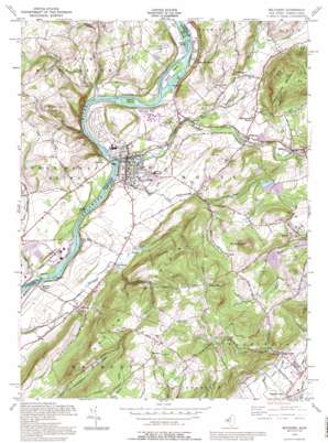
Belvidere Topo Map New Jersey
To zoom in, hover over the map of Belvidere
USGS Topo Quad 40075g1 - 1:24,000 scale
| Topo Map Name: | Belvidere |
| USGS Topo Quad ID: | 40075g1 |
| Print Size: | ca. 21 1/4" wide x 27" high |
| Southeast Coordinates: | 40.75° N latitude / 75° W longitude |
| Map Center Coordinates: | 40.8125° N latitude / 75.0625° W longitude |
| U.S. States: | NJ, PA |
| Filename: | o40075g1.jpg |
| Download Map JPG Image: | Belvidere topo map 1:24,000 scale |
| Map Type: | Topographic |
| Topo Series: | 7.5´ |
| Map Scale: | 1:24,000 |
| Source of Map Images: | United States Geological Survey (USGS) |
| Alternate Map Versions: |
Belvidere NJ 1953 Download PDF Buy paper map Belvidere NJ 1955, updated 1956 Download PDF Buy paper map Belvidere NJ 1955, updated 1965 Download PDF Buy paper map Belvidere NJ 1955, updated 1974 Download PDF Buy paper map Belvidere NJ 1955, updated 1979 Download PDF Buy paper map Belvidere NJ 1955, updated 1984 Download PDF Buy paper map Belvidere NJ 1955, updated 1988 Download PDF Buy paper map Belvidere NJ 1992, updated 1995 Download PDF Buy paper map Belvidere NJ 1997, updated 1999 Download PDF Buy paper map Belvidere NJ 2011 Download PDF Buy paper map Belvidere NJ 2014 Download PDF Buy paper map Belvidere NJ 2016 Download PDF Buy paper map |
1:24,000 Topo Quads surrounding Belvidere
> Back to 40075e1 at 1:100,000 scale
> Back to 40074a1 at 1:250,000 scale
> Back to U.S. Topo Maps home
Belvidere topo map: Gazetteer
Belvidere: Airports
Johnson Farms Airport elevation 329m 1079′Martins Creek Airport (historical) elevation 103m 337′
Matthews Airport elevation 263m 862′
Belvidere: Bars
Macks Bar elevation 77m 252′Belvidere: Channels
Foul Rift elevation 61m 200′Belvidere: Dams
Angens Pond Dam elevation 269m 882′Belvidere: Falls
Foul Rift Falls elevation 79m 259′Belvidere: Islands
Attins Islands elevation 72m 236′Capush Island elevation 68m 223′
Dildine Island elevation 72m 236′
Foul Rift Islands elevation 61m 200′
Foul Rift Islands elevation 61m 200′
Macks Island elevation 89m 291′
Masons Island elevation 68m 223′
McElhaneys Island elevation 66m 216′
Thomas Island elevation 73m 239′
Belvidere: Mines
Oxford Quarry elevation 175m 574′Belvidere: Parks
Mount Jack County Park elevation 88m 288′Belvidere: Populated Places
Belvidere elevation 79m 259′Brass Castle elevation 145m 475′
Bridgeville elevation 110m 360′
Buttzville elevation 123m 403′
Cornish elevation 241m 790′
Foul Rift elevation 73m 239′
Hartzells Ferry elevation 86m 282′
Hazen elevation 128m 419′
Lommasons Glen elevation 99m 324′
Manunka Chunk elevation 95m 311′
Montana elevation 340m 1115′
Pleasant Valley elevation 137m 449′
Riverton elevation 75m 246′
Roxburg elevation 98m 321′
Sarepta elevation 115m 377′
Summerfield elevation 293m 961′
Belvidere: Reservoirs
Angens Pond elevation 269m 882′Belvidere: Streams
Allegheny Creek elevation 70m 229′Beaver Brook elevation 91m 298′
Mill Creek elevation 69m 226′
Oughoughton Creek elevation 62m 203′
Pequest River elevation 74m 242′
Pophandusing Brook elevation 79m 259′
Belvidere: Summits
Mount Jack elevation 258m 846′Mount No More elevation 348m 1141′
Ott Hill elevation 251m 823′
Belvidere digital topo map on disk
Buy this Belvidere topo map showing relief, roads, GPS coordinates and other geographical features, as a high-resolution digital map file on DVD:
Atlantic Coast (NY, NJ, PA, DE, MD, VA, NC)
Buy digital topo maps: Atlantic Coast (NY, NJ, PA, DE, MD, VA, NC)


