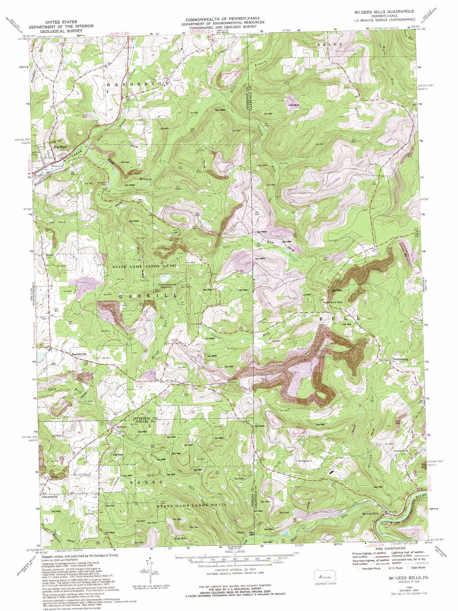
Mcgees Mills Topo Map Pennsylvania
To zoom in, hover over the map of Mcgees Mills
USGS Topo Quad 40078h7 - 1:24,000 scale
| Topo Map Name: | Mcgees Mills |
| USGS Topo Quad ID: | 40078h7 |
| Print Size: | ca. 21 1/4" wide x 27" high |
| Southeast Coordinates: | 40.875° N latitude / 78.75° W longitude |
| Map Center Coordinates: | 40.9375° N latitude / 78.8125° W longitude |
| U.S. State: | PA |
| Filename: | o40078h7.jpg |
| Download Map JPG Image: | Mcgees Mills topo map 1:24,000 scale |
| Map Type: | Topographic |
| Topo Series: | 7.5´ |
| Map Scale: | 1:24,000 |
| Source of Map Images: | United States Geological Survey (USGS) |
| Alternate Map Versions: |
Mc Gees Mills PA 1968, updated 1971 Download PDF Buy paper map Mc Gees Mills PA 1968, updated 1975 Download PDF Buy paper map Mc Gees Mills PA 1968, updated 1982 Download PDF Buy paper map Mc Gees Mills PA 1968, updated 1989 Download PDF Buy paper map Mc Gees Mills PA 1968, updated 1994 Download PDF Buy paper map McGees Mills PA 2010 Download PDF Buy paper map McGees Mills PA 2013 Download PDF Buy paper map McGees Mills PA 2016 Download PDF Buy paper map |
1:24,000 Topo Quads surrounding Mcgees Mills
Brookville |
Hazen |
Falls Creek |
Sabula |
Penfield |
Coolspring |
Reynoldsville |
Du Bois |
Luthersburg |
Elliott Park |
Valier |
Punxsutawney |
Mcgees Mills |
Mahaffey |
Curwensville |
Marion Center |
Rochester Mills |
Burnside |
Westover |
Irvona |
Clymer |
Commodore |
Barnesboro |
Hastings |
Coalport |
> Back to 40078e1 at 1:100,000 scale
> Back to 40078a1 at 1:250,000 scale
> Back to U.S. Topo Maps home
Mcgees Mills topo map: Gazetteer
Mcgees Mills: Dams
Clover Dam elevation 470m 1541′Mcgees Mills: Parks
State Game Lands Number 174 elevation 611m 2004′State Game Lands Number 195 elevation 443m 1453′
Mcgees Mills: Populated Places
Bowersville elevation 555m 1820′Clover Run elevation 626m 2053′
Flora elevation 585m 1919′
Hillman elevation 583m 1912′
Keal Run elevation 501m 1643′
McGees Mills elevation 394m 1292′
Newtonburg elevation 562m 1843′
Sidney elevation 453m 1486′
Mcgees Mills: Reservoirs
Punxsutawney Reservoir elevation 470m 1541′Mcgees Mills: Streams
Bear Run elevation 391m 1282′Clover Run elevation 399m 1309′
East Branch Mahoning Creek elevation 395m 1295′
Laurel Run elevation 420m 1377′
Lost Run elevation 496m 1627′
South Branch Bear Run elevation 444m 1456′
Stony Run elevation 475m 1558′
Stump Creek elevation 395m 1295′
Whisky Run elevation 389m 1276′
Mcgees Mills digital topo map on disk
Buy this Mcgees Mills topo map showing relief, roads, GPS coordinates and other geographical features, as a high-resolution digital map file on DVD:
 map DVD")