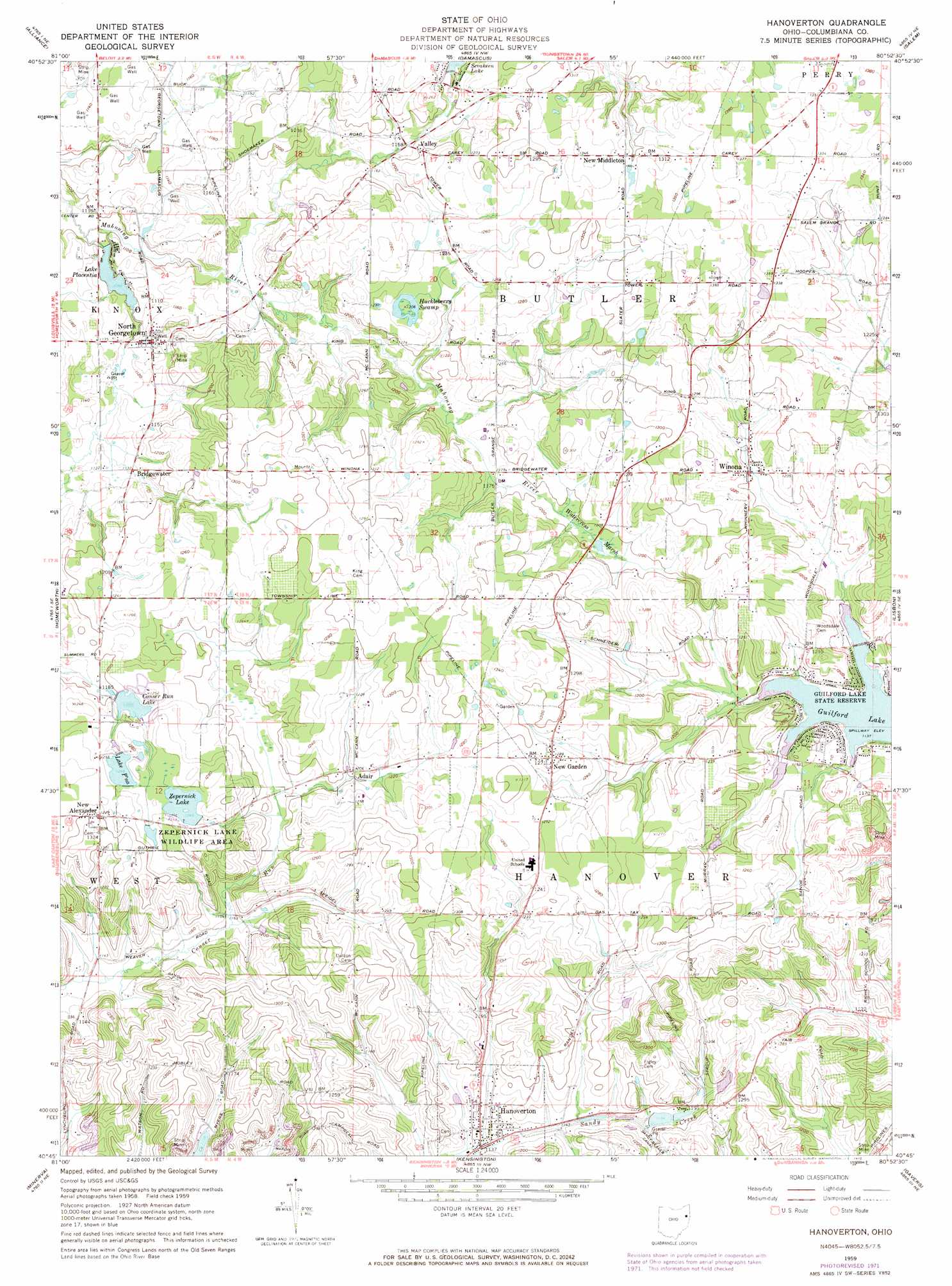
Hanoverton Topo Map Ohio
To zoom in, hover over the map of Hanoverton
USGS Topo Quad 40080g8 - 1:24,000 scale
| Topo Map Name: | Hanoverton |
| USGS Topo Quad ID: | 40080g8 |
| Print Size: | ca. 21 1/4" wide x 27" high |
| Southeast Coordinates: | 40.75° N latitude / 80.875° W longitude |
| Map Center Coordinates: | 40.8125° N latitude / 80.9375° W longitude |
| U.S. State: | OH |
| Filename: | o40080g8.jpg |
| Download Map JPG Image: | Hanoverton topo map 1:24,000 scale |
| Map Type: | Topographic |
| Topo Series: | 7.5´ |
| Map Scale: | 1:24,000 |
| Source of Map Images: | United States Geological Survey (USGS) |
| Alternate Map Versions: |
Hanoverton OH 1959, updated 1961 Download PDF Buy paper map Hanoverton OH 1959, updated 1972 Download PDF Buy paper map Hanoverton OH 1994, updated 1997 Download PDF Buy paper map Hanoverton OH 2010 Download PDF Buy paper map Hanoverton OH 2013 Download PDF Buy paper map Hanoverton OH 2016 Download PDF Buy paper map |
1:24,000 Topo Quads surrounding Hanoverton
Atwater |
Deerfield |
Lake Milton |
Canfield |
Youngstown |
Limaville |
Alliance |
Damascus |
Salem |
Columbiana |
Robertsville |
Homeworth |
Hanoverton |
Lisbon |
Elkton |
Malvern |
Minerva |
Kensington |
Gavers |
West Point |
Dellroy |
Carrollton |
Bergholz |
Salineville |
Wellsville |
> Back to 40080e1 at 1:100,000 scale
> Back to 40080a1 at 1:250,000 scale
> Back to U.S. Topo Maps home
Hanoverton topo map: Gazetteer
Hanoverton: Dams
Lake Placentia Dam elevation 335m 1099′Lake P'na Dam elevation 377m 1236′
Paradise Lake Dam elevation 370m 1213′
Slates Dam elevation 368m 1207′
Zepernick Lake Dam elevation 383m 1256′
Hanoverton: Lakes
Sevakeen Lake elevation 362m 1187′Hanoverton: Parks
Guilford Lake State Park elevation 344m 1128′Hanoverton Canal Town Historic District elevation 344m 1128′
Zepernick Lake Wildlife Area elevation 387m 1269′
Hanoverton: Populated Places
Adair elevation 366m 1200′Bridgewater elevation 344m 1128′
Hanoverton elevation 344m 1128′
New Alexander elevation 396m 1299′
New Garden elevation 391m 1282′
New Middleton elevation 402m 1318′
North Georgetown elevation 347m 1138′
Valley elevation 352m 1154′
Winona elevation 364m 1194′
Hanoverton: Post Offices
Adair Post Office (historical) elevation 366m 1200′Hanoverton elevation 344m 1128′
Newgarden Post Office (historical) elevation 391m 1282′
North Georgetown Post Office elevation 347m 1138′
Valley Post Office (historical) elevation 352m 1154′
Winona Post Office elevation 365m 1197′
Hanoverton: Reservoirs
Conser Run Lake elevation 365m 1197′Lake Pina elevation 378m 1240′
Lake Placentia elevation 335m 1099′
Lake P'na elevation 377m 1236′
Paradise Lake elevation 370m 1213′
Slates Reservoir elevation 368m 1207′
Zepernick Lake elevation 383m 1256′
Hanoverton: Swamps
Huckleberry Swamp elevation 371m 1217′Watercress Marsh elevation 362m 1187′
Hanoverton digital topo map on disk
Buy this Hanoverton topo map showing relief, roads, GPS coordinates and other geographical features, as a high-resolution digital map file on DVD:
 map DVD")