Crestline Topo Map Ohio
To zoom in, hover over the map of Crestline
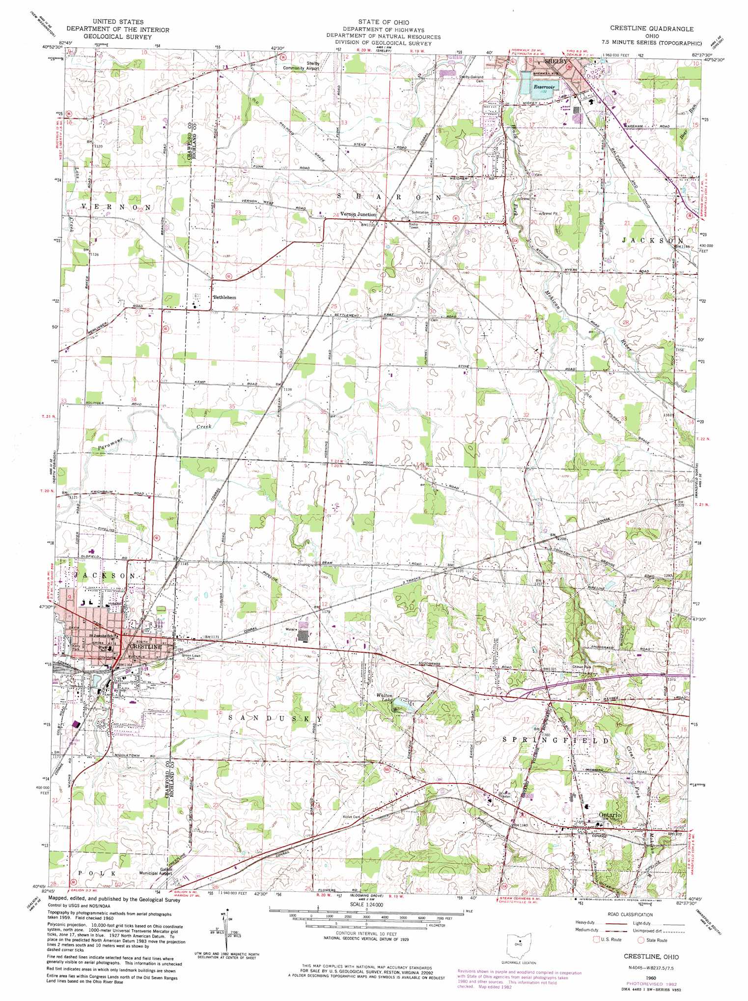
USGS Topo Quad 40082g6 - 1:24,000 scale
| Topo Map Name: | Crestline |
| USGS Topo Quad ID: | 40082g6 |
| Print Size: | ca. 21 1/4" wide x 27" high |
| Southeast Coordinates: | 40.75° N latitude / 82.625° W longitude |
| Map Center Coordinates: | 40.8125° N latitude / 82.6875° W longitude |
| U.S. State: | OH |
| Filename: | o40082g6.jpg |
| Download Map JPG Image: | Crestline topo map 1:24,000 scale |
| Map Type: | Topographic |
| Topo Series: | 7.5´ |
| Map Scale: | 1:24,000 |
| Source of Map Images: | United States Geological Survey (USGS) |
| Alternate Map Versions: |
Crestline OH 1960, updated 1962 Download PDF Buy paper map Crestline OH 1960, updated 1970 Download PDF Buy paper map Crestline OH 1960, updated 1983 Download PDF Buy paper map Crestline OH 2010 Download PDF Buy paper map Crestline OH 2013 Download PDF Buy paper map Crestline OH 2016 Download PDF Buy paper map |
1:24,000 Topo Quads surrounding Crestline
Attica |
Centerton |
Willard |
Greenwich |
New London |
Chatfield |
New Washington |
Shelby |
Shiloh |
Olivesburg |
Bucyrus |
North Robinson |
Crestline |
Mansfield North |
Pavonia |
Caledonia |
Galion |
Blooming Grove |
Mansfield South |
Lucas |
Denmark |
Mount Gilead |
Shauck |
Bellville |
Butler |
> Back to 40082e1 at 1:100,000 scale
> Back to 40082a1 at 1:250,000 scale
> Back to U.S. Topo Maps home
Crestline topo map: Gazetteer
Crestline: Airports
Crestline Hospital Heliport elevation 348m 1141′Galion Municipal Airport elevation 374m 1227′
Shelby Community Airport elevation 341m 1118′
Crestline: Dams
Shelby Upground Reservoir Number One Dam elevation 338m 1108′Shelby Upground Reservoir Number Two Dam elevation 343m 1125′
Crestline: Lakes
Walton Lake elevation 383m 1256′Crestline: Parks
Chever Park elevation 403m 1322′Kelly Park elevation 345m 1131′
Village Park elevation 403m 1322′
Crestline: Populated Places
Bethlehem elevation 346m 1135′Crestline elevation 348m 1141′
East Crestline elevation 356m 1167′
Five Corners elevation 410m 1345′
Hines (historical) elevation 342m 1122′
Meadowood Estates Mobile Home Park elevation 353m 1158′
Mobile Manor Park elevation 351m 1151′
Pinecrest Mobile Home Park elevation 356m 1167′
Riblet (historical) elevation 384m 1259′
Richland (historical) elevation 372m 1220′
Vernon Junction elevation 344m 1128′
Crestline: Post Offices
Crestline Post Office elevation 347m 1138′Riblets Post Office (historical) elevation 384m 1259′
Vernon Junction Post Office (historical) elevation 344m 1128′
Crestline: Reservoirs
Crestline Reservoir elevation 387m 1269′Shelby Upground Reservoir Number One elevation 338m 1108′
Shelby Upground Reservoir Number Two elevation 343m 1125′
Crestline: Springs
Palmer Spring elevation 405m 1328′Crestline: Summits
Ralston Knob elevation 430m 1410′Crestline: Valleys
Shafers Hollow elevation 347m 1138′Crestline digital topo map on disk
Buy this Crestline topo map showing relief, roads, GPS coordinates and other geographical features, as a high-resolution digital map file on DVD:
 map DVD")