Weeping Water Topo Map Nebraska
To zoom in, hover over the map of Weeping Water
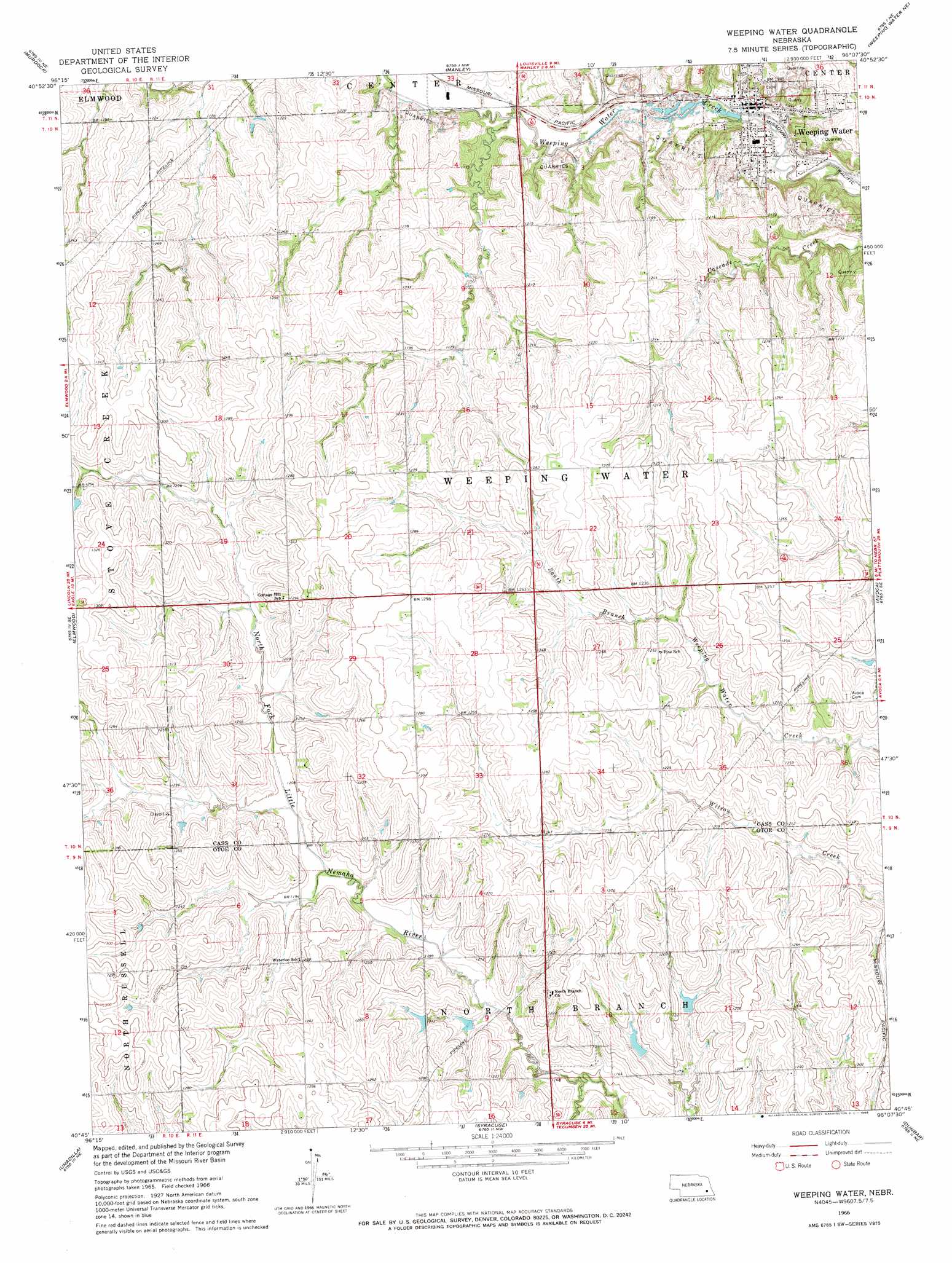
USGS Topo Quad 40096g2 - 1:24,000 scale
| Topo Map Name: | Weeping Water |
| USGS Topo Quad ID: | 40096g2 |
| Print Size: | ca. 21 1/4" wide x 27" high |
| Southeast Coordinates: | 40.75° N latitude / 96.125° W longitude |
| Map Center Coordinates: | 40.8125° N latitude / 96.1875° W longitude |
| U.S. State: | NE |
| Filename: | o40096g2.jpg |
| Download Map JPG Image: | Weeping Water topo map 1:24,000 scale |
| Map Type: | Topographic |
| Topo Series: | 7.5´ |
| Map Scale: | 1:24,000 |
| Source of Map Images: | United States Geological Survey (USGS) |
| Alternate Map Versions: |
Weeping Water NE 1966, updated 1968 Download PDF Buy paper map Weeping Water NE 2011 Download PDF Buy paper map Weeping Water NE 2014 Download PDF Buy paper map |
1:24,000 Topo Quads surrounding Weeping Water
Ashland West |
Ashland East |
Springfield |
Cedar Creek |
Plattsmouth |
Greenwood |
Murdock |
Manley |
Weeping Water Ne |
Murray |
Eagle |
Elmwood |
Weeping Water |
Avoca |
Nehawka |
Palmyra |
Unadilla |
Syracuse |
Dunbar |
Nebraska City Nw |
Douglas |
Burr |
Cook |
Talmage |
Paul |
> Back to 40096e1 at 1:100,000 scale
> Back to 40096a1 at 1:250,000 scale
> Back to U.S. Topo Maps home
Weeping Water topo map: Gazetteer
Weeping Water: Dams
Mohr Dam elevation 363m 1190′Roper Dam elevation 359m 1177′
Wilson Creek Dam 11-A elevation 373m 1223′
Wilson Creek Dam 12-11 elevation 358m 1174′
Wilson Creek Dam 12-17 elevation 371m 1217′
Wilson Creek Dam 12-6 elevation 360m 1181′
Wilson Creek Dam 12-9B elevation 362m 1187′
Wilson Creek Dam 12-S elevation 369m 1210′
Wilson Creek Dam 12-T elevation 363m 1190′
Weeping Water: Parks
Weeping Water Academy Historical Marker elevation 338m 1108′Weeping Water: Populated Places
Weeping Water elevation 335m 1099′Weeping Water: Post Offices
Weeping Water Post Office elevation 329m 1079′Weeping Water: Reservoirs
Wilson Creek Reservoir 11-A elevation 373m 1223′Wilson Creek Reservoir 12-11 elevation 358m 1174′
Wilson Creek Reservoir 12-16 elevation 359m 1177′
Wilson Creek Reservoir 12-17 elevation 371m 1217′
Wilson Creek Reservoir 12-18 elevation 363m 1190′
Wilson Creek Reservoir 12-6 elevation 360m 1181′
Wilson Creek Reservoir 12-9B elevation 362m 1187′
Wilson Creek Reservoir 12-S elevation 369m 1210′
Wilson Creek Reservoir 12-T elevation 363m 1190′
Weeping Water digital topo map on disk
Buy this Weeping Water topo map showing relief, roads, GPS coordinates and other geographical features, as a high-resolution digital map file on DVD: