Trail Mountain Topo Map Colorado
To zoom in, hover over the map of Trail Mountain
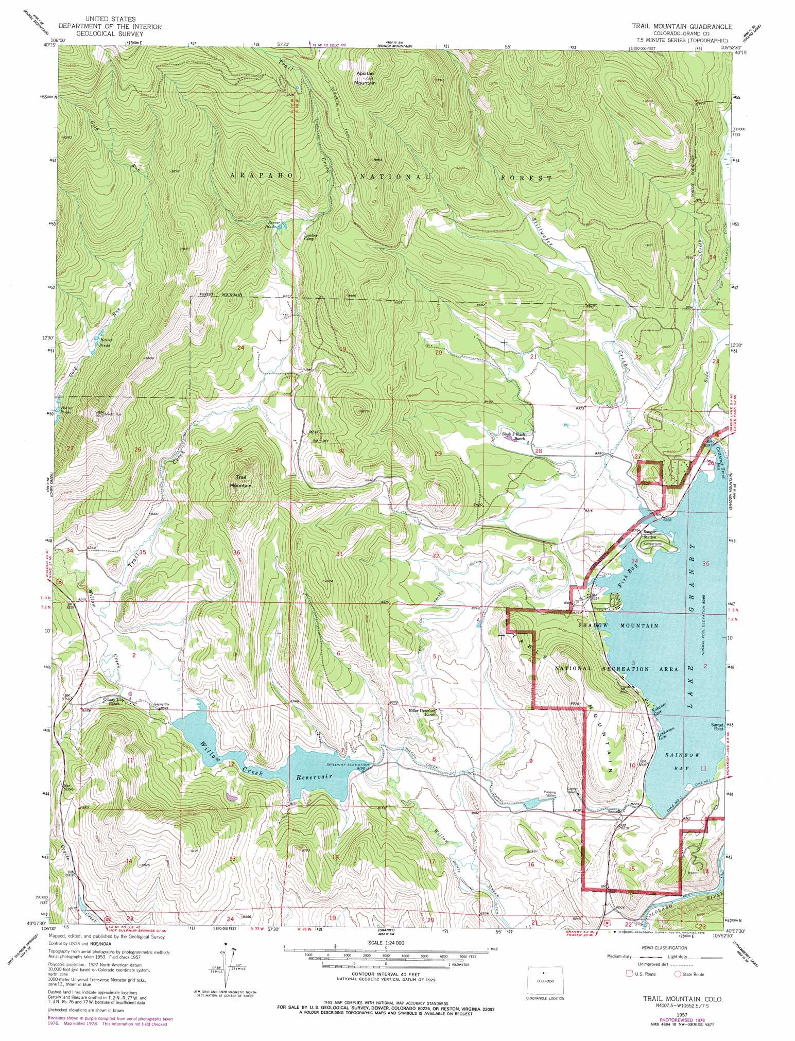
USGS Topo Quad 40105b8 - 1:24,000 scale
| Topo Map Name: | Trail Mountain |
| USGS Topo Quad ID: | 40105b8 |
| Print Size: | ca. 21 1/4" wide x 27" high |
| Southeast Coordinates: | 40.125° N latitude / 105.875° W longitude |
| Map Center Coordinates: | 40.1875° N latitude / 105.9375° W longitude |
| U.S. State: | CO |
| Filename: | o40105b8.jpg |
| Download Map JPG Image: | Trail Mountain topo map 1:24,000 scale |
| Map Type: | Topographic |
| Topo Series: | 7.5´ |
| Map Scale: | 1:24,000 |
| Source of Map Images: | United States Geological Survey (USGS) |
| Alternate Map Versions: |
Trail Mountain CO 1957, updated 1959 Download PDF Buy paper map Trail Mountain CO 1957, updated 1962 Download PDF Buy paper map Trail Mountain CO 1957, updated 1963 Download PDF Buy paper map Trail Mountain CO 1957, updated 1963 Download PDF Buy paper map Trail Mountain CO 1957, updated 1978 Download PDF Buy paper map Trail Mountain CO 2011 Download PDF Buy paper map Trail Mountain CO 2013 Download PDF Buy paper map Trail Mountain CO 2016 Download PDF Buy paper map |
| FStopo: | US Forest Service topo Trail Mountain is available: Download FStopo PDF Download FStopo TIF |
1:24,000 Topo Quads surrounding Trail Mountain
Rand |
Jack Creek Ranch |
Mount Richthofen |
Fall River Pass |
Trail Ridge |
Parkview Mountain |
Radial Mountain |
Bowen Mountain |
Grand Lake |
Mchenrys Peak |
Corral Peaks |
Cabin Creek |
Trail Mountain |
Shadow Mountain |
Isolation Peak |
Parshall |
Hot Sulpher Springs |
Granby |
Strawberry Lake |
Monarch Lake |
Battle Mountain |
Sylvan Reservoir |
Bottle Pass |
Fraser |
East Portal |
> Back to 40105a1 at 1:100,000 scale
> Back to 40104a1 at 1:250,000 scale
> Back to U.S. Topo Maps home
Trail Mountain topo map: Gazetteer
Trail Mountain: Bays
Cutthroat Trout Bay elevation 2525m 8284′Fish Bay elevation 2525m 8284′
Kokanee Cove elevation 2525m 8284′
Lochleven Cove elevation 2525m 8284′
Rainbow Bay elevation 2525m 8284′
Trail Mountain: Canals
Red Top Valley Ditch elevation 2568m 8425′Willow Creek Pump Canal elevation 2465m 8087′
Trail Mountain: Dams
Bunte Dam elevation 2512m 8241′Granby Dikes Number 1, 2, and 4 Dam elevation 2511m 8238′
Willow Creek Dam elevation 2479m 8133′
Trail Mountain: Reservoirs
Bunte Reservoir elevation 2512m 8241′Willow Creek Reservoir elevation 2479m 8133′
Trail Mountain: Springs
Soda Spring elevation 2538m 8326′Trail Mountain: Streams
Soda Creek elevation 2525m 8284′Stillwater Creek elevation 2525m 8284′
Trail Creek elevation 2500m 8202′
Trail Mountain: Summits
Apiatan Mountain elevation 3139m 10298′Table Mountain elevation 2688m 8818′
Trail Mountain elevation 2857m 9373′
Trail Mountain digital topo map on disk
Buy this Trail Mountain topo map showing relief, roads, GPS coordinates and other geographical features, as a high-resolution digital map file on DVD: