Jack Creek Ranch Topo Map Colorado
To zoom in, hover over the map of Jack Creek Ranch
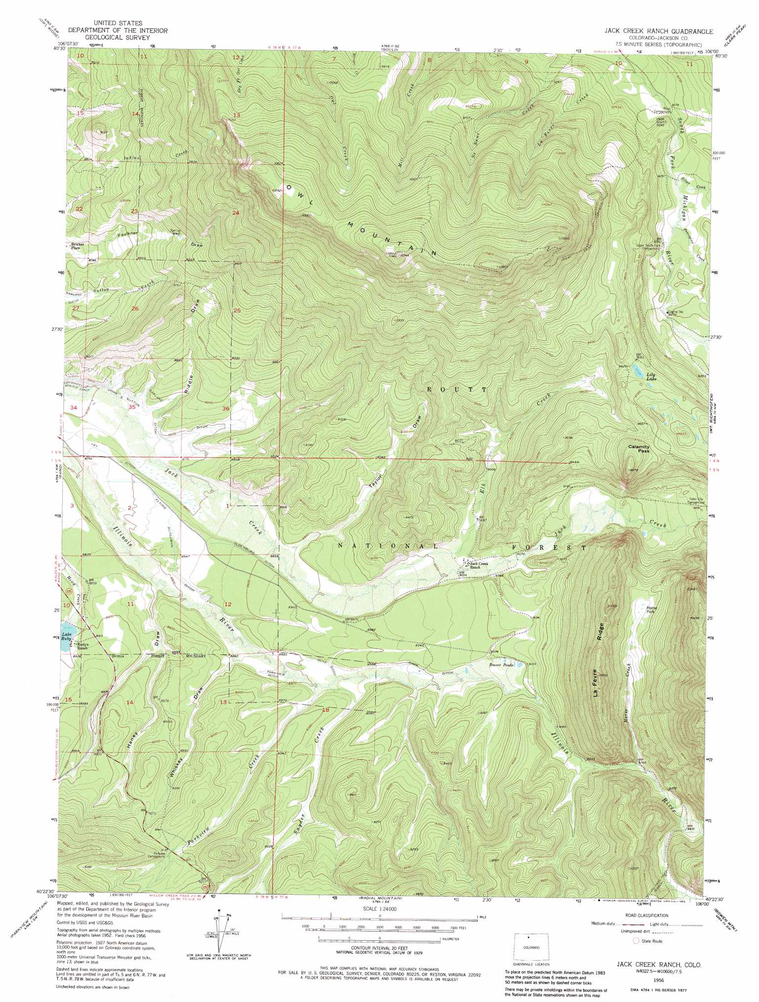
USGS Topo Quad 40106d1 - 1:24,000 scale
| Topo Map Name: | Jack Creek Ranch |
| USGS Topo Quad ID: | 40106d1 |
| Print Size: | ca. 21 1/4" wide x 27" high |
| Southeast Coordinates: | 40.375° N latitude / 106° W longitude |
| Map Center Coordinates: | 40.4375° N latitude / 106.0625° W longitude |
| U.S. State: | CO |
| Filename: | o40106d1.jpg |
| Download Map JPG Image: | Jack Creek Ranch topo map 1:24,000 scale |
| Map Type: | Topographic |
| Topo Series: | 7.5´ |
| Map Scale: | 1:24,000 |
| Source of Map Images: | United States Geological Survey (USGS) |
| Alternate Map Versions: |
Jack Creek Ranch CO 1956, updated 1958 Download PDF Buy paper map Jack Creek Ranch CO 1956, updated 1958 Download PDF Buy paper map Jack Creek Ranch CO 1956, updated 1963 Download PDF Buy paper map Jack Creek Ranch CO 1956, updated 1963 Download PDF Buy paper map Jack Creek Ranch CO 1956, updated 1973 Download PDF Buy paper map Jack Creek Ranch CO 1956, updated 1983 Download PDF Buy paper map Jack Creek Ranch CO 2000, updated 2004 Download PDF Buy paper map Jack Creek Ranch CO 2011 Download PDF Buy paper map Jack Creek Ranch CO 2013 Download PDF Buy paper map Jack Creek Ranch CO 2016 Download PDF Buy paper map |
| FStopo: | US Forest Service topo Jack Creek Ranch is available: Download FStopo PDF Download FStopo TIF |
1:24,000 Topo Quads surrounding Jack Creek Ranch
Walden |
Gould Nw |
Johnny Moore Mountain |
Rawah Lakes |
Boston Peak |
Macfarlane Reservoir |
Owl Ridge |
Gould |
Clark Peak |
Chambers Lake |
Buffalo Peak |
Rand |
Jack Creek Ranch |
Mount Richthofen |
Fall River Pass |
Hyannis Peak |
Parkview Mountain |
Radial Mountain |
Bowen Mountain |
Grand Lake |
Gunsight Pass |
Corral Peaks |
Cabin Creek |
Trail Mountain |
Shadow Mountain |
> Back to 40106a1 at 1:100,000 scale
> Back to 40106a1 at 1:250,000 scale
> Back to U.S. Topo Maps home
Jack Creek Ranch topo map: Gazetteer
Jack Creek Ranch: Canals
Flying Dutchman Ditch elevation 2693m 8835′Garland Ditch elevation 2671m 8763′
Jay Ditch elevation 2684m 8805′
Oldenburg Ditch elevation 2708m 8884′
Olive Ditch elevation 2720m 8923′
Park Ditch elevation 2745m 9005′
Parkview Ditch elevation 2711m 8894′
Jack Creek Ranch: Dams
Cattail Number 1 Dam elevation 2905m 9530′Cattail Pond Dam elevation 2817m 9242′
Donath Lake Dam elevation 3125m 10252′
Fairport Dam elevation 3143m 10311′
Horseshoe Number 2 Dam elevation 2826m 9271′
Lake Loveland Dam elevation 2739m 8986′
Lake Roslyn Dam elevation 2706m 8877′
Rist-Benson Dam elevation 2731m 8959′
Jack Creek Ranch: Flats
Horse Park elevation 2919m 9576′Jack Creek Ranch: Gaps
Calamity Pass elevation 2956m 9698′Jack Creek Ranch: Lakes
Lily Lake elevation 2943m 9655′Jack Creek Ranch: Reservoirs
Cattail Reservoir elevation 2817m 9242′Cattail Reservoir Number 1 elevation 2905m 9530′
Donath Lake elevation 3125m 10252′
Fairport Reservoir elevation 3143m 10311′
Lake Loveland elevation 2739m 8986′
Lake Roslyn elevation 2706m 8877′
Lake Ruby elevation 2709m 8887′
South Side Reservoir elevation 2731m 8959′
Jack Creek Ranch: Ridges
La Fevre Ridge elevation 3089m 10134′Jack Creek Ranch: Streams
Elk Creek elevation 2728m 8950′Horse Creek elevation 2832m 9291′
La Fevre Creek elevation 2770m 9087′
Parkview Creek elevation 2715m 8907′
Porcupine Creek elevation 2817m 9242′
Silver Creek elevation 2812m 9225′
Snyder Creek elevation 2717m 8914′
Jack Creek Ranch: Summits
Owl Mountain elevation 3338m 10951′Jack Creek Ranch: Valleys
Haney Draw elevation 2680m 8792′Riddle Draw elevation 2665m 8743′
Taylor Draw elevation 2707m 8881′
Whiskey Draw elevation 2703m 8868′
Jack Creek Ranch digital topo map on disk
Buy this Jack Creek Ranch topo map showing relief, roads, GPS coordinates and other geographical features, as a high-resolution digital map file on DVD: