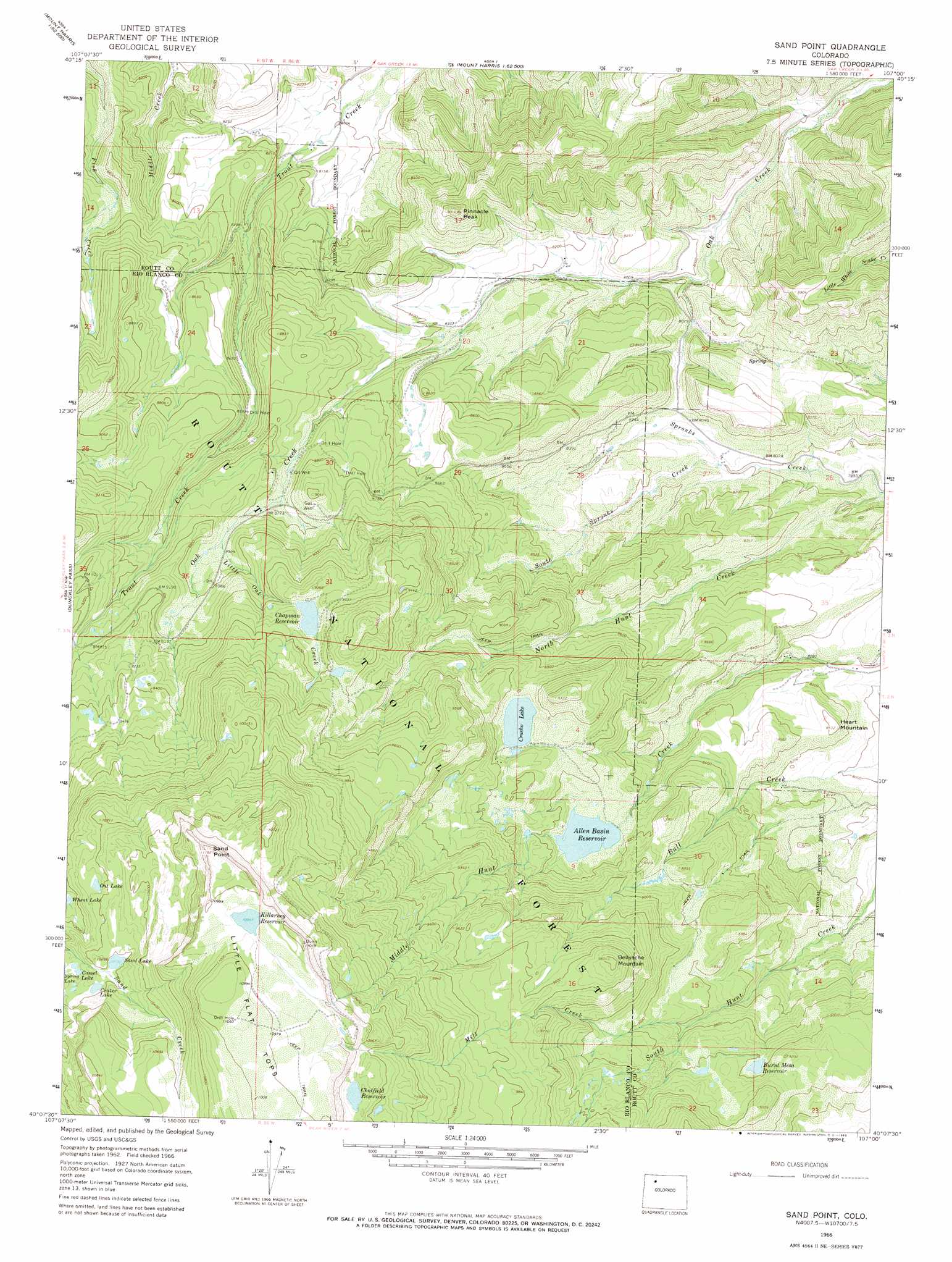
Sand Point Topo Map Colorado
To zoom in, hover over the map of Sand Point
USGS Topo Quad 40107b1 - 1:24,000 scale
| Topo Map Name: | Sand Point |
| USGS Topo Quad ID: | 40107b1 |
| Print Size: | ca. 21 1/4" wide x 27" high |
| Southeast Coordinates: | 40.125° N latitude / 107° W longitude |
| Map Center Coordinates: | 40.1875° N latitude / 107.0625° W longitude |
| U.S. State: | CO |
| Filename: | o40107b1.jpg |
| Download Map JPG Image: | Sand Point topo map 1:24,000 scale |
| Map Type: | Topographic |
| Topo Series: | 7.5´ |
| Map Scale: | 1:24,000 |
| Source of Map Images: | United States Geological Survey (USGS) |
| Alternate Map Versions: |
Sand Point CO 1966, updated 1969 Download PDF Buy paper map Sand Point CO 1966, updated 1969 Download PDF Buy paper map Sand Point CO 1966, updated 1977 Download PDF Buy paper map Sand Point CO 2000, updated 2004 Download PDF Buy paper map Sand Point CO 2011 Download PDF Buy paper map Sand Point CO 2013 Download PDF Buy paper map Sand Point CO 2016 Download PDF Buy paper map |
| FStopo: | US Forest Service topo Sand Point is available: Download FStopo PDF Download FStopo TIF |
1:24,000 Topo Quads surrounding Sand Point
Hayden |
Mount Harris |
Milner |
Cow Creek |
Steamboat Springs |
Hayden Gulch |
Dunckley |
Rattlesnake Butte |
Oak Creek |
Blacktail Mountain |
Pagoda Peak |
Dunckley Pass |
Sand Point |
Yampa |
Green Ridge |
Ripple Creek |
Devils Causeway |
Orno Peak |
Trapper |
Toponas |
Big Marvine Peak |
Trappers Lake |
Dome Peak |
Burns North |
Blue Hill |
> Back to 40107a1 at 1:100,000 scale
> Back to 40106a1 at 1:250,000 scale
> Back to U.S. Topo Maps home
Sand Point topo map: Gazetteer
Sand Point: Cliffs
Sand Point elevation 3404m 11167′Sand Point: Dams
Allen Basin Dam elevation 2652m 8700′Burnt Mesa Dam elevation 2737m 8979′
Chapman Dam elevation 2824m 9265′
Simon Number 1 Dam elevation 2713m 8900′
Sand Point: Lakes
Camel Lake elevation 3071m 10075′Crater Lake elevation 3097m 10160′
Crosho Lake elevation 2713m 8900′
Oat Lake elevation 3094m 10150′
Sand Lake elevation 3108m 10196′
Sand Point: Reservoirs
Allen Basin Reservoir elevation 2652m 8700′Burnt Mesa Reservoir elevation 2737m 8979′
Chapman Reservoir elevation 2824m 9265′
Chatfield Reservoir elevation 3191m 10469′
Killarney Reservoir elevation 3339m 10954′
Simon Reservoir Number 1 elevation 2713m 8900′
Sand Point: Streams
Allen Basin District Ditch elevation 2617m 8585′Allen Basin Fill Ditch elevation 2653m 8704′
Burnt Mesa Filler Ditch elevation 2736m 8976′
Crosho Inlet Rossi Bypass elevation 2701m 8861′
Crosho Outlet Ditch elevation 2549m 8362′
Last Chance Ditch elevation 2571m 8435′
Little Oak Creek elevation 2704m 8871′
Mill Creek elevation 2671m 8763′
Mill Creek Ditch elevation 2568m 8425′
Rich Ditch elevation 2643m 8671′
South Spronks Creek elevation 2464m 8083′
Spronks Creek elevation 2393m 7851′
Trout Creek Ditch elevation 2441m 8008′
Trout Creek School Ditch elevation 2450m 8038′
Sand Point: Summits
Bellyache Mountain elevation 2991m 9812′Heart Mountain elevation 2567m 8421′
Pinnacle Peak elevation 2747m 9012′
Sand Point digital topo map on disk
Buy this Sand Point topo map showing relief, roads, GPS coordinates and other geographical features, as a high-resolution digital map file on DVD: