White Lake Topo Map New York
To zoom in, hover over the map of White Lake
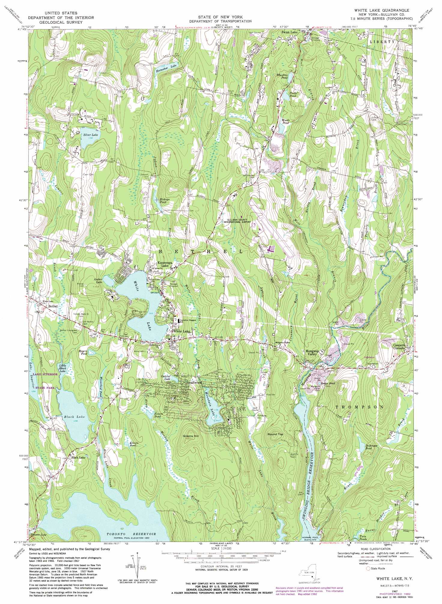
USGS Topo Quad 41074f7 - 1:24,000 scale
| Topo Map Name: | White Lake |
| USGS Topo Quad ID: | 41074f7 |
| Print Size: | ca. 21 1/4" wide x 27" high |
| Southeast Coordinates: | 41.625° N latitude / 74.75° W longitude |
| Map Center Coordinates: | 41.6875° N latitude / 74.8125° W longitude |
| U.S. State: | NY |
| Filename: | o41074f7.jpg |
| Download Map JPG Image: | White Lake topo map 1:24,000 scale |
| Map Type: | Topographic |
| Topo Series: | 7.5´ |
| Map Scale: | 1:24,000 |
| Source of Map Images: | United States Geological Survey (USGS) |
| Alternate Map Versions: |
White Lake NY 1967, updated 1969 Download PDF Buy paper map White Lake NY 1967, updated 1982 Download PDF Buy paper map White Lake NY 2010 Download PDF Buy paper map White Lake NY 2013 Download PDF Buy paper map White Lake NY 2016 Download PDF Buy paper map |
1:24,000 Topo Quads surrounding White Lake
Horton |
Roscoe |
Livingston Manor |
Willowemoc |
Claryville |
Callicoon |
Jeffersonville |
Liberty West |
Liberty East |
Grahamsville |
Damascus |
Lake Huntington |
White Lake |
Monticello |
Woodridge |
Narrowsburg |
Eldred |
Highland Lake |
Hartwood |
Yankee Lake |
Rowland |
Shohola |
Pond Eddy |
Port Jervis North |
Otisville |
> Back to 41074e1 at 1:100,000 scale
> Back to 41074a1 at 1:250,000 scale
> Back to U.S. Topo Maps home
White Lake topo map: Gazetteer
White Lake: Airports
Firemans White Lake Seaplane Base elevation 408m 1338′Hilltop Heliport elevation 423m 1387′
Sullivan County International Airport elevation 417m 1368′
White Lake: Lakes
Amber Lake elevation 403m 1322′Black Lake elevation 382m 1253′
Dodge Pond elevation 332m 1089′
Gabriel Lake elevation 387m 1269′
Horseshoe Lake elevation 411m 1348′
Kilcoin Pond elevation 383m 1256′
Little Black Lake elevation 382m 1253′
Meyers Pond elevation 394m 1292′
Sicans Pond elevation 382m 1253′
Silver Lake elevation 423m 1387′
White Lake elevation 403m 1322′
Woods Pond elevation 363m 1190′
White Lake: Populated Places
Bethel elevation 404m 1325′Black Lake elevation 407m 1335′
Coopers Corners elevation 379m 1243′
Kauneonga Lake elevation 411m 1348′
Mongaup Valley elevation 339m 1112′
Smallwood elevation 366m 1200′
White Lake elevation 407m 1335′
White Lake: Reservoirs
Bishops Pond elevation 393m 1289′Delfongos Pond elevation 355m 1164′
Mountain Lake elevation 364m 1194′
Pauls Pond elevation 372m 1220′
Wesserlauf Pond elevation 392m 1286′
Wheelers Pond elevation 384m 1259′
Zieglers Pond elevation 425m 1394′
White Lake: Streams
Beaverdam Brook elevation 339m 1112′Creamery Brook elevation 326m 1069′
Frasers Brook elevation 336m 1102′
Hardin Brook elevation 344m 1128′
Judson Brook elevation 370m 1213′
Kinne Brook elevation 326m 1069′
Lemons Brook elevation 383m 1256′
Lybolt Brook elevation 342m 1122′
West Branch Mongaup River elevation 329m 1079′
White Lake: Summits
Greens Hill elevation 435m 1427′Round Top elevation 410m 1345′
White Lake digital topo map on disk
Buy this White Lake topo map showing relief, roads, GPS coordinates and other geographical features, as a high-resolution digital map file on DVD:
New York, Vermont, Connecticut & Western Massachusetts
Buy digital topo maps: New York, Vermont, Connecticut & Western Massachusetts