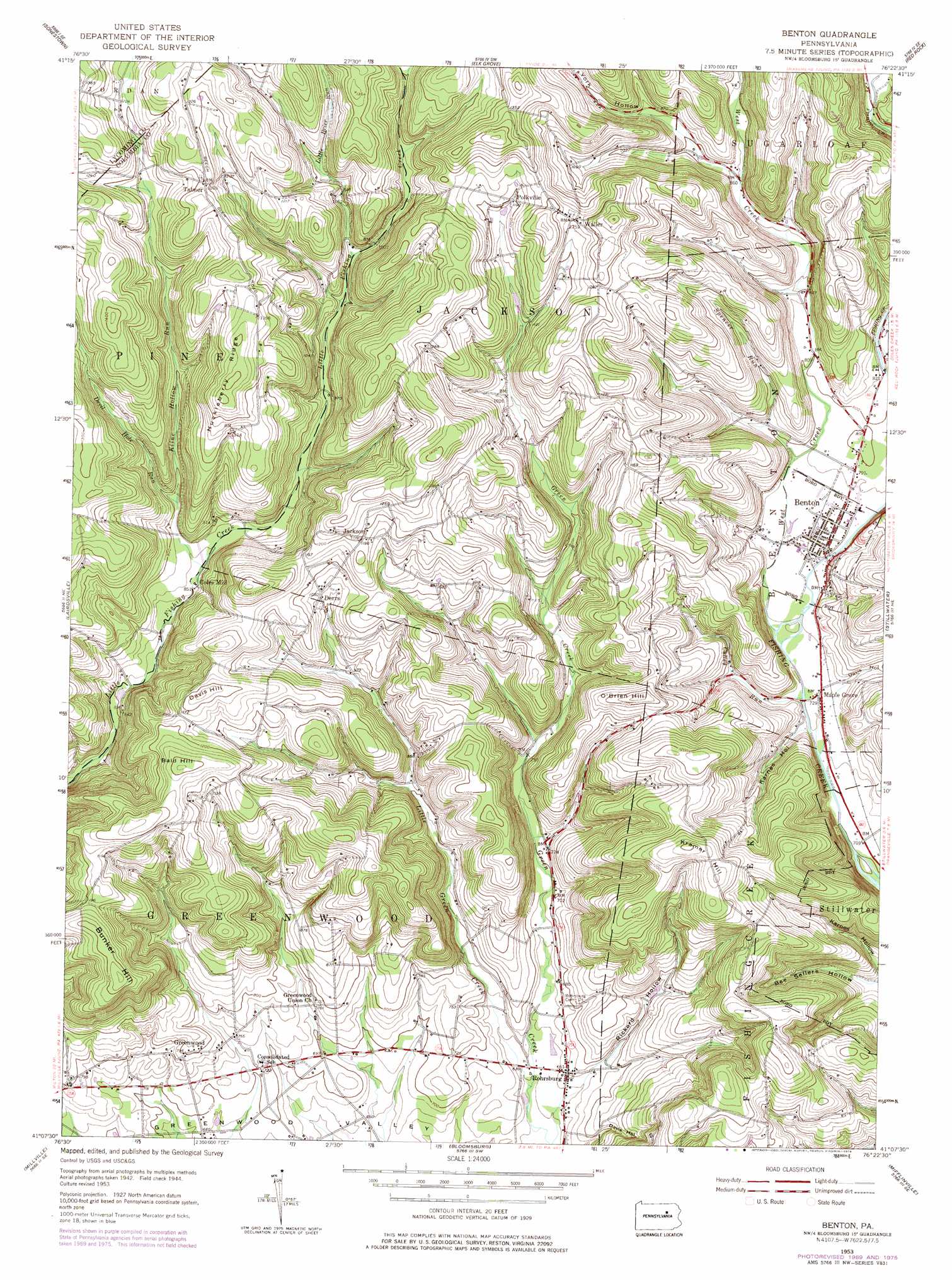
Benton Topo Map Pennsylvania
To zoom in, hover over the map of Benton
USGS Topo Quad 41076b4 - 1:24,000 scale
| Topo Map Name: | Benton |
| USGS Topo Quad ID: | 41076b4 |
| Print Size: | ca. 21 1/4" wide x 27" high |
| Southeast Coordinates: | 41.125° N latitude / 76.375° W longitude |
| Map Center Coordinates: | 41.1875° N latitude / 76.4375° W longitude |
| U.S. State: | PA |
| Filename: | o41076b4.jpg |
| Download Map JPG Image: | Benton topo map 1:24,000 scale |
| Map Type: | Topographic |
| Topo Series: | 7.5´ |
| Map Scale: | 1:24,000 |
| Source of Map Images: | United States Geological Survey (USGS) |
| Alternate Map Versions: |
Benton PA 1953, updated 1955 Download PDF Buy paper map Benton PA 1953, updated 1967 Download PDF Buy paper map Benton PA 1953, updated 1971 Download PDF Buy paper map Benton PA 1953, updated 1978 Download PDF Buy paper map Benton PA 1953, updated 1978 Download PDF Buy paper map Benton PA 2010 Download PDF Buy paper map Benton PA 2013 Download PDF Buy paper map Benton PA 2016 Download PDF Buy paper map |
1:24,000 Topo Quads surrounding Benton
Hillsgrove |
Eagles Mere |
Laporte |
Lopez |
Dutch Mountain |
Picture Rocks |
Sonestown |
Elk Grove |
Red Rock |
Sweet Valley |
Hughesville |
Lairdsville |
Benton |
Stillwater |
Shickshinny |
Washingtonville |
Millville |
Bloomsburg |
Mifflinville |
Berwick |
Riverside |
Danville |
Catawissa |
Shumans |
Nuremberg |
> Back to 41076a1 at 1:100,000 scale
> Back to 41076a1 at 1:250,000 scale
> Back to U.S. Topo Maps home
Benton topo map: Gazetteer
Benton: Airports
Benton Airport elevation 234m 767′Benton: Populated Places
Benton elevation 233m 764′Coles Mill elevation 266m 872′
Derrs elevation 319m 1046′
Greenwood elevation 240m 787′
Jackson elevation 363m 1190′
Maple Grove elevation 221m 725′
Polkville elevation 360m 1181′
Rohrsburg elevation 200m 656′
Talmer elevation 400m 1312′
Waller elevation 384m 1259′
Waterville elevation 250m 820′
Benton: Ridges
Huckleberry Ridge elevation 427m 1400′Benton: Streams
Culley Run elevation 221m 725′Devil Hole Run elevation 260m 853′
Kline Hollow Run elevation 265m 869′
Little Brier Run elevation 306m 1003′
Little Green Creek elevation 188m 616′
Spencer Run elevation 236m 774′
West Creek elevation 225m 738′
Benton: Summits
Bald Hill elevation 403m 1322′Bunker Hill elevation 410m 1345′
Davis Hill elevation 379m 1243′
Kramer Hill elevation 398m 1305′
O'Brien Hill elevation 350m 1148′
Benton: Valleys
Davis Hollow elevation 223m 731′Karnes Hollow elevation 221m 725′
Rickard Hollow elevation 194m 636′
Schultz Hollow elevation 283m 928′
York Hollow elevation 262m 859′
Benton digital topo map on disk
Buy this Benton topo map showing relief, roads, GPS coordinates and other geographical features, as a high-resolution digital map file on DVD:
New York, Vermont, Connecticut & Western Massachusetts
Buy digital topo maps: New York, Vermont, Connecticut & Western Massachusetts