Laporte Topo Map Pennsylvania
To zoom in, hover over the map of Laporte
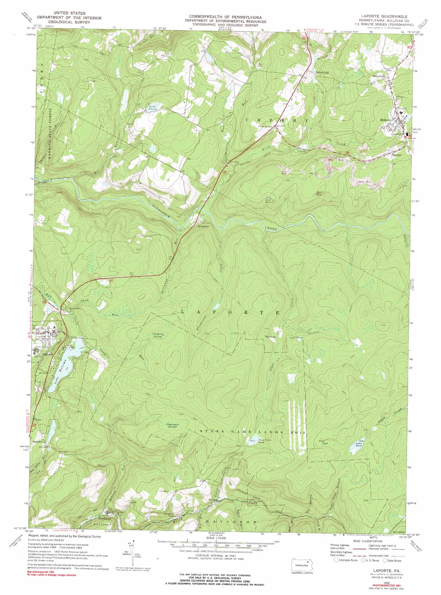
USGS Topo Quad 41076d4 - 1:24,000 scale
| Topo Map Name: | Laporte |
| USGS Topo Quad ID: | 41076d4 |
| Print Size: | ca. 21 1/4" wide x 27" high |
| Southeast Coordinates: | 41.375° N latitude / 76.375° W longitude |
| Map Center Coordinates: | 41.4375° N latitude / 76.4375° W longitude |
| U.S. State: | PA |
| Filename: | o41076d4.jpg |
| Download Map JPG Image: | Laporte topo map 1:24,000 scale |
| Map Type: | Topographic |
| Topo Series: | 7.5´ |
| Map Scale: | 1:24,000 |
| Source of Map Images: | United States Geological Survey (USGS) |
| Alternate Map Versions: |
LaPorte PA 1969, updated 1973 Download PDF Buy paper map LaPorte PA 1969, updated 1977 Download PDF Buy paper map LaPorte PA 1969, updated 1981 Download PDF Buy paper map Laporte PA 2010 Download PDF Buy paper map Laporte PA 2013 Download PDF Buy paper map Laporte PA 2016 Download PDF Buy paper map |
1:24,000 Topo Quads surrounding Laporte
Leroy |
Powell |
Monroeton |
Wyalusing |
Laceyville |
Shunk |
Overton |
Dushore |
Colley |
Jenningsville |
Hillsgrove |
Eagles Mere |
Laporte |
Lopez |
Dutch Mountain |
Picture Rocks |
Sonestown |
Elk Grove |
Red Rock |
Sweet Valley |
Hughesville |
Lairdsville |
Benton |
Stillwater |
Shickshinny |
> Back to 41076a1 at 1:100,000 scale
> Back to 41076a1 at 1:250,000 scale
> Back to U.S. Topo Maps home
Laporte topo map: Gazetteer
Laporte: Dams
Glass Creek Dam elevation 580m 1902′Lake Mokoma Dam elevation 533m 1748′
Sullivan Dam elevation 567m 1860′
Laporte: Falls
Dutchman Falls elevation 461m 1512′Laporte: Lakes
Glass Creek Pond elevation 610m 2001′Lake Akela elevation 580m 1902′
Lopez Pond elevation 677m 2221′
Laporte: Populated Places
Bernice elevation 588m 1929′Foley Corner elevation 567m 1860′
Laporte elevation 597m 1958′
Mildred elevation 558m 1830′
Nordmont elevation 406m 1332′
Ringdale elevation 463m 1519′
Satterfield elevation 567m 1860′
Shinerville elevation 604m 1981′
Thorndale elevation 574m 1883′
Laporte: Rapids
Haystacks Rapids elevation 426m 1397′Laporte: Reservoirs
Glass Creek Pond elevation 580m 1902′Mokoma Lake elevation 531m 1742′
Laporte: Streams
Big Run elevation 467m 1532′Birch Creek elevation 460m 1509′
Conklin Run elevation 531m 1742′
Dutchman Run elevation 450m 1476′
Elklick Run elevation 405m 1328′
Ellis Creek elevation 500m 1640′
Floodwood Creek elevation 466m 1528′
Glass Creek elevation 476m 1561′
Lopez Pond Branch elevation 584m 1916′
Mill Run elevation 423m 1387′
Muncy Creek elevation 693m 2273′
Peters Creek elevation 486m 1594′
Rock Run elevation 548m 1797′
Rock Run elevation 487m 1597′
Sand Run elevation 518m 1699′
South Branch Rock Run elevation 572m 1876′
Tublick Run elevation 496m 1627′
Laporte: Swamps
Cranberry Swamp elevation 612m 2007′Dutchman Swamp elevation 619m 2030′
Laporte: Valleys
Black Hollow elevation 527m 1729′Dry Hollow elevation 561m 1840′
Laporte digital topo map on disk
Buy this Laporte topo map showing relief, roads, GPS coordinates and other geographical features, as a high-resolution digital map file on DVD:
New York, Vermont, Connecticut & Western Massachusetts
Buy digital topo maps: New York, Vermont, Connecticut & Western Massachusetts