Sweet Valley Topo Map Pennsylvania
To zoom in, hover over the map of Sweet Valley
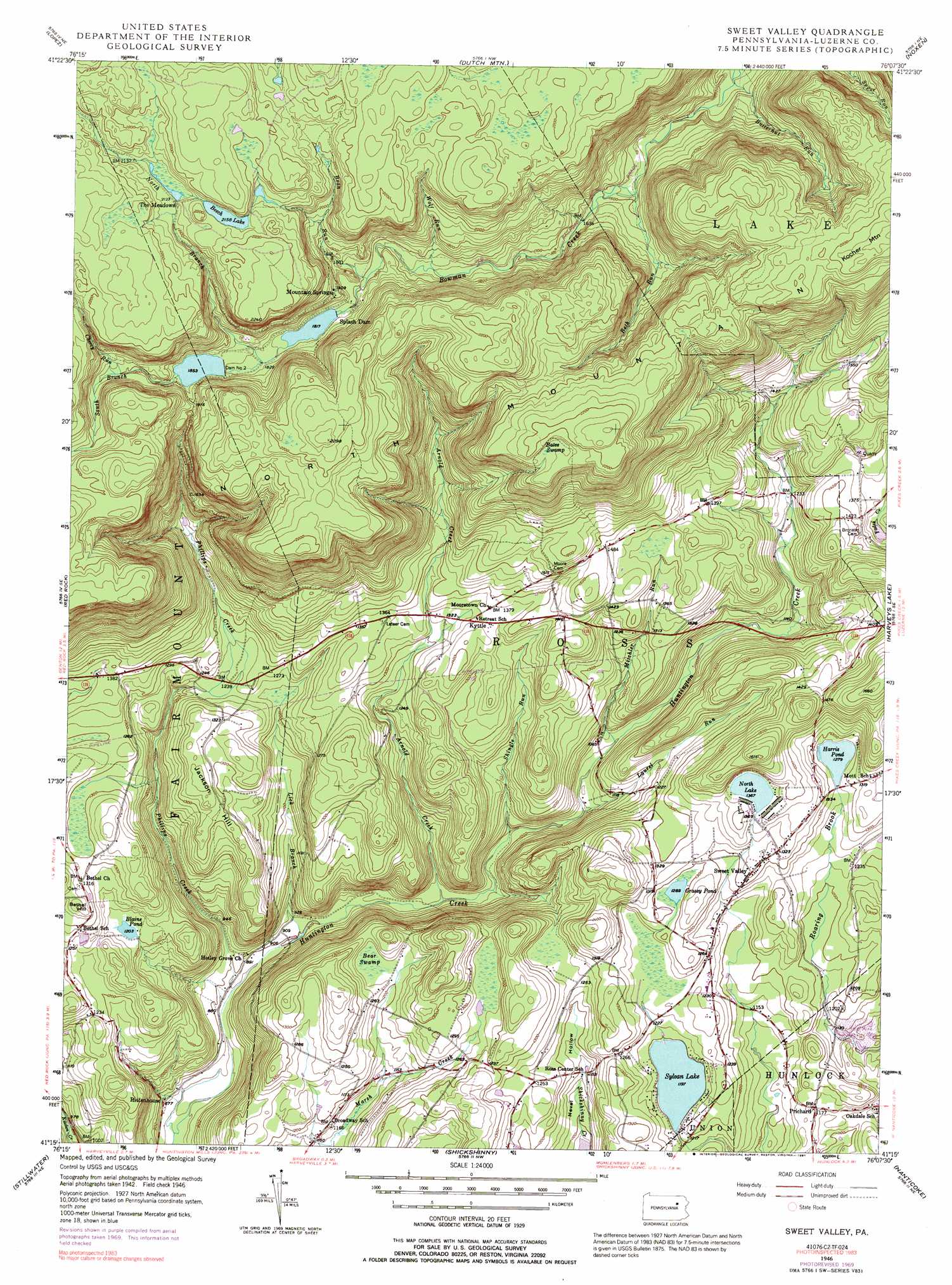
USGS Topo Quad 41076c2 - 1:24,000 scale
| Topo Map Name: | Sweet Valley |
| USGS Topo Quad ID: | 41076c2 |
| Print Size: | ca. 21 1/4" wide x 27" high |
| Southeast Coordinates: | 41.25° N latitude / 76.125° W longitude |
| Map Center Coordinates: | 41.3125° N latitude / 76.1875° W longitude |
| U.S. State: | PA |
| Filename: | o41076c2.jpg |
| Download Map JPG Image: | Sweet Valley topo map 1:24,000 scale |
| Map Type: | Topographic |
| Topo Series: | 7.5´ |
| Map Scale: | 1:24,000 |
| Source of Map Images: | United States Geological Survey (USGS) |
| Alternate Map Versions: |
Sweet Valley PA 1946, updated 1964 Download PDF Buy paper map Sweet Valley PA 1946, updated 1971 Download PDF Buy paper map Sweet Valley PA 1946, updated 1979 Download PDF Buy paper map Sweet Valley PA 1946, updated 1991 Download PDF Buy paper map Sweet Valley PA 1949 Download PDF Buy paper map Sweet Valley PA 1949 Download PDF Buy paper map Sweet Valley PA 2010 Download PDF Buy paper map Sweet Valley PA 2013 Download PDF Buy paper map Sweet Valley PA 2016 Download PDF Buy paper map |
1:24,000 Topo Quads surrounding Sweet Valley
Dushore |
Colley |
Jenningsville |
Meshoppen |
Tunkhannock |
Laporte |
Lopez |
Dutch Mountain |
Noxen |
Center Moreland |
Elk Grove |
Red Rock |
Sweet Valley |
Harveys Lake |
Kingston |
Benton |
Stillwater |
Shickshinny |
Nanticoke |
Wilkes-Barre West |
Bloomsburg |
Mifflinville |
Berwick |
Sybertsville |
Freeland |
> Back to 41076a1 at 1:100,000 scale
> Back to 41076a1 at 1:250,000 scale
> Back to U.S. Topo Maps home
Sweet Valley topo map: Gazetteer
Sweet Valley: Airports
Morris Airport elevation 395m 1295′Sweet Valley: Dams
Dam Number Two elevation 561m 1840′Harris Pond Dam elevation 395m 1295′
Mount Spring Dam elevation 676m 2217′
Splash Dam elevation 550m 1804′
Sweet Valley: Lakes
Beech Lake elevation 653m 2142′Blaine Pond elevation 366m 1200′
Grassy Pond elevation 391m 1282′
North Lake elevation 415m 1361′
Sylvan Lake elevation 363m 1190′
Sweet Valley: Parks
State Game Lands Number 206 elevation 377m 1236′Sweet Valley: Populated Places
Kyttle elevation 411m 1348′Prichard elevation 356m 1167′
Ripple elevation 421m 1381′
Ripple (historical) elevation 387m 1269′
Rittenhouse elevation 275m 902′
Sweet Valley elevation 404m 1325′
Weintz elevation 413m 1354′
Sweet Valley: Reservoirs
Harris Pond elevation 387m 1269′Mount Spring Lake elevation 561m 1840′
Sweet Valley: Streams
Arnold Creek elevation 285m 935′Bean Run elevation 552m 1811′
Beth Run elevation 487m 1597′
Butternut Run elevation 440m 1443′
Cherry Run elevation 579m 1899′
Laurel Run elevation 318m 1043′
Lick Branch elevation 274m 898′
Mitchler Run elevation 332m 1089′
North Branch Bowman Creek elevation 560m 1837′
Phillips Creek elevation 267m 875′
Shingle Run elevation 298m 977′
South Branch Bowman Creek elevation 560m 1837′
Wolf Run elevation 529m 1735′
Sweet Valley: Summits
Bethel Hill elevation 422m 1384′Jackson Hill elevation 417m 1368′
North Mountain elevation 693m 2273′
Sweet Valley: Swamps
Bates Swamp elevation 650m 2132′Bear Swamp elevation 368m 1207′
Sweet Valley digital topo map on disk
Buy this Sweet Valley topo map showing relief, roads, GPS coordinates and other geographical features, as a high-resolution digital map file on DVD:
New York, Vermont, Connecticut & Western Massachusetts
Buy digital topo maps: New York, Vermont, Connecticut & Western Massachusetts