Cleveland North Topo Map Ohio
To zoom in, hover over the map of Cleveland North
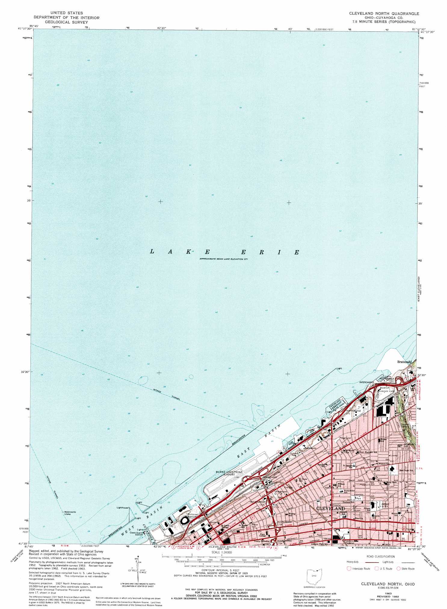
USGS Topo Quad 41081e6 - 1:24,000 scale
| Topo Map Name: | Cleveland North |
| USGS Topo Quad ID: | 41081e6 |
| Print Size: | ca. 21 1/4" wide x 27" high |
| Southeast Coordinates: | 41.5° N latitude / 81.625° W longitude |
| Map Center Coordinates: | 41.5625° N latitude / 81.6875° W longitude |
| U.S. State: | OH |
| Filename: | o41081e6.jpg |
| Download Map JPG Image: | Cleveland North topo map 1:24,000 scale |
| Map Type: | Topographic |
| Topo Series: | 7.5´ |
| Map Scale: | 1:24,000 |
| Source of Map Images: | United States Geological Survey (USGS) |
| Alternate Map Versions: |
Cleveland North OH 1953, updated 1955 Download PDF Buy paper map Cleveland North OH 1963, updated 1965 Download PDF Buy paper map Cleveland North OH 1963, updated 1971 Download PDF Buy paper map Cleveland North OH 1963, updated 1992 Download PDF Buy paper map Cleveland North OH 1994, updated 1997 Download PDF Buy paper map Cleveland North OH 2010 Download PDF Buy paper map Cleveland North OH 2013 Download PDF Buy paper map Cleveland North OH 2016 Download PDF Buy paper map |
1:24,000 Topo Quads surrounding Cleveland North
Eastlake |
||||
Cleveland North |
East Cleveland |
Mayfield Heights |
||
North Olmsted |
Lakewood |
Cleveland South |
Shaker Heights |
Chagrin Falls |
West View |
Berea |
Broadview Heights |
Northfield |
Twinsburg |
> Back to 41081e1 at 1:100,000 scale
> Back to 41080a1 at 1:250,000 scale
> Back to U.S. Topo Maps home
Cleveland North topo map: Gazetteer
Cleveland North: Airports
Burke Lakefront Airport elevation 177m 580′Cleveland North: Basins
East Basin elevation 174m 570′West Basin elevation 174m 570′
Cleveland North: Crossings
Interchange 173A elevation 198m 649′Interchange 173B elevation 193m 633′
Interchange 173C elevation 188m 616′
Interchange 174A elevation 181m 593′
Interchange 174B elevation 177m 580′
Interchange 175 elevation 177m 580′
Interchange 176 elevation 181m 593′
Interchange 177 elevation 180m 590′
Cleveland North: Harbors
Cleveland Harbor elevation 174m 570′Cleveland North: Parks
Cleveland Aquarium (historical) elevation 189m 620′Cleveland Browns Stadium elevation 181m 593′
Cleveland Lakefront State Park elevation 174m 570′
Cleveland Municipal Stadium (historical) elevation 181m 593′
Clinton Park (historical) elevation 192m 629′
Cultural Gardens elevation 179m 587′
Donald Gray Garden elevation 179m 587′
Erieview Plaza elevation 195m 639′
Fort Huntington Park elevation 196m 643′
Gordon Park elevation 188m 616′
Kirtland Park elevation 178m 583′
League Park elevation 197m 646′
Saint Clair Recreation Center elevation 190m 623′
Sterling Park elevation 193m 633′
Superior Avenue Historic District elevation 195m 639′
The Mall elevation 198m 649′
Willard Park elevation 195m 639′
Cleveland North: Populated Places
Bratenahl elevation 187m 613′Hough elevation 198m 649′
Josephatowa elevation 192m 629′
New Chinatown elevation 193m 633′
Old Chinatown elevation 194m 636′
Poznan elevation 193m 633′
Cleveland North: Streams
Cuyahoga River elevation 174m 570′Doan Brook elevation 174m 570′
Cleveland North digital topo map on disk
Buy this Cleveland North topo map showing relief, roads, GPS coordinates and other geographical features, as a high-resolution digital map file on DVD:
 map DVD")