Mayfield Heights Topo Map Ohio
To zoom in, hover over the map of Mayfield Heights
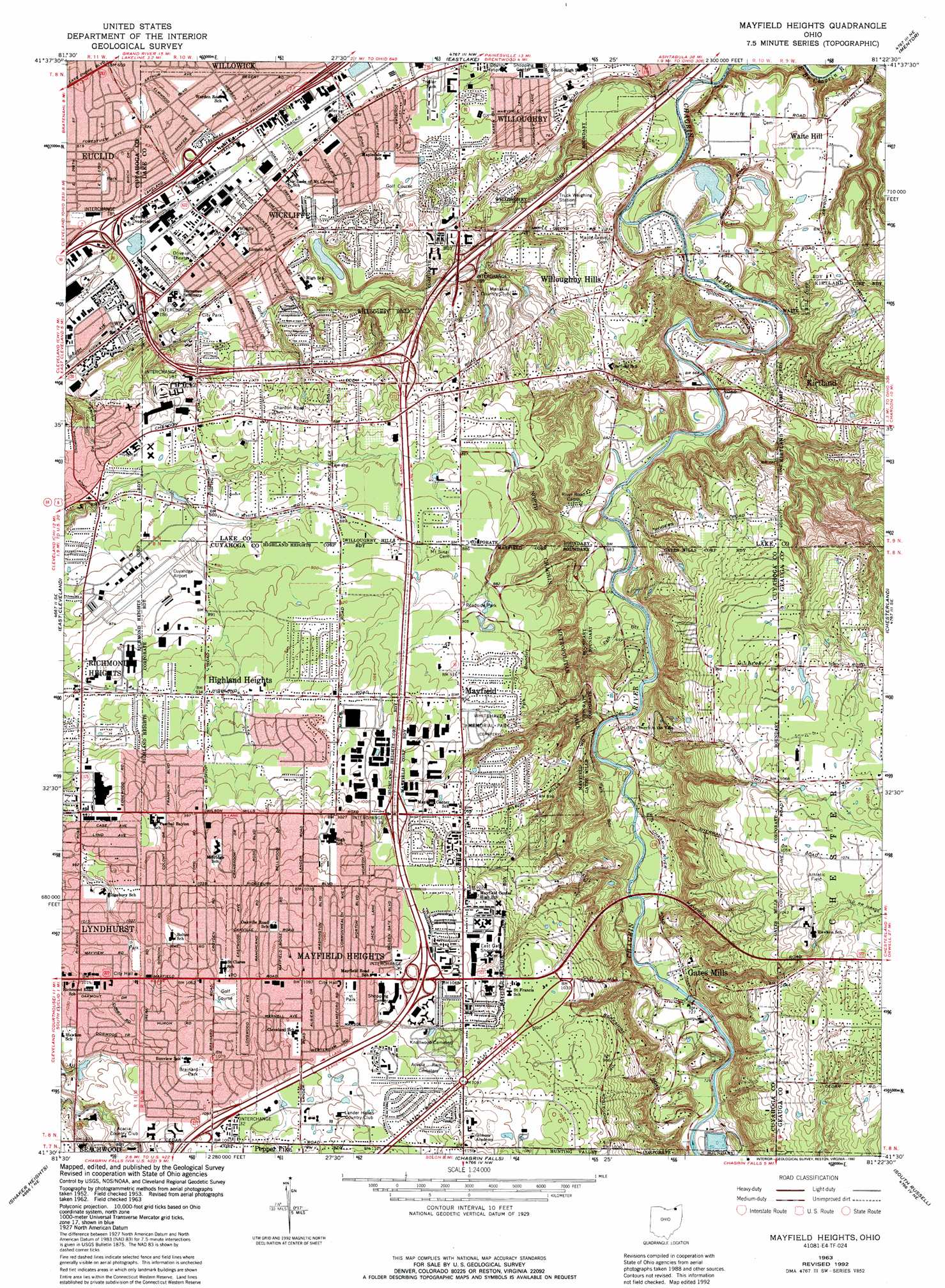
USGS Topo Quad 41081e4 - 1:24,000 scale
| Topo Map Name: | Mayfield Heights |
| USGS Topo Quad ID: | 41081e4 |
| Print Size: | ca. 21 1/4" wide x 27" high |
| Southeast Coordinates: | 41.5° N latitude / 81.375° W longitude |
| Map Center Coordinates: | 41.5625° N latitude / 81.4375° W longitude |
| U.S. State: | OH |
| Filename: | o41081e4.jpg |
| Download Map JPG Image: | Mayfield Heights topo map 1:24,000 scale |
| Map Type: | Topographic |
| Topo Series: | 7.5´ |
| Map Scale: | 1:24,000 |
| Source of Map Images: | United States Geological Survey (USGS) |
| Alternate Map Versions: |
Mayfield Heights OH 1953, updated 1955 Download PDF Buy paper map Mayfield Heights OH 1953, updated 1955 Download PDF Buy paper map Mayfield Heights OH 1963, updated 1964 Download PDF Buy paper map Mayfield Heights OH 1963, updated 1969 Download PDF Buy paper map Mayfield Heights OH 1963, updated 1971 Download PDF Buy paper map Mayfield Heights OH 1963, updated 1980 Download PDF Buy paper map Mayfield Heights OH 1963, updated 1984 Download PDF Buy paper map Mayfield Heights OH 1963, updated 1992 Download PDF Buy paper map Mayfield Heights OH 1994, updated 1997 Download PDF Buy paper map Mayfield Heights OH 2010 Download PDF Buy paper map Mayfield Heights OH 2013 Download PDF Buy paper map Mayfield Heights OH 2016 Download PDF Buy paper map |
1:24,000 Topo Quads surrounding Mayfield Heights
Perry |
||||
Eastlake |
Mentor |
Painesville |
||
Cleveland North |
East Cleveland |
Mayfield Heights |
Chesterland |
Chardon |
Cleveland South |
Shaker Heights |
Chagrin Falls |
South Russell |
Burton |
Broadview Heights |
Northfield |
Twinsburg |
Aurora |
Mantua |
> Back to 41081e1 at 1:100,000 scale
> Back to 41080a1 at 1:250,000 scale
> Back to U.S. Topo Maps home
Mayfield Heights topo map: Gazetteer
Mayfield Heights: Airports
Cuyahoga County Airport elevation 264m 866′Mayfield Heights: Crossings
Interchange 185 elevation 198m 649′Interchange 186 elevation 212m 695′
Interchange 187 elevation 235m 770′
Interchange 189 elevation 224m 734′
Interchange 32 elevation 329m 1079′
Interchange 35 elevation 326m 1069′
Interchange 36 elevation 304m 997′
Mayfield Heights: Falls
Deans Fall elevation 304m 997′Mayfield Heights: Lakes
Oxbow Lagoon elevation 204m 669′Mayfield Heights: Parks
Brainard Park elevation 330m 1082′Coulby Park elevation 235m 770′
Elizabeth B Blossom Subdivision Historic District elevation 328m 1076′
Featherston Park elevation 213m 698′
Hach-Otis Sanctuary State Nature Preserve elevation 250m 820′
Halle Estates Park elevation 238m 780′
Inthar Park elevation 195m 639′
Jindra Park elevation 193m 633′
Nehls Park elevation 225m 738′
Orlando Park elevation 216m 708′
Roadside Park elevation 276m 905′
Rogers Road Field elevation 206m 675′
Saint Joseph Park elevation 269m 882′
Willow Park elevation 192m 629′
Wilsons Mills Settlement Historic District elevation 213m 698′
Mayfield Heights: Populated Places
Concord Estates elevation 209m 685′Courtyard Mobile Home Park elevation 210m 688′
Gates Mills elevation 219m 718′
Highland Heights elevation 286m 938′
Johnson Mobile Home Park elevation 200m 656′
Lyndhurst elevation 315m 1033′
Mayfield elevation 282m 925′
Mayfield Heights elevation 332m 1089′
Pleasant Valley elevation 202m 662′
Rush Road (historical) elevation 198m 649′
Waite Hill elevation 234m 767′
Wickliffe elevation 234m 767′
Willoughby Hills elevation 245m 803′
Mayfield Heights: Post Offices
Gates Mills Post Office elevation 219m 718′Lyndhurst Post Office (historical) elevation 317m 1040′
Mayfield Post Office (historical) elevation 282m 925′
Wickliffe Post Office elevation 231m 757′
Mayfield Heights: Valleys
Deans Gully elevation 231m 757′Mayfield Heights: Woods
A B Williams Memorial Woods elevation 268m 879′Mayfield Heights digital topo map on disk
Buy this Mayfield Heights topo map showing relief, roads, GPS coordinates and other geographical features, as a high-resolution digital map file on DVD:
 map DVD")