Myers Reservoir Topo Map Wyoming
To zoom in, hover over the map of Myers Reservoir
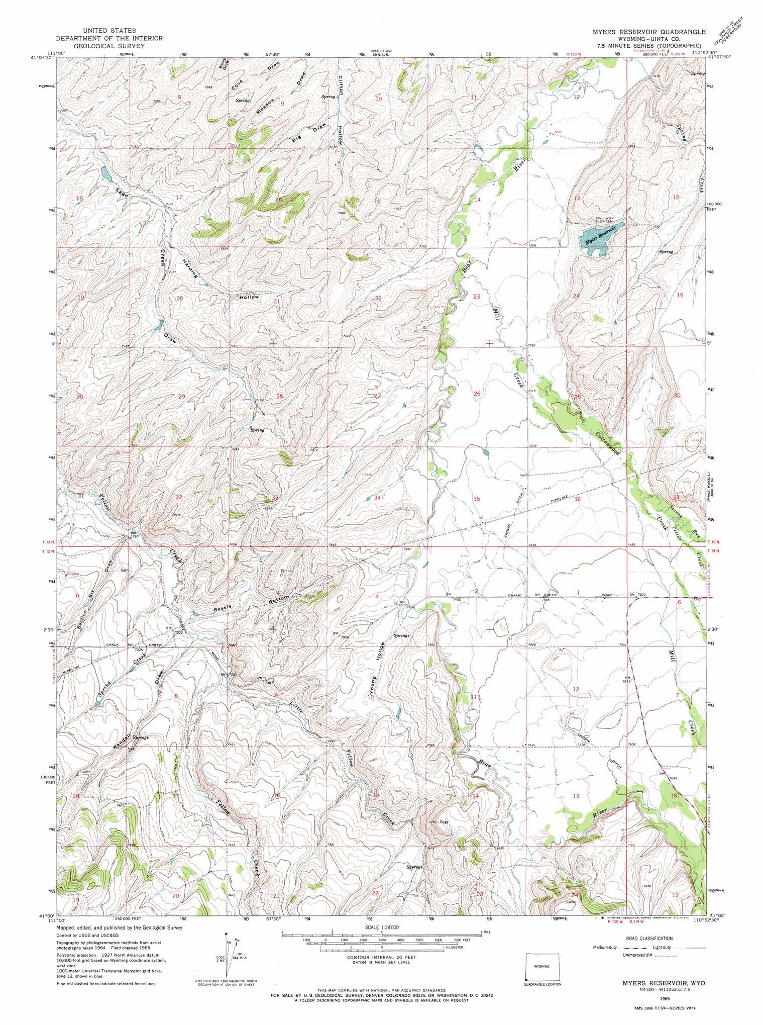
USGS Topo Quad 41110a8 - 1:24,000 scale
| Topo Map Name: | Myers Reservoir |
| USGS Topo Quad ID: | 41110a8 |
| Print Size: | ca. 21 1/4" wide x 27" high |
| Southeast Coordinates: | 41° N latitude / 110.875° W longitude |
| Map Center Coordinates: | 41.0625° N latitude / 110.9375° W longitude |
| U.S. State: | WY |
| Filename: | o41110a8.jpg |
| Download Map JPG Image: | Myers Reservoir topo map 1:24,000 scale |
| Map Type: | Topographic |
| Topo Series: | 7.5´ |
| Map Scale: | 1:24,000 |
| Source of Map Images: | United States Geological Survey (USGS) |
| Alternate Map Versions: |
Myers Reservoir WY 1965, updated 1968 Download PDF Buy paper map Myers Reservoir WY 1965, updated 1972 Download PDF Buy paper map Myers Reservoir WY 2012 Download PDF Buy paper map Myers Reservoir WY 2015 Download PDF Buy paper map |
1:24,000 Topo Quads surrounding Myers Reservoir
Mckay Hollow |
Murphy Ridge |
Evanston |
Guild Hollow |
Ragan |
Shearing Corral |
Wahsatch |
Millis |
Sulphur Creek Reservoir |
Piedmont Reservoir |
Castle Rock |
Porcupine Ridge |
Myers Reservoir |
Pine Knoll |
Moslander Reservoir |
Upton |
Red Hole |
Seven Tree Flat |
Deadman Mountain |
Elizabeth Mountain |
Hidden Lake |
Slader Basin |
Whitney Reservoir |
Christmas Meadows |
Red Knob |
> Back to 41110a1 at 1:100,000 scale
> Back to 41110a1 at 1:250,000 scale
> Back to U.S. Topo Maps home
Myers Reservoir topo map: Gazetteer
Myers Reservoir: Bends
Bessie Bottom elevation 2205m 7234′Myers Reservoir: Canals
Crown Ditch elevation 2291m 7516′Myers Reservoir: Dams
Myers Dam elevation 2256m 7401′Myers Reservoir: Reservoirs
Myers Reservoir elevation 2255m 7398′Myers Reservoir elevation 2256m 7401′
Myers Reservoir: Streams
Bull Creek elevation 2297m 7536′Bull Creek elevation 2297m 7536′
Cellar Creek elevation 2280m 7480′
Cottonwood Creek elevation 2244m 7362′
Little Yellow Creek elevation 2209m 7247′
Little Yellow Creek elevation 2209m 7247′
Mill Creek elevation 2223m 7293′
Mill Creek elevation 2236m 7335′
Spring Creek elevation 2196m 7204′
Stoney Run elevation 2275m 7463′
Willow Creek elevation 2346m 7696′
Myers Reservoir: Valleys
Big Draw elevation 2188m 7178′Harding Hollow elevation 2166m 7106′
Randall Draw elevation 2202m 7224′
Section Six Draw elevation 2188m 7178′
Young Hollow elevation 2269m 7444′
Myers Reservoir digital topo map on disk
Buy this Myers Reservoir topo map showing relief, roads, GPS coordinates and other geographical features, as a high-resolution digital map file on DVD: