Templeton Topo Map Massachusetts
To zoom in, hover over the map of Templeton
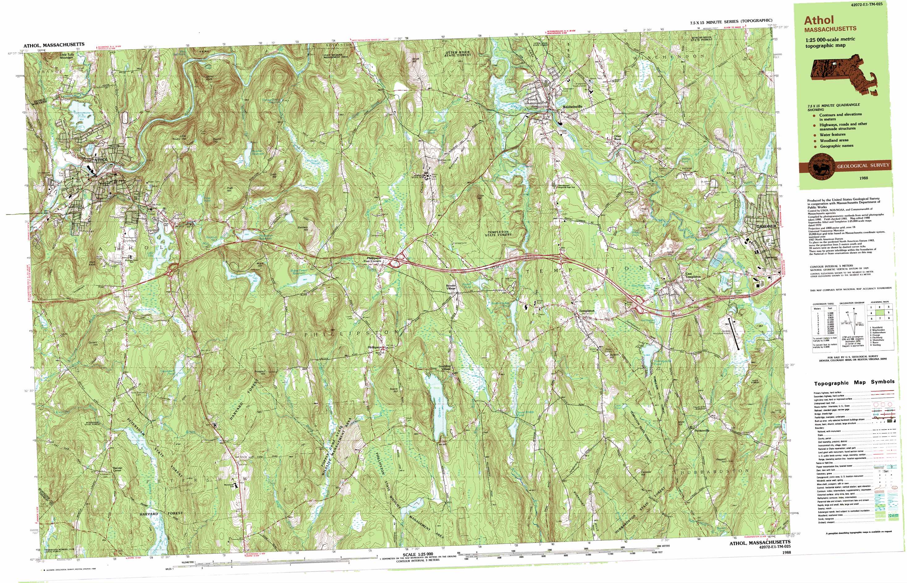
USGS Topo Quad 42072e1 - 1:25,000 scale
| Topo Map Name: | Templeton |
| USGS Topo Quad ID: | 42072e1 |
| Print Size: | ca. 39" wide x 24" high |
| Southeast Coordinates: | 42.5° N latitude / 72° W longitude |
| Map Center Coordinates: | 42.5625° N latitude / 72.125° W longitude |
| U.S. State: | MA |
| Filename: | k42072e1.jpg |
| Download Map JPG Image: | Templeton topo map 1:25,000 scale |
| Map Type: | Topographic |
| Topo Series: | 7.5´x15´ |
| Map Scale: | 1:25,000 |
| Source of Map Images: | United States Geological Survey (USGS) |
| Alternate Map Versions: |
Athol MA 1988, updated 1988 Download PDF Buy paper map |
1:24,000 Topo Quads surrounding Templeton
West Swanzey |
Monadnock Mountain |
Peterborough South |
Greenville |
|
Mount Grace |
Winchendon |
Ashby |
||
Orange |
Templeton |
Fitchburg |
||
Quabbin Reservoir |
Barre |
Sterling |
||
Winsor Dam |
North Brookfield |
Worcester North |
> Back to 42072e1 at 1:100,000 scale
> Back to 42072a1 at 1:250,000 scale
> Back to U.S. Topo Maps home
Templeton topo map: Gazetteer
Templeton: Airports
Gardner Municipal Airport elevation 286m 938′Templeton: Dams
Athol Manufacturing Dam elevation 228m 748′Baldwin Water Supply Pond Dam elevation 276m 905′
Bates Power Reservoir Dam elevation 346m 1135′
Beagle Pond Dam elevation 302m 990′
Bourn - Hadley Pond Dam elevation 265m 869′
Brazell Pond Dam elevation 283m 928′
Crescent Street Dam elevation 162m 531′
Lake Ellis Dam elevation 253m 830′
Newton Reservoir Dam elevation 284m 931′
Otter River Dam elevation 269m 882′
Parker Pond Dam elevation 289m 948′
Partridgeville Pond Dam elevation 335m 1099′
Perley Brook Reservoir Dam elevation 302m 990′
Phillipston Reservoir Dam elevation 318m 1043′
Queen Lake Dam elevation 344m 1128′
Reservoir Dam Number Two elevation 351m 1151′
Riceville Pond Dam elevation 230m 754′
Ridgley Pond Dam elevation 305m 1000′
Sportsmans Pond Dam elevation 160m 524′
Wetmore Pond Dam elevation 281m 921′
Templeton: Forests
Harvard Forest elevation 232m 761′Hubbardston State Forest elevation 316m 1036′
Otter River State Forest elevation 286m 938′
Petersham State Forest elevation 265m 869′
Templeton State Forest elevation 272m 892′
Winchendon State Forest elevation 324m 1062′
Templeton: Lakes
Bennett Pond elevation 285m 935′Cook Pond elevation 349m 1145′
Day Millpond elevation 256m 839′
Duck Pond elevation 211m 692′
East Templeton Pond elevation 319m 1046′
Greenwood Pond elevation 322m 1056′
Hansel Pond elevation 287m 941′
Kendall Pond elevation 281m 921′
Lake Ellis elevation 253m 830′
Paige Pond elevation 292m 958′
Silver Lake elevation 378m 1240′
Silver Lake elevation 160m 524′
Snake Pond elevation 282m 925′
Stone Bridge Pond elevation 263m 862′
Ward Pond elevation 181m 593′
Templeton: Parks
Baldwinville Village Historic District elevation 272m 892′Fish Park elevation 156m 511′
Gilman-Waite Field elevation 269m 882′
Greenwood Playground elevation 305m 1000′
Olivia Case Playground elevation 330m 1082′
Templeton Common Historic District elevation 348m 1141′
The Common elevation 347m 1138′
Wilder Field elevation 308m 1010′
Templeton: Populated Places
Athol elevation 170m 557′Baldwinville elevation 271m 889′
Brooks Village elevation 325m 1066′
Burrage Corner elevation 260m 853′
East Templeton elevation 316m 1036′
Goulding Village elevation 329m 1079′
Otter River elevation 272m 892′
Partidgeville elevation 336m 1102′
Partridgeville elevation 336m 1102′
Phillipston elevation 354m 1161′
Phillipston Four Corners elevation 320m 1049′
Pinedale elevation 171m 561′
Pitcherville elevation 322m 1056′
Templeton elevation 347m 1138′
Templeton Station elevation 293m 961′
The Street elevation 277m 908′
Templeton: Post Offices
Athol Post Office elevation 161m 528′Templeton: Ranges
Burnshirt Hills elevation 345m 1131′Templeton: Reservoirs
Bates Powers Reservoir elevation 348m 1141′Beagle Pond elevation 302m 990′
Bourn-Hadley Pond elevation 265m 869′
Brazell Pond elevation 283m 928′
Davenport Pond elevation 262m 859′
Depot Pond elevation 275m 902′
Hilchey Pond elevation 294m 964′
Millers River Reservoir elevation 162m 531′
Millers River Reservoir elevation 228m 748′
Newton Reservoir elevation 282m 925′
Otter River Reservoir elevation 269m 882′
Parker Pond elevation 289m 948′
Partridgeville Pond elevation 331m 1085′
Perley Brook Reservoir elevation 311m 1020′
Phillipston Reservoir elevation 319m 1046′
Queen Lake elevation 344m 1128′
Reservoir Number One elevation 306m 1003′
Reservoir Number Two elevation 351m 1151′
Riceville Pond elevation 231m 757′
Ridgley Pond elevation 307m 1007′
Sportsmans Pond elevation 160m 524′
Summer Street Reservoir elevation 259m 849′
Thousand Acre Reservoir elevation 285m 935′
Wetmore Pond elevation 281m 921′
Templeton: Ridges
Demadale Ridge elevation 376m 1233′Templeton: Streams
Bailey Brook elevation 274m 898′Bigelow Brook elevation 282m 925′
Buckman Brook elevation 218m 715′
Chickering Brook elevation 308m 1010′
Company Brook elevation 156m 511′
Crow Hill Brook elevation 255m 836′
Dunn Brook elevation 308m 1010′
East Branch Tully River elevation 160m 524′
Foster Brook elevation 280m 918′
Gulf Brook elevation 212m 695′
Hoyt Brook elevation 258m 846′
Hubbardston Brook elevation 280m 918′
Ice Company Branch elevation 155m 508′
Kendall Brook elevation 311m 1020′
Lamb City Brook elevation 308m 1010′
Mill Brook elevation 156m 511′
Nelson Brook elevation 229m 751′
Norcross Hill Brook elevation 251m 823′
Perley Brook elevation 279m 915′
Pond Brook elevation 280m 918′
Popple Camp Brook elevation 285m 935′
Rich Brook elevation 233m 764′
Shattuck Brook elevation 284m 931′
Stony Brook elevation 274m 898′
Templeton Brook elevation 280m 918′
Thousand Acre Brook elevation 232m 761′
Trout Brook elevation 251m 823′
Tully River elevation 155m 508′
West Branch Tully River elevation 160m 524′
West Gulf Brook elevation 217m 711′
Wilder Brook elevation 295m 967′
Wine Brook elevation 304m 997′
Templeton: Summits
Baldwin Hill elevation 411m 1348′Canesto Hill elevation 400m 1312′
Church Hill elevation 350m 1148′
Cobb Hill elevation 376m 1233′
Conant Hill elevation 285m 935′
Crow Hill elevation 348m 1141′
Dolbier Hill elevation 389m 1276′
Elliott Hill elevation 357m 1171′
Greenwood Hill elevation 349m 1145′
High Knob elevation 300m 984′
Little Round Top elevation 341m 1118′
Mine Hill elevation 362m 1187′
Norcross Hill elevation 342m 1122′
Pierce Hill elevation 349m 1145′
Pratt Hill elevation 394m 1292′
Prospect Hill elevation 416m 1364′
Ragged Hill elevation 386m 1266′
Round Top elevation 388m 1272′
Searle Hill elevation 383m 1256′
Sheep Rock elevation 293m 961′
Ward Hill elevation 405m 1328′
Templeton: Swamps
Thousand Acre Swamp elevation 292m 958′Tom Swamp elevation 230m 754′
Templeton digital topo map on disk
Buy this Templeton topo map showing relief, roads, GPS coordinates and other geographical features, as a high-resolution digital map file on DVD:
New York, Vermont, Connecticut & Western Massachusetts
Buy digital topo maps: New York, Vermont, Connecticut & Western Massachusetts