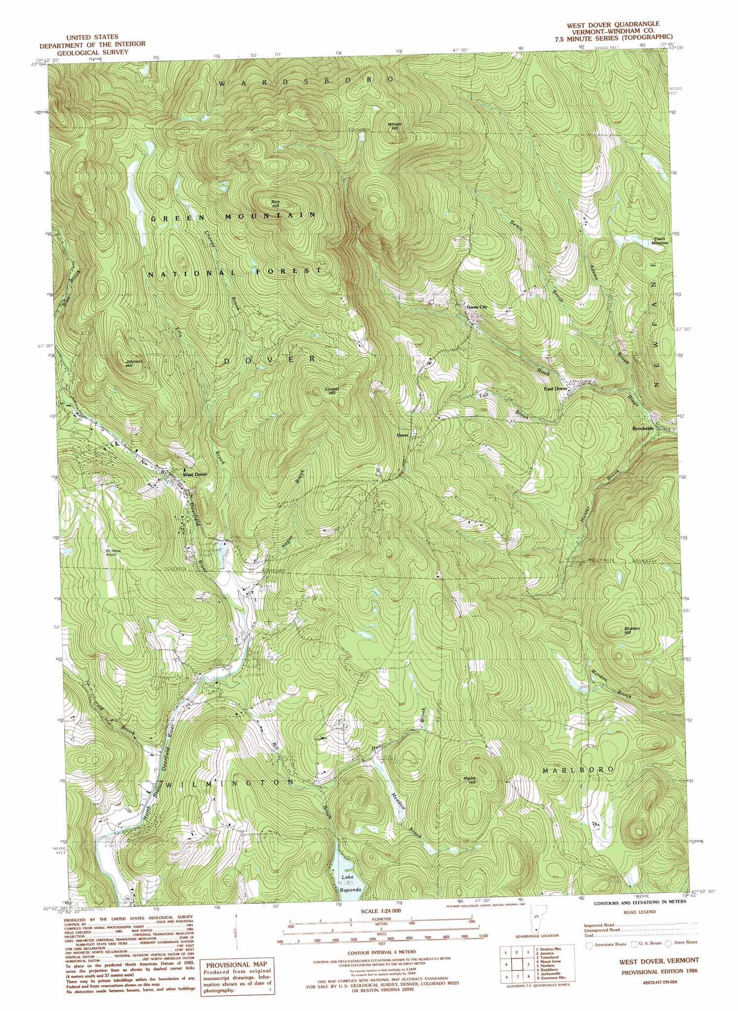
West Dover Topo Map Vermont
To zoom in, hover over the map of West Dover
USGS Topo Quad 42072h7 - 1:24,000 scale
| Topo Map Name: | West Dover |
| USGS Topo Quad ID: | 42072h7 |
| Print Size: | ca. 21 1/4" wide x 27" high |
| Southeast Coordinates: | 42.875° N latitude / 72.75° W longitude |
| Map Center Coordinates: | 42.9375° N latitude / 72.8125° W longitude |
| U.S. State: | VT |
| Filename: | o42072h7.jpg |
| Download Map JPG Image: | West Dover topo map 1:24,000 scale |
| Map Type: | Topographic |
| Topo Series: | 7.5´ |
| Map Scale: | 1:24,000 |
| Source of Map Images: | United States Geological Survey (USGS) |
| Alternate Map Versions: |
West Dover VT 1986, updated 1987 Download PDF Buy paper map West Dover VT 1997, updated 2000 Download PDF Buy paper map West Dover VT 2012 Download PDF Buy paper map West Dover VT 2015 Download PDF Buy paper map |
| FStopo: | US Forest Service topo West Dover is available: Download FStopo PDF Download FStopo TIF |
1:24,000 Topo Quads surrounding West Dover
Manchester |
Peru |
Londonderry |
Saxtons River |
|
Sunderland |
Stratton Mountain |
Jamaica |
Westminster West |
|
Woodford |
Mount Snow |
West Dover |
Putney |
|
Stamford |
Readsboro |
Jacksonville |
Brattleboro |
|
North Adams |
Heath |
Bernardston |
> Back to 42072e1 at 1:100,000 scale
> Back to 42072a1 at 1:250,000 scale
> Back to U.S. Topo Maps home
West Dover topo map: Gazetteer
West Dover: Airports
Mount Snow Airport elevation 592m 1942′West Dover: Flats
Elwin Meadow elevation 417m 1368′West Dover: Lakes
Lake Raponda elevation 558m 1830′West Dover: Parks
Dover Common elevation 573m 1879′West Dover Historic District elevation 517m 1696′
West Dover: Populated Places
Brookside elevation 286m 938′Dover elevation 584m 1916′
East Dover elevation 341m 1118′
Goose City elevation 392m 1286′
West Dover elevation 516m 1692′
West Dover: Post Offices
Dover Post Office elevation 569m 1866′West Dover: Streams
Adams Brook elevation 293m 961′Bemis Brook elevation 330m 1082′
Bill Brook elevation 475m 1558′
Blue Brook elevation 533m 1748′
Cheney Brook elevation 554m 1817′
Cold Brook elevation 469m 1538′
Ellis Brook elevation 480m 1574′
Hall Brook elevation 520m 1706′
Hunter Brook elevation 280m 918′
Meadow Brook elevation 537m 1761′
Negus Brook elevation 480m 1574′
Taft Brook elevation 327m 1072′
West Dover: Summits
Cooper Hill elevation 780m 2559′Higley Hill elevation 687m 2253′
Johnson Hill elevation 751m 2463′
Rice Hill elevation 894m 2933′
Stratton Hill elevation 587m 1925′
Whites Hill elevation 802m 2631′
West Dover digital topo map on disk
Buy this West Dover topo map showing relief, roads, GPS coordinates and other geographical features, as a high-resolution digital map file on DVD:
New York, Vermont, Connecticut & Western Massachusetts
Buy digital topo maps: New York, Vermont, Connecticut & Western Massachusetts