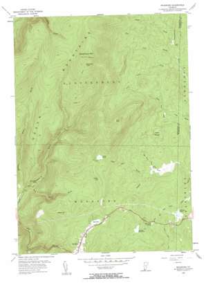
Woodford Topo Map Vermont
To zoom in, hover over the map of Woodford
USGS Topo Quad 42073h1 - 1:24,000 scale
| Topo Map Name: | Woodford |
| USGS Topo Quad ID: | 42073h1 |
| Print Size: | ca. 21 1/4" wide x 27" high |
| Southeast Coordinates: | 42.875° N latitude / 73° W longitude |
| Map Center Coordinates: | 42.9375° N latitude / 73.0625° W longitude |
| U.S. State: | VT |
| Filename: | o42073h1.jpg |
| Download Map JPG Image: | Woodford topo map 1:24,000 scale |
| Map Type: | Topographic |
| Topo Series: | 7.5´ |
| Map Scale: | 1:24,000 |
| Source of Map Images: | United States Geological Survey (USGS) |
| Alternate Map Versions: |
Woodford VT 1954, updated 1957 Download PDF Buy paper map Woodford VT 1954, updated 1961 Download PDF Buy paper map Woodford VT 1954, updated 1961 Download PDF Buy paper map Woodford VT 1997, updated 2000 Download PDF Buy paper map Woodford VT 2012 Download PDF Buy paper map Woodford VT 2015 Download PDF Buy paper map |
| FStopo: | US Forest Service topo Woodford is available: Download FStopo PDF Download FStopo TIF |
1:24,000 Topo Quads surrounding Woodford
> Back to 42073e1 at 1:100,000 scale
> Back to 42072a1 at 1:250,000 scale
> Back to U.S. Topo Maps home
Woodford topo map: Gazetteer
Woodford: Dams
Adams Reservoir Dam elevation 711m 2332′Bugbee Pond Dam elevation 661m 2168′
Ricker Dam elevation 626m 2053′
Woodford: Lakes
Big Pond elevation 690m 2263′Billings Pond elevation 646m 2119′
Little Pond elevation 793m 2601′
Lost Pond elevation 900m 2952′
Mill Pond elevation 623m 2043′
Red Mill Pond elevation 681m 2234′
Woodford: Parks
Woodford State Park elevation 695m 2280′Woodford State Park elevation 714m 2342′
Woodford: Populated Places
Woodford elevation 672m 2204′Woodford: Reservoirs
Adams Reservoir elevation 711m 2332′Bugbee Mill Pond elevation 664m 2178′
Bugbee Pond elevation 661m 2168′
Woodford: Streams
Bickford Hollow Brook elevation 396m 1299′Blind Brook elevation 626m 2053′
Bolles Brook elevation 396m 1299′
Deer Cabin Brook elevation 605m 1984′
Deer Lick Brook elevation 618m 2027′
Hell Hollow Brook elevation 409m 1341′
Little Pond Brook elevation 621m 2037′
Mill Pond Brook elevation 620m 2034′
Red Mill Pond Brook elevation 643m 2109′
Redfield Brook elevation 590m 1935′
South Pond Brook elevation 621m 2037′
Stamford Stream elevation 440m 1443′
Woodford: Summits
Glastenbury Mountain elevation 1140m 3740′Hagar Hill elevation 842m 2762′
Maple Hill elevation 818m 2683′
Woodford: Swamps
Castle Meadow elevation 638m 2093′Woodford: Trails
Atwood Trail elevation 695m 2280′Molly Stark Trail elevation 718m 2355′
Woodford: Valleys
Dunville Hollow elevation 440m 1443′Woodford digital topo map on disk
Buy this Woodford topo map showing relief, roads, GPS coordinates and other geographical features, as a high-resolution digital map file on DVD:
New York, Vermont, Connecticut & Western Massachusetts
Buy digital topo maps: New York, Vermont, Connecticut & Western Massachusetts


