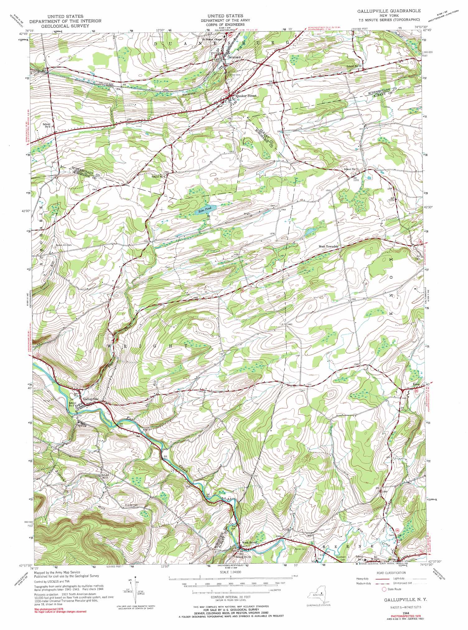
Gallupville Topo Map New York
To zoom in, hover over the map of Gallupville
USGS Topo Quad 42074f2 - 1:24,000 scale
| Topo Map Name: | Gallupville |
| USGS Topo Quad ID: | 42074f2 |
| Print Size: | ca. 21 1/4" wide x 27" high |
| Southeast Coordinates: | 42.625° N latitude / 74.125° W longitude |
| Map Center Coordinates: | 42.6875° N latitude / 74.1875° W longitude |
| U.S. State: | NY |
| Filename: | o42074f2.jpg |
| Download Map JPG Image: | Gallupville topo map 1:24,000 scale |
| Map Type: | Topographic |
| Topo Series: | 7.5´ |
| Map Scale: | 1:24,000 |
| Source of Map Images: | United States Geological Survey (USGS) |
| Alternate Map Versions: |
Gallupville NY 1944, updated 1959 Download PDF Buy paper map Gallupville NY 1944, updated 1973 Download PDF Buy paper map Gallupville NY 1944, updated 1990 Download PDF Buy paper map Gallupville NY 2010 Download PDF Buy paper map Gallupville NY 2013 Download PDF Buy paper map Gallupville NY 2016 Download PDF Buy paper map |
1:24,000 Topo Quads surrounding Gallupville
Randall |
Tribes Hill |
Amsterdam |
Pattersonville |
Burnt Hills |
Carlisle |
Esperance |
Duanesburg |
Rotterdam Junction |
Schenectady |
Cobleskill |
Schoharie |
Gallupville |
Altamont |
Voorheesville |
Breakabeen |
Middleburgh |
Rensselaerville |
Westerlo |
Clarksville |
Gilboa |
Livingstonville |
Durham |
Greenville |
Alcove |
> Back to 42074e1 at 1:100,000 scale
> Back to 42074a1 at 1:250,000 scale
> Back to U.S. Topo Maps home
Gallupville topo map: Gazetteer
Gallupville: Airports
Boss Airport elevation 404m 1325′Flying K Ranch Airport elevation 359m 1177′
Knox Airport elevation 336m 1102′
Wandervogel Gliderport elevation 379m 1243′
West Township Airport elevation 384m 1259′
Gallupville: Populated Places
Berne elevation 296m 971′Delanson elevation 249m 816′
Gallupville elevation 220m 721′
Quaker Street elevation 310m 1017′
West Berne elevation 286m 938′
West Township elevation 383m 1256′
Gallupville: Reservoirs
Echo Pond elevation 378m 1240′Gallupville: Streams
Beaverdam Creek elevation 286m 938′King Creek elevation 208m 682′
Ox Kill elevation 226m 741′
Gallupville: Summits
Zimmer Hill elevation 372m 1220′Gallupville digital topo map on disk
Buy this Gallupville topo map showing relief, roads, GPS coordinates and other geographical features, as a high-resolution digital map file on DVD:
New York, Vermont, Connecticut & Western Massachusetts
Buy digital topo maps: New York, Vermont, Connecticut & Western Massachusetts