Cobleskill Topo Map New York
To zoom in, hover over the map of Cobleskill
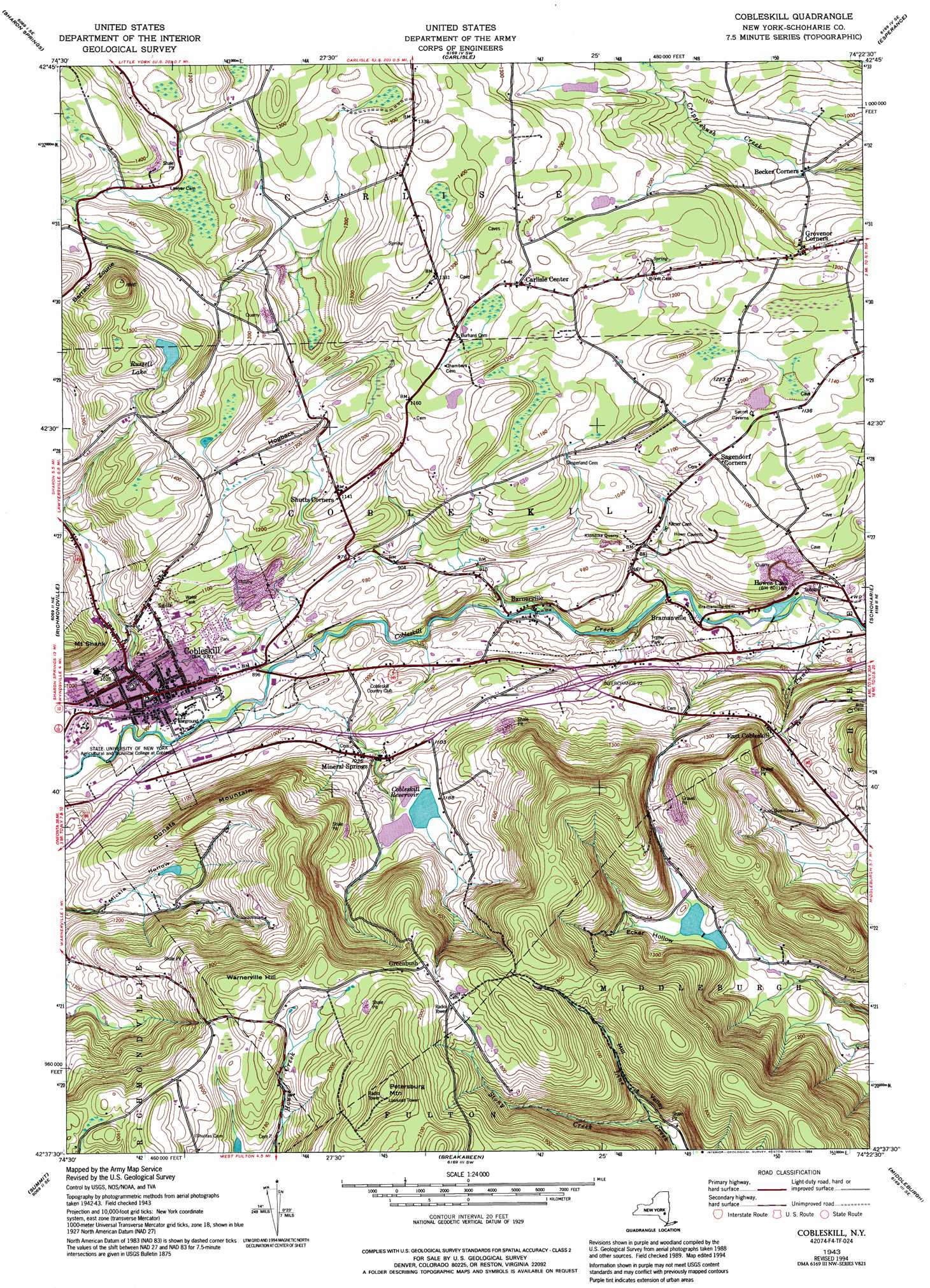
USGS Topo Quad 42074f4 - 1:24,000 scale
| Topo Map Name: | Cobleskill |
| USGS Topo Quad ID: | 42074f4 |
| Print Size: | ca. 21 1/4" wide x 27" high |
| Southeast Coordinates: | 42.625° N latitude / 74.375° W longitude |
| Map Center Coordinates: | 42.6875° N latitude / 74.4375° W longitude |
| U.S. State: | NY |
| Filename: | o42074f4.jpg |
| Download Map JPG Image: | Cobleskill topo map 1:24,000 scale |
| Map Type: | Topographic |
| Topo Series: | 7.5´ |
| Map Scale: | 1:24,000 |
| Source of Map Images: | United States Geological Survey (USGS) |
| Alternate Map Versions: |
Cobleskill NY 1943, updated 1954 Download PDF Buy paper map Cobleskill NY 1943, updated 1969 Download PDF Buy paper map Cobleskill NY 1943, updated 1980 Download PDF Buy paper map Cobleskill NY 1943, updated 1994 Download PDF Buy paper map Cobleskill NY 1996, updated 2000 Download PDF Buy paper map Cobleskill NY 2010 Download PDF Buy paper map Cobleskill NY 2013 Download PDF Buy paper map Cobleskill NY 2016 Download PDF Buy paper map |
1:24,000 Topo Quads surrounding Cobleskill
Fort Plain |
Canajoharie |
Randall |
Tribes Hill |
Amsterdam |
Sprout Brook |
Sharon Springs |
Carlisle |
Esperance |
Duanesburg |
South Valley |
Richmondville |
Cobleskill |
Schoharie |
Gallupville |
Charlotteville |
Summit |
Breakabeen |
Middleburgh |
Rensselaerville |
Harpersfield |
Stamford |
Gilboa |
Livingstonville |
Durham |
> Back to 42074e1 at 1:100,000 scale
> Back to 42074a1 at 1:250,000 scale
> Back to U.S. Topo Maps home
Cobleskill topo map: Gazetteer
Cobleskill: Lakes
Russell Lake elevation 435m 1427′Cobleskill: Mines
Cobleskill Quarry elevation 337m 1105′Klondike Quarry elevation 281m 921′
Cobleskill: Parks
Crittenden Athletic Fields elevation 278m 912′Cobleskill: Populated Places
Barnerville elevation 252m 826′Bramanville elevation 231m 757′
Carlisle Center elevation 390m 1279′
Cobleskill elevation 281m 921′
East Cobleskill elevation 344m 1128′
Greenbush elevation 568m 1863′
Grovenor Corners elevation 344m 1128′
Howes Cave elevation 238m 780′
Mineral Springs elevation 317m 1040′
Cobleskill: Reservoirs
Cobleskill Reservoir elevation 354m 1161′Cobleskill: Streams
Punch Kill elevation 214m 702′Stony Creek elevation 393m 1289′
Cobleskill: Summits
Barrack Zourie elevation 552m 1811′Donats Mountain elevation 436m 1430′
Hogback elevation 389m 1276′
Mount Shank elevation 442m 1450′
Petersburg Mountain elevation 708m 2322′
Warnerville Hill elevation 606m 1988′
Cobleskill: Valleys
Ecker Hollow elevation 356m 1167′Cobleskill digital topo map on disk
Buy this Cobleskill topo map showing relief, roads, GPS coordinates and other geographical features, as a high-resolution digital map file on DVD:
New York, Vermont, Connecticut & Western Massachusetts
Buy digital topo maps: New York, Vermont, Connecticut & Western Massachusetts